Geology of the South China Sea
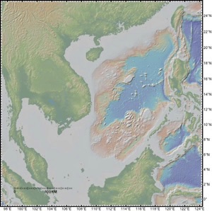
The South China Sea is one of the largest sedimentary basins in eastern Asia and of great scientific and economic interest. It is a great place to examine the nature of strain accommodation during rifting of ocean basins because the conjugate margins are easy to match and the timing of extension is relatively well known from magnetic studies of the deep basin. Despite a wealth of industrial data debate continues about why the basin exists in the first place, whether because of the SE-ward extrusion of SE Asia due to indentation of India into Asia or whether it reflect subduction plate stresses to the south.
Using seismic data from the souther margin I have worked to show that the Dangerous Grounds were independent of Sundaland until ~16 Ma so that its motion cannot have been constrained by motion of this block. This in turn makes extrusion impossible as a mechanism to rift the South China Sea. SE motion by both the Dangerous Grounds and Sundaland suggests subduction forces were the primary trigger for plate motions. My reconstruction places a ~280 km upper limit on the motion on the Red River Fault, and a ~1400 km width to the paleo-South China Sea.
I am further interested in the role that lower crust flow has played in shaping the continental margins and the role that surface processes on land have played in the development of the marginal basin. The total amount of subsidence on the passive rifted margins greatly exceeds that predicted from the degree of upper crustal faulting and extension. Subsidence anomalies reflect preferential thinning of the lower crust by ductile flow prior to the onset of seafloor spreading within ~80 km of the new continent-ocean transition (COT). In addition, subsidence analysis of the Yinggehai and Baiyun Sag basins also in the South China Sea shows that anomalous tectonic subsidence events can occur far from the COT. However, in these cases flow and subsidence follows enhanced sediment flux to the basin, triggered by climatically driven erosion onshore.
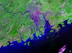
EVOLUTION OF THE PEARL RIVER BASIN
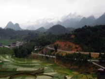
The East Asian Monsoon dominates the environmental conditions in the Asian continental interior, the oceanography of the surrounding seas, and is a major control on erosion and the supply of sediment to the continental margins around Asia over a variety of timescales. Despite this significance, it is unclear what the effect of monsoon intensification is on continental weathering and erosion rates. I am now running a project to measure a variety of continental weathering and erosion indicators spanning the last 14 ka and compare them to the robust monsoon records derived from speleothem deposits in order to determine links between monsoon strength and continental weathering at millennial timescales in the South China Sea region. At ODP Site 1144 on the continental margin SW of Taiwan we have shown that none of our chemical proxies shows an erosional response lasting until ~6 ka, when speleothem oxygen isotope records indicate monsoon weakening. Erosion was enhanced during monsoon strengthening and caused reworking of weathered Pleistocene sediment largely from the now flooded Taiwan Strait, which was transgressed by ~8 ka, cutting off supply to the deep-water margin. Although weathered sediments were deposited from 11 to 8 ka these are reworked and represent stronger weathering during the extended last glacial maximum (LGM) when the summer monsoon was weaker but the shelves were exposed.
Work now continues to determine how the Pearl River basin itself has reacted to climate change since the LGM. Initial results show a close coupling between climate change and weathering of sediment in the Pearl River delta. However, the delta results are in stark contrast with compositions of the modern river sediment suggesting that agriculture and human settlement has greatly disrupted the landscape and the nature of sediment flux to the ocean during the last 2000 years.