Active Projects
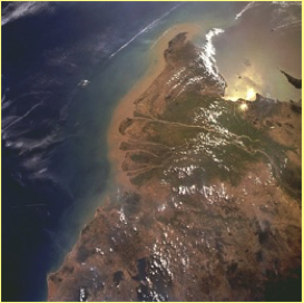
Climate-Tectonic Interactions in the Arabian Sea
Development of high topography in Asia and changes in monsoon strength represent the world type example of how the solid Earth and atmosphere might influence each other over timescales of greater than 1 Ma. We investigate how erosion in the Western Himalaya may be linked to changes in monsoon intensity since the late Miocene. Using samples taken by IODP Expedition 355 in the Arabian Sea as well as from the onshore Siwalik Group we are reconstructing the changing patterns and rates of erosion in the mountains since around 11 Ma. We will establish if there are links between the structural evolution of the mountains and changing surface processes. We further aim to link erosion and weathering with environmental conditions reconstructed by palynology and biomarker work.
Project partners: Peng Zhou (North Kentucky University), Elise Exnicos, Peter Clift, Jerzy Blusztajn (Woods Hole Oceanographic Institution), Danny Stockli (University of Texas).
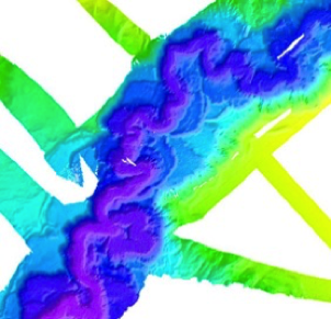
Sediment Flux through the Indus Canyon
Transport of sediment through canyons on continental margins is one of the primary processes that builds the submarine fans observed in many deep-sea basins. In this project we exploit a new and uniquely well-arranged series of cores from along the axis and on the sides of the Indus Canyon to test what controls the flux of sediment through this conduit to the upper fan since the Last Glacial Maximum. We evaluate the roles played by cyclones, sediment supply and sea level variations in feeding sediment to the deep sea and assess the continuity of sandy channel fills.
Project participants: Yuting Li (University of North Texas), Peter Clift, Liviu Giosan (Woods Hole Oceanographic Institution), Paul O'Sullivan (GeoSep Services)
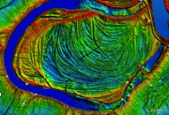
Sedimentology of meander loops
False River, a meander loop of the Mississippi River, contains a classic example of a point bar system which has yet to be fully understood. Although small-scale systems have been studied in the past, the constructional history of large meandering rivers, such as the Mississippi, is poorly known. By studying three parts of the point bar, which have been selected based on discontinuities mapped from LiDAR topography, we hope to define the internal architecture of the system in order to understand what controlled it's development, as well as gain a better understanding of how sediment is transported through large meandering river systems.
Project participants: Nikki Neubeck, Juan Lorenzo, Peter Clift and Catherine Russell (Leicester Univesity). Former participants: Alexandra Lechnowskyj, Liz Olson
Drainage Reorganization
The development of high topography in Asia has been accompanied by the re-organization of the major rivers of the region. as the South and East China Seas opened and the Tibetan plateau increased in elevation the regional topography tilted to the east resulting in a break-up of the original river system. Models that proposed that the Red River was the ancestral mother river of Eastern Asia are being tested using a variety of provenance and sediment budget techniques. We propose the importance of reorganization around the start of the Miocene, around 24 million years ago. Zircon U-Pb dating now indicates that the Yangtze River was close to its present form before 22 million years ago.
Project participants: Peter Clift, Zheng Hongbo (Yunan University), Anna Wysocka (University of Warsaw), Hoang Van Long (Vietnam Petroleum Institute), Mengying Connie He (Nanjing Normal University), Andrew Carter (Birkbeck London)
Himalayan Foreland
The Siwalik sediments of the HImalayan foreland basin were deposited by rivers draining the early ranges of the HImalaya since the Early Miocene. Together with sediments drilled from the Indus submarine fan we are examining the erosion history of the NW Himalaya and Karakoram in order to understand how quickly and when the various tectonic units were brought to the surface and to assess whether this process was related to strengthening or weakening of monsoon summer rainfall. Our records from NW India span to 21 Ma, too young to test the impact of initial monsoon strengthening but sufficient to examine the impact of later changes, especially at 15 and 8 Ma. We employ zircon U-Pb dating to test when the Inner Lesser Himalaya were first exhumed and their impact on the bulk composition of the Indus River.mocha
Project participants: Elise Exnicios, Peter Clift, Yani Najman (Lancaster University)
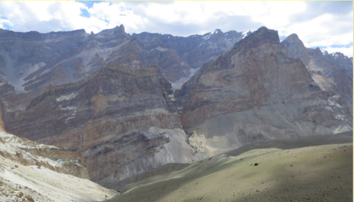
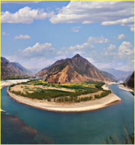
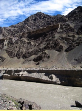
The Indus River is the dominant drainage in the Western Himalaya and supplies the second-largest sediment body on the planet. Recent work from the floodplains of the Indus in Pakistan suggests that storage and recycling of sediment is one of the most important controls on delivery of sediment to the ocean. We now investigate this further through mapping and dating of terraces in the higher part of catchment beyond the rain shadow of the Greater Himalaya, in Zanskar, India. Using OSL dating and zircon geochronology for provenance work we constrain the source of sediment into the Zanskar River and test whether changes in monsoon strength since the last glacial maximum are responsible for the storage and release of sediment into the main Indus stream.
Project participants: Tara Jonell (University of Queensland), Peter Clift, Lewis Owen (North Carolina State), Liviu Giosan (Woods Hole Oceanographic Institution)
Weathering history of South China Sea
Being one of the largest basins in the world, South China Sea is also an ideal location to explore the impact of the monsoon on the eastern Asian continent. Several rivers transport the sediments and grains into the South China Sea, providing a continuous record of chemical weathering from the continent. In this project, our key question is seeing how the monsoon affects chemical weathering rates in South China Sea. Our purpose is to find whether higher chemical weathering rate will be detected under a humid climate with more monsoon intensity or under a cold dry glacial period. To test our hypothesis, we employed several geochemical measurements, clay mineralogy , and isotope analysis. We compare the chemical weathering rates, monsoon intensity and glacial-interglacial cycles over the past 23 Ma in the South China Sea.
Project participants: Chang Liu (IODP), Peter Clift, Philipp Boening (Oldenberg), Shiming Wan (QIngdao)
Sedimentation and Sea Level Rise in the Pearl River Delta
Recent and future sealevel rise influences coastal communities across Southeast Asia and particularly in the Greater Bay Area of the Pearl River, one of the economic hubs of southern China. In this project we aim to understand the role which delta sedimentation can play in protecting the coast against predicted future sealevel rises and in particular the areas of low land on the north and western side of the estuary. The start of our work will involve surveying deep bay in Hong Kong to look at cinnamon dispersal and the role that mangroves and oyster Rhys may play in sequestering Sunderland close to the shore line rather than being washed out into the open waters of the South China Sea.
Project participants: Peter Clift, Nicole Khan, Sean Crowe and Jed Kaplan (University of Hong Kong), Jinpeng Zhang (Geological Survey of Guangzhou)
Sediment provenance and tectonics of the Irish Caledonides
The closure of the Iapetus Ocean in the Paleozoic in NW Europe is recorded in the formation of a series of mountain belts stretching from Norway through the British Isles and Ireland into NE North America in this project. We examine the origin of sediments in the Ordovician and Silurian of western Ireland and see how the source of the sediment evolves during and following the Grampian/Taconic orogeny, as well as during the phase of active margin evolution preceding the collision of Avalonia and other Gondwana terrains against the margin of Laurentia during the Silurian and in particular we employ U-Pb detrital zircon dating to define the origin of the grains and in particular the degree of reworking from recently accreted volcanic arcs compared to the ancient continental interior of North America.
Project participants: Peter Clift, Amy Luther, Maddie Avery, and Paul O'Sullivan (GeoSep Services)
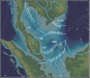
The Sunda Shelf
The Sunda Shelf is one of the largest continental shelves on Earth and covers a wide area across tropical Southeast Asia between Indochina and Borneo. It has been suggested that when the shelf is exposed during periods of low sealevel during glacial times that the enhanced chemical weathering and growth of tropical forests may interfere with atmospheric CO2 levels at a global level. We are undertaking a survey of the shelf using industrial seismic data particularly around the coast of Vietnam in order to quantify the amount of sediment and prepare for scientific drilling of the last 5 million years of sedimentation. We also aim to reconstruct the evolution of the drainage patterns across the shelf and relate those to the modern rivers of Southeast Asia.
Project participants: Peter Clift, Long Van Hoang (PetroVietnam), Tara Jonell (University of Queensland)