THE ORINOCO DELTA
Delta ID #29
Contributed by Huh et al, 2004.
Orinoco River Delta, Venezuela, South America
LOCATION LAT. 8°40’N, LONG. 61°15’W
LANDMASS DRAINED SOUTH AMERICA
BASIN OF DEPOSITION CARIBBEAN SEA
CLIMATE TROPICAL RAINFOREST (Af)
AIR TEMP RANGE 25°C – 29°C,
TIDAL AMPLITUDE 2.2 M
TYPE SEMIDIURNAL
DISCHARGE WATER 170 000 M
3/S SEDIMENT 210X106 TONS/YR,ID 7233054000225650, PATH 233 ROW 54
IMAGE ACQUIRED SEPTEMBER 13, 2002
Delta type:
Geo-referenced files
Description
Contributed by Professor James Coleman, LSU. From: Coleman and Huh, 2004.

The Orinoco River is one of the larger river systems in South America and has its source high up in the Guiana Highlands. The river meanders its way through dense rainforests. Major tributaries include the Caura and Caroni rivers. The major part of the drainage basin originates in the Pre-Cambrian Guyana Shield. The basin covers an area of 958,500 sq km and the main channel from its origin to the river mouth is 1,531 km long. Average relief in the basin is 243 m and the average elevation is 442 m. Maximum elevation is 2,843 m and minimum elevation is 30 m. Drainage density is quite high, the average being 0.23 km stream length per 500 sq km (Figure 72). Note on this figure that the main tributaries are obviously oriented by structural features that trend roughly east-west in the western basin. The average annual rainfall is 1,998 mm per year with a maximum of 3,872 mm and a minimum of 648 mm. The rainy months are April through November and even during the dry months, rainfall averages 60 mm per month.
The alluvial valley is well defined and the river displays both braided and meandering sections within its valley. The lower part of the river tends to display a greater tendency towards meandering. The main valley of the river is very narrow and is approximately 830 km in length. The river channel is extremely complex and numerous small tributaries enter the main river (Figure 73). The small tributaries display extreme sinuosity. The average annual river discharge is 28,857 cu m/sec with a maximum of 58,822 cu m/sec (September) and a minimum of 5,641 cu m/sec (March).
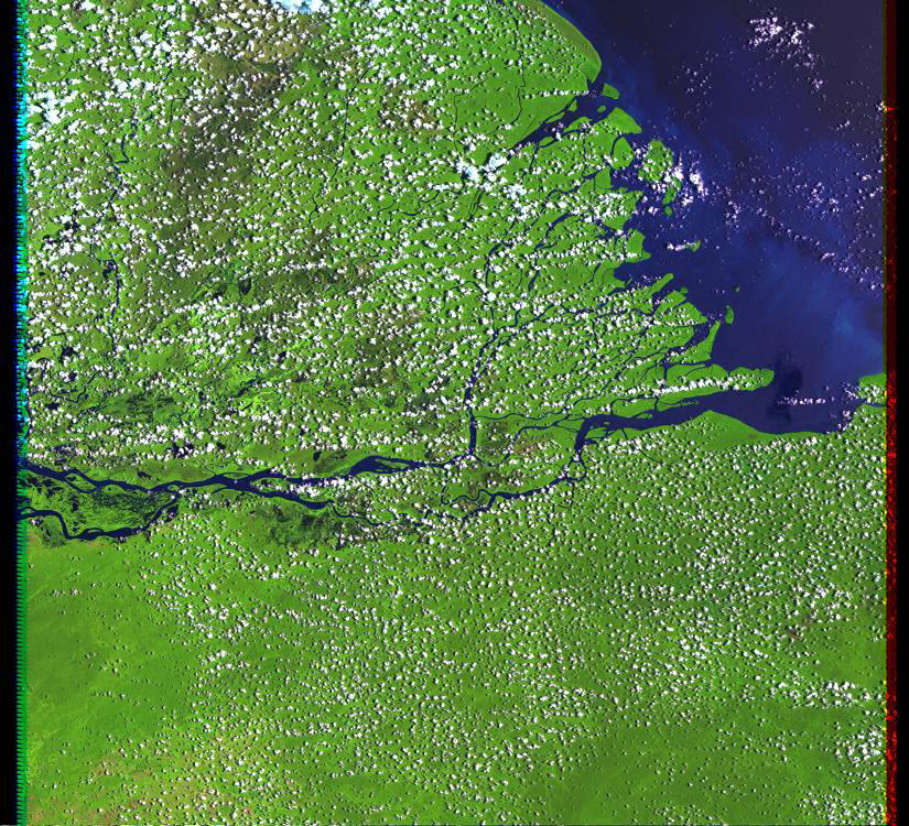
The Orinoco delta is a vast mosaic of interdistributary swamps and marshes encased by distributary and tidal channels (Bureau Economic Geology, Univ. Texas; http://www.beg.utexas.edu/geoenvirn/orinoco/summary/main/basic.htm . Much of the interdistributary regions are flooded annually. The delta is a complex maize of distributary channels [29-i06] and has an area of some 20,642 sq km. Much of the delta plain, especially to the west consists partially inactive distributary channels and broad peat dominant interdistributary areas (29-i03). The most active portion of the delta lies along the southern part of the delta plain, where the distributaries display complex anastomosing patterns. Most of the channels are strongly influenced by tidal action, particularly during the dry season. Tidal range in the delta proper is 1.77 m. The subaerial delta is some 8.6 times larger than the subaqueous delta, partially due to strong longshore currents that move sediment from the active river mouths to the east. Wave action is moderate along the coast; the root mean square wave height is 1.19 m. Strong coastal currents cause deflection of some of the distributary channels in the western delta to be strongly deflected to the west. Mangrove covered mudflats [29-i01; 29-i05] dominate much of the shoreline along with broad barren mudflats exposed at low tide. Levees support and active tree-bush vegetation [29-i02; 29-i04]. Small stranded beaches or cheniers are found within the delta plain, especially in the delta plain to the northwest.