MAJOR WORLD DELTAS
A PERSPECTIVE FROM SPACE
by
James M. Coleman and Oscar K. Huh
Coastal Studies Institute
Louisiana State University
Baton Rouge, LA
TABLE OF CONTENTS
INTRODUCTION……………………………………………………………4
Major River Systems and their Subsystem Components…….……..4
Drainage Basin………………………………………………..…..7
Alluvial Valley……………………………………………………15
&#&#Receiving Basin…………………………………………………….............15
Delta Plain……………………………………………….……….22
Deltaic Process-Form Variability: A Brief Summary…………………............….29
The Drainage Basin and The Discharge Regime…………………....29
Near shore Marine Energy Climate And Discharge Effectiveness…..29
River-Mouth Process-Form Variability………………………........36
DELTA DESCRIPTIONS……………………………………………….........37
Amu Darya River System……………………………………………….......…45
Baram River System……………………………………………………...…...49
Burdekin River System…………………………………………………….....53
Chao Phraya River System……………………………………….………..…57
Colville River System…………………………………………………...……62
Danube River System…………………………………………………..….…66
Dneiper River System…………………………………………………...……74
Ebro River System……………………………………………………....……77
Fly River System………………………………………………………....…..79
Ganges-Brahmaputra River System……………………………………...……83
Girjalva River System…………………………………………………..….…91
Krishna-Godavari River System………………………………………..…… 94
Huang He River System………………………………………………....……99
Indus River System…………………………………………………………105
Irrawaddy River System……………………………………………………113
Klang River System……………………………………………………...…117
Lena River System……………………………………………………….…121
MacKenzie River System………………………………………………..…126
Magdelena River System……………………………………………..….…130
Mahakam River System………………………………………………….…134
Mahanadi River System………………………………………………….…137
Mangoky River System…………………………………………………..…140
Mekong River System…………………………...………………………… 146
Mississippi River System………………………………………………...…151
Niger River System…………………………………………………………160
Nile River System…………………………………………………………..165
Ord River System…………………………………………………………...171
Orinoco River System………………………………………………………176
Parana River System………………………………………………………..180
Pechora River System………………………………………………………183
Po River System……………………………………………………………186
Pungoe River System…………………………………………………….…189
Red River System………………………………………………………...…192
Salenga River System…………………………………………………….…195
Sao Francisco River System…………………………………..…………….198
Senegal River System…………………………………………………….…202
Shatt el Arab River System……………………………………………….…207
Volga River System…………………………………………………………213
Yangtze-Kiang River System…………………………………………….…221
Yukon River System…………………………………………….…………..225
Zambezi River System………………………………………………………230
CONCLUSIONS…………………………………………………………..235
REFERENCES CITED…………………………………………………..…238
INTRODUCTION
Deltas vary because of variations in associated process environment. Understanding delta variability involves (1) understanding the causal links between process environment and morphologic response (deterministic studies) and (2) knowledge of the actual process environments and responses and their global associations. In order to understand the reasons for the existence of deltaic forms, the details of deterministic associations between process and form and the conditions which exist in different parts of the world must be examined simultaneously. The study of deterministic associations can lead to establishment of universal cause-effect relationships and development of theoretical models. Investigation of global variability of process environments and delta forms permits evaluation of variations in intensity of forcing agents and morphologic responses and determination of the realistic spectrum of probable process-form models.
The purpose of this paper is to present the results of a comparison of delta forms and their associated process environment. The various morphometric data presented in the report was gathered from a variety of sources and was heavily dependent on delta data acquired in the early to mid 70’s. These data were acquired under an Office of Naval Research contract with the Coastal Studies Institute, Louisiana State University. The principle investigators were J. M. Coleman and L. D. Wright. The data was published in two documents, both technical reports of the Coastal Studies Institute (Coleman and Wright, 1971 and Wright, Coleman, and Erickson, 1974).
MAJOR RIVER SYSTEMS AND THEIR SUBSYSTEM COMPONENTS
This report is concerned primarily with river deltas and their variability. However, a delta is an integral part of a larger total river system and, to be adequately understood, must be considered in that context. Each component subsystem of a river system contributes in varying degrees to the characteristics of the delta. Because of the numerous interactions which take place between subsystems, the river system as a whole is more than the sum of its parts.
Figure 1 diagrammatically illustrates the spatial relationships between the basic river subsystem. A river system consists of at least four subsystems: (1) the drainage basin; (2) the alluvial valley; (3) the receiving basin; and (4) the delta plain. Within each of these subsystems, climatic, geologic, geomorphic, hydrologic, and biologic events mutually interact. Some of these interactions are illustrated in Figure 2. The drainage basin supplies water and sediment to the remainder of the river system and is characterized by net erosion; the alluvial valley is a graded conduit which, over the long term, experiences neither significant erosion nor deposition and through which water and sediment are transported en route from the drainage basin to the sea. The receiving basin serves as a sink for the water and sediment discharged by the river and supplies energy which opposes the seaward-directed riverine energy. The delta itself is, for the purpose of this study, regarded as the response to these various subsystem contributions. The delta is characterized by sediment dispersal and accumulation and results from the interactions between riverine and marine forces.
Drainage Basin. The drainage basin, or catchment, is the source of the water and sediment ultimately supplied to the delta. The amount and temporal distribution of river discharge are of paramount importance to deltaic sedimentation and are functions of basin climate, area, and shape. The sediment yield of a basin is affected by these same factors, as well as by basin geology, relief, and hypsometry.
A total of seven different variables were measured and recorded for drainage basins and are presented for each river system described. The seven parameters are: 1) drainage basin area, 2) stream length, 3) average basin elevation, 4) average basin relief, 5) tributary drainage density, 6) number of days with below freezing temperatures, and 7) average annual rainfall. The drainage basin area was obtained by digitizing the perimeter of the basin on geo-referenced topographic maps at a scale of 1:1,000,000 and imported into a software program that was used to calculate area. Figure 3 illustrates a graph of the drainage basin areas used in this report.
Stream length was digitized on the 1:1,000,000 scale maps and was traced from the headwaters to the river mouth outlet. Figure 4 illustrates a graph of the river lengths for the river systems analyzed. The average basin elevation was based on a random selection of elevations within the drainage basin. The number of points selected varied and no set number of points can be used to obtain an average elevation. In basins having low relief, few points are needed to determine the average, but in basins having extreme relief, a greater number of points are required. The major procedure was as follows: a) ten random points are generated and mean elevation and standard deviation are calculated, b) ten more points are randomly selected and the mean of the total (20 points) and standard deviation are calculated, and c) this process is continued until the standard deviation ceases to change significantly as additional points are measured. The number of points needed ranged from 60 to 900. Figure 5 illustrates the average elevation of the drainage basins in the river systems described. The average drainage basin relief was calculated in a similar manner to that described for calculating the average basin elevation. The relief in the vicinity of the random point is used for the calculation. Figure 6 illustrates the average basin relief for the river systems described. The drainage density is the length of the channels per unit area: Dd = ∑L/A; where ∑L is the summed length of channels per given area A in square kilometers. Drainage densities were measured at the same random points used in the relief analysis. At each point, a given area, usually 500 sq km, is blocked off and the lengths of all streams within this area are digitized. From the densities at each individual point, the mean and standard deviation are calculated. Figure 7 illustrates the drainage density for the river systems described. The number of days that the temperature is below freezing was gathered from a variety of climatic sources. Figure 8 illustrates the number of days the temperature in the drainage basin was below freezing for the river systems described. The average annual rainfall was derived from various climatic maps. Figure 9 illustrates the average annual rainfall, in mm, for each drainage basin in the river systems described.
Alluvial Valley. Unlike the drainage basin, which functions as a supplier of sediment and water and experiences net erosion, the alluvial valley is approximately a balanced system in which the river flows through its own deposits. Typically, there is neither net erosion nor deposition. It is through this conduit that riverine energy, fluid, and sediment mass, derived from the drainage basin, are transmitted to the delta. Sediment sorting and trading processes, which take place within the alluvial valley, affect the texture of delta sediments. In addition, the discharge regime, which ultimately affects deltaic processes, assumes its salient characteristics and, in a sense, matures within the alluvial valley. From a practical of view, more detailed discharge data are normally available for stations within the alluvial valley. Two discharge parameters were tabulated for each river system; a) average annual discharge, in cubic meters/second, and b) discharge range, in cubic meters per second. Figure 10 illustrates the average annual discharge for each river system and figure 11 illustrates the discharge range. Although the data for river discharge came from various sources, the most comprehensive data set was found in Vorosmarty, Fekete, and Tucker (1998) and this data was used extensively throughout the document.
Receiving Basin. The receiving basin serves as a sink for sediments and energy discharged by the river; however, it is far from passive. In a large number of cases, marine forces play the major roles in molding the delta and determining its landscape and geometry. Of fundamental importance are the wind, wave, and tide regimes of the seas and the subaqueous morphology of the continental shelves fronting the deltas. Four parameters were computed for the receiving basins for each river system described. These parameters are: a) tidal range, b) average offshore slope fronting the delta, c) root mean square wave height, and d) wave power computed at the 10 meter contour. The average tidal range along the front of the delta was derived from a variety of sources, usually from published articles on specific deltas. Figure 12 illustrates the tidal range for each delta described. The average offshore slope (in degrees) was derived by measuring offshore profiles at selected intervals along the delta front on hydrographic maps. The average of these measurements is illustrated in Figure 13. The root mean square wave height (Hrms) was derived from a variety of sources, mostly from marine atlases. Using these data, other parameters can be calculated. Significant wave height (Hs) can be calculated using the formula: Hs = 1.416 Hrms and maximum wave height (Hmax) with the formula: Hmax = 2.366 Hrms. Figure 14 illustrates the root mean square wave height for the deltas described. Wave power calculated at the 10 meter contour offshore of the delta shoreline was based on wave height, period, and direction of incidence in deep water were determined from wind data by hindcasting procedures (Sverdrup-Munk-Bretschneider technique). These wave characteristics, together with digitized bathymetric data, were input into a computer program that calculates the effects of refraction, shoaling and frictional attenuation for any given set of wave conditions and bottom configuration. Details concerning this program can be found in Coleman and Wright (1971). Figure 15 illustrates the wave power, in 107 ergs/sec/m coastline, at the 10 meter contour for each delta in which wave data were available.
The slope and shape of the subaqueous profile fronting a delta naturally affect the rate of horizontal sediment accumulation: deltas can prograde faster across flat, shallow shelves than across steep ones. In addition, previously compiled comparisons of deltas and their associated wave-power climates (Wright and Coleman, 1971b, 1972, 1973) have demonstrated that, owing the effects of refraction and frictional attenuation, wave power which reaches the delta shoreline is as much or more a function of offshore slope as a deepwater wave characteristics.
Delta Plain. The three subsystems just described all contribute to the production of the delta plain. The geometry, landforms, and environments of the delta plain and delta shoreline result from accumulation of sediments dispersed by the river and the reworking of these sediments by marine forces. Delta morphology reflects the totality of hydrologic regime, sediment load, geologic structure and tectonic stability, climate and vegetation, tides, winds, waves, density contrasts, coastal currents, and numerous other spatiotemporal interactions of all these factors. As a consequence of spatial variations in magnitudes and intensities of these factors, deltaic responses vary in terms of absolute dimensions, relative proportions of various delta components (see Coleman and Wright, 1971), distributary patterns and forms of river mouths, landform suites of interdistributary areas, and dimensionless geometry of the delta. The following variables were measured or calculated for each of the deltas described: a) delta area in sq km, b) ratio of subaerial/subaqueous delta area, c) ratio of abandoned/active delta area, d) ratio of actual shoreline length to the width of the delta plain, e) number of active river mouths, and f) distributary density. The boundary of the entire delta plain, interpreted from maps and satellite images, was digitized and the area, in sq km, was computed. Figure 16 illustrates the area of the delta plain, in sq km for each delta where data was available. The ratio of the subaerial delta plain to the subaqueous delta plain was calculated from the area of the delta plain as measured on maps and images and data derived from bathymetric maps for the area of the subaqueous delta. Figure 17 illustrates the ratio of the subaerial/subaqueous delta area. In most deltas, only a small portion of the delta plain is actively receiving and delivering sediment; the remainder of the delta plain is undergoing deterioration. These two components of the delta plain were interpreted from maps and satellite images and the boundaries of each were delineated and the area calculated. Figure 18 illustrates the ratio of the abandoned/active delta area. The ratio of the length of the shoreline to the average width of the delta is an indication of the smoothness of the delta shoreline. Those deltas with very large ratios are usually the deltas in which riverine processes are dominant, while those with very low ratios are deltas in which wave energy and currents smooth the delta shoreline. Figure 19 illustrates the ratio of the shoreline length/average delta width. The number of active river mouths was determined from examination of maps and satellite images and these data are shown in Figure 20. The total length of all distributaries in the subaerial delta plain is calculated from digitized data and this total length is divided by the total area of the subaerial delta plain to obtain the distributary density. The larger the ratio, the greater the total length of distributaries is in relation to the delta area. Figure 21 illustrates this distributary density.
DELTAIC PROCESS-FORM VARIABILITY: A BRIEF SUMMARY
The morphologic contrasts, similarities, and groupings of deltas can be attributed to corresponding differences and similarities in the process environments. However, it is typical of morpho-dynamic systems that the cause-effect relationships are bidirectional, so that the behavior of the dynamic forces in the immediate vicinity of the various deltaic forms can differ substantially from the incident, unmodified conditions. Furthermore, with a few possible exceptions, no single process subsystem (such as alluvial-valley discharge regime or receiving-basin energy regimes) can be invoked to explain deltaic patterns because all factors interact to produce the observed morphology. Attempts to demonstrate process-form relationships by inferential statistics were precluded by the small sample size, large number of important variables, and consequent insufficient degrees of freedom. An exhaustive discussion of these relationships would require a very lengthy report and in most cases, data is insufficient to make these comparisons. For more information, see Wright, Coleman and Erickson (1974). The purpose of this section is simply to summarize some of the more prominent relationships and describe the deltas as observed from satellite imagery.
The Drainage Basin and The Discharge Regime. The data indicate a direct correspondence between drainage-basin climate and size and the discharge regime of the alluvial valley; the largest and wettest basins yield the greatest discharge volume, and arid basins or basins with pronounced seasonal variations in precipitation are associated with erratic or seasonally variable discharge regimes. The actual roles of basin geomorphic factors are less obvious. Although basin morphology must certainly influence sediment discharge, the general lack of sediment data did not allow demonstration of the relationship.
Figure 22 suggests a rough tendency for the largest deltas to be associated with largest drainage basins. However, because factors such as the geologic framework of the delta and energy conditions in the receiving basin also affect the area of the delta, there is by no means direct correspondence between basin area, or even total discharge, and delta area. More important are the roles that the total discharge and discharge concentration per unit width of river mouth play in determining the degrees to which delta morphologies are river dominated or the products of marine forces. The discharge regime alone is insufficient to explain deltaic morphologic patterns; it must be considered in terms of its ability to prevail over marine forces (Wright and Coleman, 1971b, 1972, 1973). It is not
simply the strength of the river that matters, but the strength of the river relative to the strength of the opposing waves or tides of the receiving basin. Figure 23 indicates that there is a relatively good correlation between the volume of water discharged and the delta area. Those deltas that have erratic discharges are generally those that do not fit this relationship.
Near shore Marine Energy Climate And Discharge Effectiveness. Overall, the morphologic likenesses and contrasts of deltas exhibit only weak correspondence to the deepwater wave regimes of the receiving basins. This apparent lack of cause-effect association arises largely from the fact that the wave climate in the near shore region often differs substantially from the deepwater wave climate owing to wave modification by the subaqueous topography of the delta front and offshore regions. Figure 24. illustrates the relationship between waver power and average offshore slope in the delta. As can be seen in the diagram, a large amount of scatter occurs. These modifications result largely from wave refraction and attenuation by bottom friction; the significance of these effects on wave climates and resulting morphologies of deltas has been discussed in Wright and Coleman (1971b, 1972, 1973).
The morphologic similarities and contrasts among deltas show some gross tendencies to parallel the nearshore wave climate spectrum. Figure 25 and 26 illustrate the near shore wave power for each delta in which data were available. The wave power is show at the 10 meter contour and the shoreline. In addition, the alongshore wave power gradients are illustrated. In general, coastal barriers and interdistributary beach ridges become more abundant, delta shorelines become straighter, and deltaic protrusions become more subdued as near shore wave power increases and as offshore slopes steepen. However, delta morphology cannot be attributed solely to near shore wave climate inasmuch as deltas result from fluvial as well as marine forces. The delta form depends on the degree to which the river is able to play the dominant role as a morphologic control. In order to index the relative delta-molding ability of river discharge, a ratio referred to as the "discharge effectiveness index" was devised (Coleman and Wright, 1971; Wright, Coleman and Ericson, 1974). This quantity is the ratio of the discharge per unit width of river mouth to the near shore wave power per unit width of wave crest. Although the absolute value of this ratio probably has little or no physical meaning, the relative values and ordering provide a highly significant means of comparing the degree of riverine dominance between deltas.
Table 1 lists 16 deltas in order of decreasing discharge effectiveness with index values normalized relative to the maximum. The Mississippi Delta has the largest discharge effectiveness (normalized value of 1.0) and is consequently the one most dominated by the river, whereas the Senegal Delta exhibits the lowest value (normalized value of 5.99 x 10⁻⁵) and is thus the one most dominated by waves. Delta morphologies define a broad range of patterns between the two extremes. At the river-dominated (high discharge effectiveness) end of the spectrum, deltas are highly indented and have extended distributaries and extensive marshes, bays, or tidal flats in interdistributary regions. With increasing nearshore wave power and decreasing discharge effectiveness, delta shorelines tend to become more regular, and gentle, arcuate protrusions and beach ridges become more common. The highest nearshore wave-power values and lowest discharge-effectiveness indices are associate with deltas which exhibit wave-straightened shorelines and abundant beach ridges.
Table 1
Discharge Effectiveness of Sixteen Rivers
River Discharge Effectiveness River Discharge Effectiveness
Index #9; Index
Mississippi…………..1.00 Indus………………..1.10 x 10-2
Shatt el Arab…………6.98 x 10⁻¹ Ord…………………3.66 x 10⁻³
Danube………………2.14 x 10⁻¹ Burdekin……………2.08 x 10⁻³
Amazon………………1.17 x 10⁻¹ Chao Phraya………..1.77 x 10-3
Ebro………………….4.87 x 10-2 Niger………………..8.03 x 10-4
Hwang Ho……………4.16 x 10⁻² Nile…………………5.86 x 10⁻⁴
Irrawaddy…………….1.70 x 10-2 Sao Francisco……….2.37 x 10-4
Ganges-Brahmaputra…1.12 x 10⁻² Senegal……………...5.99 x 10-5
Despite the generalities just discussed, wave and discharge regimes alone do not explain the entire range of deltaic landscapes, particularly under extreme conditions of climate, tide range, or subsidence rate. Deltas in macrotidal environments are characterized by abundant tidal flats and tidal creek networks in their interdistributary areas. Climatic effects are equally significant: those deltas with abundant swamps or other interdistributary vegetation tend to occur in humid environments, whereas arid delta climates are associated with barren evaporite flats. Numerous thaw lakes are common in arctic deltas.
River-Mouth Process-Form Variability. The forms of river mouths and lower river courses also exhibit a broad range of variability. Comparisons tend to suggest that river-mouth morphology reflects differences in the relative importance of the mechanisms of effluent buoyancy, inertia, bottom friction, and bi-directional bottom shear. The intensities of these effects are, in turn, dependent on the sharpness of water-density contrasts at the river mouth, the depth and slope of the bottom fronting the river mouth, and the tidal range and strength of tidal currents. Investigations at the mouths of the Mississippi River have suggested that flow tendencies associated with the expansion of buoyant effluents may be responsible for maintaining straight, parallel distributary levees and high depth-width ratios. These buoyant effects are dominant when the tidal prism is minor relative to river discharge, allowing salt wedges to intrude into channels without appreciable tidal mixing. This type of river-mouth system characterizes the Mississippi, Danube, Po, and Magdalena Rivers. The effects of bottom friction play a major role in controlling effluent expansion and deceleration when outflow velocities are high relative to water depths in and immediately beyond the outlet. Under these conditions, the river-mouth effluents expand and decelerate more rapidly, producing distributary levees which diverge downstream and middle-ground-type bars. River mouths in macrotidal environments tend to experience strong bi-directional flow and appreciable tidal mixing, which obliterates vertical density gradients. These river mouths characteristically exhibit downstream bank divergence at exponential rates and linear tidal ridges in and seaward of the mouths. The mouths of the Ord, Shatt-al-Arab, Chao Phraya, and Irrawaddy Rivers fall into this general category.
DELTA DESCRIPTIONS
A large number of satellite images were obtained for some 41 river deltas and the information gained from various sources are used to describe each river delta. A large part of the factual data concerning the various river systems were obtained from the USGS Global GIS Database seven CD set (Hearn, Hare, Schruben, Sherriff, LaMar, and Tsushima, 2000). This Georegistered map data set proved to be invaluable in the compilations of the data concerning the river systems described. The map locations of the deltas to be described are shown in Figures 27A, 27B, 27C, 27D, 27E1, 27E2, and 27F and Table 2 lists the deltas, country, receiving basin (Delta numbers refer to the maps).
|
TABLE 2 |
|||
|
DELTA LOCATIONS - Refer to Figures 27A-27F for map location |
|||
|
NUMBER |
DELTA |
COUNTRY |
RECEIVING BASIN |
|
|
|
|
|
|
1 |
Amu Darya |
Russia |
Aral Sea |
|
2 |
Baram |
Malaysia |
South China Sea |
|
3 |
Burdekin |
Australia |
Coral Sea |
|
4 |
Chao Phraya |
Thailand |
Gulf of Thailand |
|
5 |
Colville |
Alaska |
Beaufort Sea |
|
6 |
Danube |
Romania |
Black Sea |
|
7 |
Dneipr |
Russia |
Black Sea |
|
8 |
Ebro |
Spain |
Mediterranean Sea |
|
9 |
Fly |
Papua New Guinea |
Pacific Ocean |
|
10 |
Ganges-Brahmaputra |
Bangladesh/India |
Bay of Bengal |
|
11 |
Grijalva |
Mexico |
Gulf of Mexico |
|
12 |
Krishna |
India |
Bay of Bengal |
|
13 |
Godavari |
India |
Bay of Bengal |
|
14 |
Huang He (Yellow) |
China |
Yellow Sea |
|
15 |
Indus |
Pakistan |
Arabian Sea |
|
16 |
Irrawaddy |
Myanmar (Burma) |
Andaman Sea |
|
17 |
Klang |
Malaysia |
Straits of Malacca |
|
18 |
Lena |
Russia |
Laptev Sea |
|
19 |
MacKenzie |
Canada |
Beaufort Sea |
|
20 |
Magdalena |
Columbia |
Caribbean Sea |
|
21 |
Mahakam |
Indonesia |
Makassar Strait |
|
22 |
Mahanadi |
India |
Bay of Bengal |
|
23 |
Mangoky |
Madagascar |
Indian Ocean |
|
24 |
Mekong |
Vietnam |
China Sea |
|
25 |
Mississippi |
USA |
Gulf of Mexico |
|
26 |
Niger |
Nigeria |
Atlantic Ocean |
|
27 |
Nile |
Egypt |
Mediterranean Sea |
|
28 |
Ord |
Australia |
Joseph Bonaparte Gulf |
|
29 |
Orinoco |
Venezuela |
Atlantic Ocean |
|
30 |
Parana |
Argentina |
Atlantic Ocean |
|
31 |
Pechora |
Russia |
Barents Sea |
|
32 |
Po |
Italy |
Adriatic Sea |
|
33 |
Pungoe |
Mozambique |
Indian Ocean |
|
34 |
Red |
Vietnam |
Gulf of Tonkin |
|
35 |
Salenga |
Russia |
lake Baikal |
|
36 |
Sao Francisco |
Brazil |
Atlantic Ocean |
|
37 |
Senegal |
Senegal |
Atlantic Ocean |
|
38 |
Shatt el Arab |
Iraq |
Persian Gulf |
|
39 |
Volga |
Russia |
Caspian Sea |
|
40 |
Yangtze-Kiang |
China |
East China Sea |
|
41 |
Yukon |
USA |
Bering Sea |
|
42 |
Zambezi |
Mozambique |
Indian Ocean |
Amu-Darya River Delta
The Amu Darya River, known in ancient times as the Oxus, is the largest river in central Asia and is formed by the junction of the Pandj and Vakhsh rivers. It extends some 2,550 km from its headwaters in the high mountains of Afghanistan and Soviet Tadzhikistan to the end of the delta (Samajlov, 1956) where it enters the Aral Sea. The drainage basin is some 466,200 sq km in area and is dominated by a relatively dry climate. The average annual rainfall is 464 mm with a maximum of 2,009 mm (and a minimum of 69 mm. Rainy months occur from November through May. Vegetation in the central basin is mostly xeric shrublands and desert vegetation. The headwaters of the river originate in the Paleozoic Tian Shan Foldbelt and approximately 70% of the basin drains Tertiary sedimentary sediments. Over the centuries the river has shifted its course several times. In the 3rd and 4th millennia BC, the river flowed westward into Lake Sarykamysh, and from there to the Caspian Sea. Since the 17th century, the river has emptied into the Aral Sea. The receiving basin, the Aral Sea, is some 64,000 sq km in area and experiences less than 1,100 mm of annual precipitation. Evaporation is dominant, with approximately 1 m of water stripped from the surface annually. This water is replaced by inflow from the two major rivers that drain into the Aral, the Amu Darya and Syr Darya.
In its alluvial valley, the river flows through the extremely arid Turan lowlands, where evaporation removes a high percentage of the total flow, resulting in extremely high sediment concentrations. The delta, illustrated in the Landsat image (Plate 1), is bordered by the Kara Kum desert on the west and the Kyzyl Kum desert on the east. The Kara Kum consists of a denuded desert plain with abundant salt flats, soft sediment bluffs, and karst topography. The initial flow of the river was into a low depression of this desert referred to as the Sarykamysh Depression. Some of the former river courses that fed into this depression can still be discerned on aerial photographs. To the east lie the eolian sand fields of the Kyzyl Kum desert. Quaternary linear dune fields, some of them presently active, are shown in the image. Note that many of these linear dune fields have been inundated by the Aral Sea, giving a striking example of the linearity of the dune fields.
The lower reaches of the river once contained a large delta that supported extensive vegetation, but most of the delta has dried up due to reduced water flow. The eastern part of the delta was active until the 10th century, when the major courses shifted to the west. The modern course began to form in the late 17th and early 18th centuries. The modern channel displays active meandering within the upper delta plain; in the lower delta plain, the channel bifurcates, and many distributaries feed water and sediment to the Aral Sea. The presently active part of the delta is characterized by relatively small bifurcated channels that deliver a high volume of sediment to the Aral Sea annually. The turbid river plumes are dramatically shown in the image. The river has an average discharge of 1,397 m3/sec, with a peak flow of 3,145 m3/sec during flood (May through September) and a minimum flow of 464 m3/sec during low river stages (October – April). The image was obtained near the end of May, a period of spring flooding just before the major floods that occur in June and July as a result of glacial melt. Sediment load is extremely high in the active channel; in excess of 100 million metric tons of suspended sediment and 5 million metric tons of bedload is delivered to the delta annually. The various abandoned channel courses are well defined and consist of abandoned meander scars. In many instances, land reclamation in this arid delta follows these courses, and irrigation schemes are abundant along their courses.
The relatively inactive abandoned delta plain dominates much of the scene in the image. The various abandoned channel courses are well defined and consist of abandoned meander scars. In many instances, land reclamation in this arid delta follows these courses, and irrigation schemes are abundant along their courses. Modifications by man are not as prominent in the image shown on Plate 1 scene as on low-level photographs. However, the general trend of the former courses can be easily discerned and mapped from the satellite imagery. The eastern part of the delta was active until the 10th century, when the major courses shifted to the west. The modern course began to form in the late 17th and early 18th centuries.
A large percentage of the delta plain is composed of evaporation flats and salt playas. Some of the lower lying depressions, formed during the prior delta progradation, have not been totally infilled and now exist as high- salinity algal flats and saline lakes. Other partially filled depressions are barren of higher vegetation and consist of algal flats and salt marshes. Along the coast, waves and currents have reworked parts of the older delta plains into a series of beach-barrier complexes, often covered with small coastal dunes and backed by salt and algal flats. Along the fringes of the older abandoned delta are coastal sand and mud flats
Since the 1950’s the Amu Darya has been heavily tapped for irrigation, which has greatly reduced its water level and the amount of water reaching the Aral Sea. During the 1980’s, several years passed in which little or no water reached the Aral Sea from the river. Inflows from the Syr Darya, which empties into the Small Aral sea from the east, have also drastically diminished in recent decades. As a result, the volume of the Aral Sea has dropped by about 80 percent between 1960 and 1996. In the 1960’s, the Aral Sea was fourth among the world’s largest lakes with an area of 66,458 sq km (25,660 sq mi). The lake is generally shallow, with an average depth of 16 m (53 ft) and a maximum depth of 69 m (226 ft). Its salinity averaged about 10 ppt or slightly less than a third of normal sea water. By the end of 1996, the Aral’s total area had decreased by 57 percent to 31,220 sq km (12,050 sq mi) and its water volume had decreased by 80 percent (P. P. Micklin, "Aral Sea", Microsoft Encarta Encyclopedia, 2001). As a result of water loss by evaporation and lack of fresh water input by the Amu Darya, the salinity rose to 35 ppt or normal sea water. With continued evaporation, the salinity will continue to increase.
BARAM RIVER DELTA
The Baram River is located in the state of Sarawak, Malaysia. The drainage basin covers some 17,760 sq km and is located in a tropical rainforest region. The average elevation is the basin is 602 m, with a maximum elevation of 4,833 m. Rainfall in the basin is quite high, averaging 3,225 mm annually and rainfall is spread throughout the year. The river is quite sinuous in nature (Plate 2 and Figure. 28), particularly in its lower reaches. The river empties into the South China Sea. The west coast of Sarawak and Brunei to the north consists of well-developed sandy beaches, resulting from a strong southwest longshore drift and a relatively high offshore wave action. All major rivers contribute to this sand / sediment deposition while minor rivers are diverted south to flow for long distances behind sandbars before reaching the sea.
The majority of rivers and coastal waters have high concentrations of total suspended solids. Most coasts are soft sediment-depositing shores while generally there is accretion rather than erosion. However, the coast in the vicinity of the Baram river is being eroded at a rate of 4-8 m per year, and at the mouth of the Baram River, nearly one kilometer of shore has been lost since 1985.
There is but a single distributary in the Baram delta and at the head of the delta, the river ceases to be meandering and the lower course of the river is relatively straight. The river mouth protrudes into the South China Sea some fifteen to twenty kilometers. The delta plain is generally free from cultivation and the entire region is covered by dense vegetation. Stranded beach ridges are the major geomorphic feature in the delta plain. The delta area is approximately 208 sq km in size. Evidence of relatively high wave energy is indicated by the extensive beach ridges that flank the river mouth.
BURDEKIN RIVER DELTA
The Burdekin River is located on the east coast of Australia and in the state of Queensland. The drainage basin is located in the arid region of Australia and has an area of 226,700 sq km. The average elevation in the drainage basin is 732 meters and average relief is 339 meters. The density of tributaries is 0.22 km stream length per 500 sq km, quite high for such a small basin. Average rainfall is very low, averaging 662 meters per year. A major dam has been constructed along the river and forms a large fresh water reservoir (Plate 3). From its headwaters to the river mouths, the river channel is 613 kilometers in length. The river discharges into the Coral Sea behind the Great Barrier Reef.
Average annual discharge is 7,752 m3/sec and the discharge range is extremely large, some 24,359 m3/sec. River discharge is quite peaked, with little or no flow in the months of March through December. Peak discharge occurs in the months of January through April. Figure 29 illustrates the annual discharge in cu m/sec. Note the extreme variation in discharge throughout the year. The alluvial valley is relatively narrow along most of its length and rocky gorges occur in several regions. Most of the river is highly braided and little or no meandering is present.
The delta of the Burdekin River is roughly triangular in shape (Plate 3) and covers some 2,112 sq km. The active delta is quite small relatively to the entire delta plain, the ratio of the abandoned delta to the active delta area is 3.96. The ratio of the shoreline length to delta width is 1.66, thus the delta front is relatively smooth. There are four active distributary mouths and distributary density is 0.25 km distributary length per 500 sq km. Wave energy along the delta front is quite high, the wave power calculated as 6.4 x 10⁷ ergs/sec/m coast. Figure 26-J illustrates the variation in wave power along the front of the delta coast. The root mean square wave height is 0.59 meters. Tidal range is relatively high, averaging 2.23 meters. The subaerial delta is much larger than the subaqueous delta, the ratio of the subaerial/subaqueous delta is 2.12. Offshore slope in front of the delta is extremely low, averaging some 0.0451 degrees.
Geomorphology of the delta plain is governed by the relatively dry climate, erratic discharge and moderate wave energy. The distributary channels are highly braided in nature and consist of gravels and coarse sands. Several older channels are apparent and are now the site of marshy deposits. Stranded throughout the delta plain are numerous stranded beach plains that have resulted from the relatively high wave energy that erodes the river mouth deposits and form relatively coarse beach deposits. It is apparent that wave reworking is constantly taking place along the delta front. The beach ridges are stranded when a major discharge event occurs; the river mouths prograde rapidly and strand the former active beach deposit. The distributary mouth bars consist of elongated sand ridges that front the active distributaries. The delta plain consists primarily of saline salt and algal flats that contain little woody vegetation. Along the active tidal channels, mangroves line the banks. Fronting the delta front are extensive low tide flats that extend several kilometers offshore at low tide. The tidal flats are composed of extremely well-sorted medium-grained sand.
CHAO PHRAYA RIVER DELTA
The Chao Phraya River is located in the country of Thailand and empties into the Bay of Bangkok. The Chao Phraya basin is the most important river basin in Thailand (www.unesco.org/water/wwap/case_studies/chao_phraya/index.shtml). The Basin covers 30% of Thailand's land area, is home to 40% of the country's population, employs 78% of its work force, and generates 66% of its Gross Domestic Product (GDP). The total population of the Chao Phraya basin was 23.0 million inhabitants in 1996. The headwaters of the Chao Phraya river originate in mountainous terrain in the northern part of the country and consist of four large tributaries, the Ping, Wang, Yom and Nan rivers. The drainage basin comprises some 992,000 sq km in area and has a relatively low relief (ave. 176 m). The elevation of the basin, however, is quite high, averaging 1,033 m in elevation. Drainage density (0.19 km stream length per 500 sq km) is quite low for such a large basin. Over 90% of the area of the basin is either used for agriculture or covered with forest, with the proportions of these land uses being roughly equal.
The flows in the Chao Phraya and its tributaries are dependent on the monsoon rains during May to October and are highly seasonal. Average annual precipitation in the Chao Phraya basin varies from a minimum of 1,000 mm in the western part to about 1,400 mm in the headwaters and up to 2,000 mm in the eastern Chao Phraya delta. Variations from year to year, which are responsible for floods and droughts, are key factors in determining the availability of the basin's water resources. About 85% of the total runoff occurs in the months of July to December, and natural flows are small in the January to June period. Average annual runoff recorded in the upper Chao Phraya basin varies from about 250 mm in the sub-basin of the Ping above Bhumibol reservoir to some 450 mm in the sub-basin of the Nan above Sirikit reservoir. Average annual runoff for the Chao Phraya river at Nakhon Sawan is 226 mm. Annual average river discharge is 883 cu m/sec and the discharge range is 2,838 cu m/sec. The hydrological cycle starts in April when the discharge is typically at its minimum. From May to August the discharge gradually increases, while from August to October the increase is more rapid, peaking in October. The discharge then decreases fairly rapidly during November and December, with the rate of decrease then slowing until minimum flow conditions are again experienced in April. During the low flow periods from January to April the discharge typically ranges from 50 to 200 m3 sec-1. Tidal intrusion extends to Angthong (175 km) during low stream flow conditions and to about 75 km upstream during high stream flow conditions. The river, from its headwaters to the delta mouth is 866 km long. The depth of the river ranges from 5 to 20 m and the width ranges from 200 to 1,200 m. The river traverses several large cities and the major agricultural region of the country, hence this river receives large amounts of wastes along its path.
Plate 4 illustrates a satellite image of the Chao Phraya river delta obtained on January 8, 2002. As can be seen on the image, the river has but a single distributary and the river mouth is quite embayed. Tidal range is quite high, some 2.38 m in range. Offshore slope is extremely low, averaging only 0.0041 degrees along the delta front. As a result, wave energy is quite low. Calculated wave power along the shoreline is 0.736 x 10⁷ ergs/sec/m coastline and the root mean square wave height is 0.23 m. The delta is some 11,329 sq km in area and the subaerial delta is some seven times larger than the subaqueous delta and ratio of subaerial/subaqueous delta area is 7.38. The ratio of the abandoned to active delta is 8.95; only a small part of the delta is active today. The front of the delta is rather smooth with the ratio of the shoreline length to the width being 1.15. This smoothness is not the result of extensive wave action, but occurs of the extremely large fine-grained sediment load that is delivered to the coast each year. Figure 30, a satellite image (Photo # STS084-708-088), taken in May of 1997 shows the extremely muddy plume of the river during flood stage. The delta plain has been radically modified for industrial use and is heavily cultivated, primarily in rice and as can be seen in Figure 30. The only natural feature is the thin strip of mangrove covered muddy tidal flats that front the delta.
COLVILLE RIVER DELTA
The Colville River, the largest river in northern Alaska, enters the Arctic Ocean about 240 km east of Barrow, Alaska. The river drains a basin that is 49,500 sq km in area (Figure 35). The entire basin lies in the zone of continuous permafrost and is snow covered for 8-9 months of the year. Snow melt and river flow begin in May with river breakup within the delta occurring in late May or early June. During breakup, as much as two-thirds of the delta is covered by flood waters. The basin displays moderate relief (470 m average relief) and has an average elevation of 410 m, with a maximum of 1,350 m and a minimum of 20 m. The main channel of the Colville River is some 567 km in length from its headwaters to the river mouth at the Arctic Ocean. The river channel is sinuous throughout its length and meandering is common in most of the alluvial valley. Discharge is quite peaked and the average annual discharge is 491 cu m/sec, with a range of 1,075 cu m/sec. Generally three major discharge peaks occur at the end of May and early June.
Plate 5 is a satellite image of the alluvial valley of the Colville River and as can be seen, the river leaves the foothills of the drainage basin and enters the North Slope Coastal Plain where a large number of oriented lakes and permafrost polygons (Figure 36) exist. The delta that has resulted from these deposits is roughly triangular in nature and covers an area of 1,687 sq km. It is composed primarily of sand and finer-grained silts and clays. Thick peat deposits are also common in the delta plain. The subaerial delta is much smaller than the subaqueous delta; the ratio of the subaerial/subaqueous delta is 0.51. The eastern part of the delta is the most active part of the delta and the ratio of the abandoned/active delta is quite high. The Colville delta is rather smooth and the shoreline length to delta width is 1.73. The most conspicuous geomorphic forms present in the delta are: 1) active distributaries, 2) lakes, great in number and varied in size and shape, 3) sand dunes, and 4) polygons (Walker, 1961). Most of the lakes are small and drain to the distributaries through seepage over the permafrost. The sand dunes vary greatly in size and age. The youngest dunes are found almost exclusively along the western banks of the present distributaries, whereas the older dunes are associated with older abandoned distributaries along the western margin of the delta plain. Within the delta plain there are nearly 60 bifurcations and 29 rejoinings. At normal river stage, there are approximately 34 active river mouths. The beds of the distributary channels are highly braided at low river stages, and often gravel lags occur.
The tides in the Arctic Ocean are low, averaging only 0.21 m. The offshore slope is extremely low (0.038 degrees) and thus wave action is extremely low. The root mean square wave height is 0.07 m. In addition, the bottom-fast ice that occurs the vast majority of the year precludes any significant wave action.
DANUBE RIVER DELTA
The Danube River was known to the Greeks as the Ister River, and Herodotus called it "the greatest of rivers". Napoleon referred to it as the "king of rivers." The Danube is the second largest river in Europe; it is approximately 2,900 km long and drains an area slightly larger than 779,500 sq km. The river rises in the Black Forest Mountains of Germany and empties into the Black Sea. At the Romanian border, the river once cut a channel through the mountain ridge that joins the Carpathian arc with the Balkan Mountains, and a large interior sea was formed. The geology of the drainage basin is complex; the western part of the basin is dominated by PreCambrain and Paleozoic sediments, the southern basin is Mesozoic in age, and the central and eastern part of the basin is dominated by Neogene sediments. The western part of the drainage basin lies within the West Molasse and Southwest German basin, while the central basin lies within the Central Pannonian and Caspian-Balkanean basins. The northern basin is bordered by a major zone of faulting, while the southern border of the basin displays a large number of earthquake epicenters. Not until Recent geologic times has the Danube lowered its channel through the gap to drain this interior sea. The drainage basin has an extremely dense tributary pattern (Figure 37). The density of the tributary pattern is 0.22 km stream length per 500 sq km and the average rainfall is 808 mm, with a maximum of 1,678 mm (July) and a minimum of 457 mm (January). The river, from its headwaters to the mouths of the river in the Black Sea is 2,536 km in length. The basin geology is complex. Relief in the basin is generally low, averaging only 292 m. The average elevation of the drainage basin is 462 m, with a maximum of 2,600 m and a minimum of 60 m. The average annual rainfall is 808 mm, with a maximum of 1,678 mm and a minimum of 457 mm. The wet months are March through August, while the dry months are December through February. Most of the western basin lies within temperate broadleaf and coniferous forests and the central basin consists primarily of temperate grasslands and savannas.
The alluvial valley of the river system is well-defined (Plate 6) and meandering of the channel is quite common. Numerous channels exist and from the satellite images, it is apparent that changes in the river course is quite a common occurrence. The average annual discharge is 6,499 m3/sec, with a maximum of 8,938 m3/sec and a minimum of 4,447 m3/sec (Vorosmarty, et al, 1998). Floods generally begin in late March and continue into the latter part of July. Lowest discharges occur in September and October. Settlements and population density is quite high within the alluvial valley and much of the area is under cultivation.
The delta area (4,345 km2) of the Danube was created in Recent times. Sediment discharge averages 122 million tons/year, of which 54 million tons consist of bed load (Samajlov, 1956). To the north and west of the river delta, primarily Pliocene and Miocene sedimentary rocks form north-south-trending low hills capped by Pleistocene loess up to 200 m high. East of the river and south of the delta, Paleozoic and Mesozoic sediments form high rolling hills that attain elevations of 450 m. The present density of farmlands, however, effectively masks the relief in the image (Plate 6).
The main channel of the Danube is highly migratory within the lower part of the alluvial valley, so that numerous meander scars are present within the valley. Small stretches of river braiding are found along the valley course. As the Danube turns abruptly east to form its delta plain, sedimentation has blocked numerous valleys of the north- south-trending topography, forming elongated freshwater lakes (Plate 6). The major distributaries of the Danube consist of three major channels, the St. George to the south, the Sulina in the middle, and the Kilia to the north (Almazov et al., 1963). The St. George arm is 120 km long and has widths ranging from 200 to 500 m, while the Sulina arm, prior to 1860, had a length of 100 km and a width of 250 m. The Sulina was artificially diked in the period 1860-1895 for navigation purposes. Kilia, the youngest of the distributaries, having formed within the past 600 years, now receives the major part of the flow. It is slightly longer than 100 km and ranges in width from 300 to 700 m. The distributary channels are bordered by well-developed natural levees that are quite narrow, generally less than 250 m wide. Downstream, the natural levees decrease in width and height. Sinuous distributary channels result from migration as the channel cuts through former beach-ridge trends. Like distributaries in many deltas, migration of the channel is controlled by the presence of coarser material. The Kilia distributary to the north is the youngest part of the delta. Numerous bifurcated channels and overbank splays are present, most of which are too small to show up in the satellite image. Offshore of these young prograding distributaries, slope is extremely low (0.152 degrees), the coastline is relatively muddy, but sandy beaches are located along the entire delta coast. A large sandy barrier spit is present south of the St. George distributary (Plate 6).
Several abandoned distributary channels are present within the delta plain. They indicate that the channels shift with time in response to subtle changes in slope, supplying sediment to all parts of the delta. In general, the delta consists of an older upstream part and a younger downstream part. Separating the two units is a large beach-ridge complex seen in the satellite image. These beach ridges display both progradational and transgressive characteristics. They are obviously associated with the prograding river mouths of the St. George, Sulina, and older distributaries. Once the Kilia distributary became the dominant channel, wave reworking of the older distributaries resulted in the formation of transgressive beaches at these river mouths. The Danube beach ridges have heights of 5 to 10 m, and many contain coastal eolian dunes.
Predominant in the delta plain are roseau cane (marsh cane, Phragmites) marshes and freshwater lakes. The marshes are an important resource of the delta, providing a major nesting place for waterfowl. The marshy areas of the delta plain are the largest continuous marshland in Europe which includes the greatest stretch of reedbeds probably in the world. The roseau cane forms thick root mats and results in organic content being exceptionally high in the delta deposits. Much of the delta area is occupied by freshwater lakes up to 3 to 4 m deep. These lakes are initially filled by overbank flow of organic-rich clays. As filling with organic-rich clays proceeds, the lakes become isolated from the overbank splays, and thick floating organic mats form the final fill.
Alongshore drift north and south of the delta has built linear barrier islands and spits, which enclose broad brackish and marine estuaries and lagoons. The barrier islands have relatively steep shore faces, and many are characterized by coastal eolian dunes. The estuaries are important biological environments in that they form the spawning ground for many economically valuable marine species.
Tides in the Black Sea are virtually absent and the only water variations result from wind driven surges. Wave power is moderate, with average wave power of 0.033 x 10⁷ ergs/sec/m coast. Figure 38 shows the distribution of wave power along the delta front for each month of the year. Wave energy is highest in the months of March – May and September through November. The subaerial delta is much larger than the subaqueous delta (ratio of subaerial/subaqueous delta is 8.6). The abandoned delta is approximately three times the size of the active delta.
In order to detect changes in open water and agricultural and industrial use within the Danube River delta, comparisons were made between a satellite obtained in 1987 and one in 2001. Changes in these parameters were completed for the 14 year period. The delta area covered by the georegistered images was 3,066 sq km (757,625 acres) and included a significant portion of the entire delta plain. Thus before man influenced the delta plain, there was approximately 757,000 acres of wetlands within this portion of the delta plain. By 1987, there was a total of 402,083 acres of open water within the delta plain, or a reduction of some 53% of the delta plain wetlands by formation of open water due to subsidence, changes in channel geometry and obviously some influence by man. Some 14 years after the 1987 satellite image was obtained, the open water was reduced to 389,105 acres, mostly because of filling of open water areas by man (Plate 6A). Agricultural and industrial use of the delta plain comprised some 121,925 acres on the 1987 image. By 2001, the total wetlands loss due to agricultural and industrial expansion was 155,379 acres or a loss of 33,454 acres in the 14 year period (Plate 6B). Assuming that most of the delta plain was intact before major modifications by man, a total of 524,008 acres of wetlands were loss because of increasing open water and modification by man until 1987. From 1987 to 2001, an additional 20,476 acres of pristine wetlands were lost primarily the result of modification by man. Thus, since the delta was first occupied by man, a total of 72 percent of the wetlands in the delta plain has been destroyed and the average rate of wetland loss is 1,462 acres/year.
DNIEPR RIVER DELTA
The Dneipr River is one of the longest rivers in Europe, some 2,300 km long. It rives in the Valdai Hills, west of Moscow, Russia and flows into the Black sea. The drainage basin, some 495,500 sq km in size, is located in the rugged mountains of central Russia. The northern part of the basin is dominated by Devonian and Cretaceous sediments, the western basin lies with Cretaceous and Paleogene sediments, while the southern part of the basin lies within Paleogene sediments with scattered PreCambrian granites. The river’s headwaters are located in the Pripzat and Dneipr basins, while the northern boundary of the basin lies in the Belorussian-Voronezh High and the southern basin is defined by the Ukrainian Shield. The average relief in the basin is relatively low, being only 45 m and the average elevation of the basin is 150. Maximum elevation is 2,600 m, while the minimum elevation is 60 m. Tributary density in the basin is quite high (Figure 39). About half of the year, the temperature of the drainage basin is below freezing, thus reducing the river flow for a considerable amount of the year. The average annual rainfall is 489 mm, while the maximum and minimum are 631 and 461 mm, respectively. Rainfall is highest in the months of July through September and thus discharge highest in these months. Average annual discharge is 1,482 cu m/sec with a maximum of 2,893 cu m/sec (month of March) and a minimum of 842 cu m/sec in the month of July. Discharge is quite erratic year from year and yearly variation is quite high. Since the construction (1932) of the Dniprohes dam, the Dnieper is navigable for virtually its entire course and discharge is more controlled.
.
The alluvial valley is well defined and the river displays meandering tendencies along most of its length, with evidence of numerous meander belts (Plate 7). The river flows down a topographic low rift-like basin for most of its length. This is especially apparent in the lower river course where the delta enters the Black Sea well inland from the main coastline (Plate 7). Being sheltered from wave energy in the Black Sea, few beaches are present in the delta proper and root mean square wave height is 0.23 m. Beyond the delta, along the main northern coast of the Black Sea, long, narrow barrier spits and islands are present (Plate 7). The distributary pattern displays some bifurcations and several rejoinings. Several lakes and interdistributary bays are present in the delta. Marsh vegetation is extensive in the delta plain. This delta is a classic example of a river system confined by structural features and does not allow normal delta switching processes to occur.
EBRO RIVER DELTA
The Ebro River system rises in the steep foothills of central Spain and flows for some 624 km before entering the Mediterranean Sea in a highly protruding delta plain. The western portion of the basin originates in the Western Spanish Trough and the Tajo-Dueres Basin composed Cretaceous and Carboniferous sedimentary rocks. The central and eastern basin lie in the Iberic Cordillera composed of Paleogene and Neogene sedimentary rocks. Drainage density is relatively low (Figure 40) and the main channel meanders through relatively narrow gorges for most of its length. Much of its course is determined by geologic structure. The drainage basin is some 85,100 sq km in size. The average relief in the basin 402 m and the average elevation is 854 m. Maximum relief 1,893 m and minimum relief is 260 m. Because of the relatively high altitude and mountainous nature of the drainage basin, temperatures are below freezing for a few months of the year. The average annual rainfall is 745 mm with a maximum of 1,337 mm and a minimum of 453 mm. Rainfall is spread evenly throughout the year, with a maximum of 75 mm in December and a minimum of 35 mm in July. The northern rim of the drainage basin is dominated by temperate broadleaf and mixed forests and the remainder of the basin consists of Mediterranean scrub vegetation.
The alluvial valley is not particularly defined and the main channel cuts through several narrow structurally controlled gorges. The average annual discharge is relatively low, being only 420 cu m/sec. Flow is relatively uniform all year long. The delta protrudes significantly into the Mediterranean Sea and has an area of 624 sq km. The offshore slope is quite steep, averaging some 0.31 degrees and is one of the higher offshore slopes seen in deltas. Thus wave energy is quite high, the wave power being 0.155 x 10⁷ ergs/sec/m/coast and the root mean square wave height is 1.53 m. Tides are virtually absent in the Mediterranean Sea and no evidence of tidal channels is present in the delta. Salt water intrusion, however, is quite evident from the numerous saline and evaporite flats that are present within the delta. Man has modified much of the original delta plain and much of the delta is used for agricultural purposes. Small dikes and levees surround these agricultural regions. Protruding from the river mouths are very large barrier island spits (Plate 8). The presence of these recurved spits indicate that strong littoral currents are present along the shoreline. No evidence is apparent on the satellite image of former river channels and presently, man has controlled the river and no migration of the channel occurs.
FLY RIVER DELTA
The Fly River and its tributaries head in the Mesozoic New Guinea Mobil fold and thrust belt. The average elevation of the drainage basin is 1,015 m with a maximum elevation of 2,317 m and a minimum elevation of 30 m. The river drains southward, descending through a narrow canyon thinly mantled with gravel, and emerges as a sand dominated river that crosses a low-relief but highly dissected plain (Papuan Basin) of uplifted Quaternary sediments to the Gulf of Papua. The basin has an area of 64,621 sq km and only the upper one-third is located in the rapidly eroding uplands. Tributary density is quite high (Figure 41). The basin receives, on the average, 2,848 mm of rainfall annually, with maximum and minimum of 3,342 mm and 2,439 mm respectively. Rainfall is relatively constant throughout the year, with monthly averages generally exceeding 200 mm. Most of the drainage basin is located in tropical and subtropical broadleaf moist forests.
The "natural" estimated load entering the Fly delta is estimated to be 85 million metric tons per year; 90 % of this material is fine-grained (Ok Tedi Mining Ltd, 1988). Mass-wasting processes may cause significant fluctuations in this load. The majority of the gravel entering the headwater streams breaks down (Parker, 1991) to fine sediment which is then carried away in suspension. There is limited gravel floodplain areas once the rivers leave the headwater gorge (at about an elevation of 500 m).
The alluvial valley displays abundant evidence of meandering bordered by numerous backswamp areas. Meander loop cutoffs are common as are large blocked valley lakes. Pickup (1984) estimated Holocene floodplain sedimentation rate along the Middle Fly to be about 1 mm/yr. The Middle Fly floodplain shifts progressively from rainforest dominated vegetative cover to swampland. Channel lateral migration rates are low throughout the system, averaging only 1 to 2 m/yr for the 250 m to 350 m wide channel and in the past 50 years it has been essentially zero in the swamp grass reach (www.vims.edu/margins/). Floodplain deposition rates were about 1 to 2 mm/year in the forested reach but much less in the swamp grass reach (Day and Dietrich, 1997). Local rates were locally much higher (Heffler et al., 1997).
The Fly River delta displays a classic funnel-shaped geometry of a tide-dominated system (Plate 9). The delta is mesotidal, with a local tide range from about 3.5 m at the mouth to 5 m at the apex (Wolanski and Eagle, 1991). The area of the delta is 6,230 sq km. Mid-channel islands, covered by mangrove vegetation, are common in the distributary system. Tidal mudflats abound at low tide. Fly River delta mangrove deposits are comprised of three facies: 1) a massive, bioturbated, clay-rich mud, 2) a thinly laminated sandy mud, and 3) a coarsely bedded sand (Walsh and Nittrouer, 1998).
GANGES-BRAHMAPUTRA RIVER DELTA
The Ganges and Brahmaputra rivers are one of the largest river systems on the earth. The river channels drain some of the highest mountains present on the planet, the Himalayans. The Ganges River originates near the Tibet/India border, and then flows southeast across India to combine with the Brahmaputra in the country of Bangladesh. The Brahmaputra River has its source in Tibet along the northern slope of the Himalayas, and flows across Assam into Bangladesh. The drainage basin covers an area of 1,664,700 sq km (Figure 42) and the combined length of the two major rivers exceeds 3,900 km. As can be seen from Figure 42, the drainage network is exceedingly complicated and highly dense (tributary density = 0.24 km stream length per 500 sq km), one of the highest densities for a large drainage basin. The average elevation in the basin is 1,923 m, with maximum and minimum being 6,033 m and 180 m, respectively. The combined rivers drain both slopes of the Himalayan mountain chain. Paleozoic and Mesozoic, with scattered outcrops of Pre-Cambrian rocks make up the vast majority of the drainage basin. The headwaters are in the West Indian Shield and the Central Himalayan Foreland basins. In the northern part of the basin, mountain grasslands and alpine meadows are the dominant vegetation, while remainder of the basin is covered by deciduous forests and tropical and subtropical broadleaf forests. Average annual rainfall in the basin is relatively high (1,474 mm) with a maximum of 2,265 mm and a minimum of 341 mm. The rainy months range from June through September when monthly rainfall exceeds 100 mm. The dry months have average rainfall between 20 and 60 mm.
The Ganges is primarily a meandering river, while the Brahmaputra is primarily a braided channel. Figure 43 is a satellite image of the intersection of the two major rivers, the Ganges on the west and the Brahmaputra on the east. Their average annual combined discharge into the Bay of Bengal is approximately 29,692 m3/sec, with a
maximum during flood of 80,984 m3/sec and 6,041 m3/sec during low water periods. The major floods occur during the months from June through September. The image shown in Figure 43 was taken during low water period; during flood season, most of the channel islands are inundated with flood waters. The channels of both rivers are extremely unstable and banklines can migrate as much as 400 m in a single season (Coleman, 1969). Sediment load is extremely high, with suspended sediment load during flood stage reaching as high as 13 million tons per day (Coleman, 1969). Bedload has never been measured, but is obviously extremely high and consists of fine and medium grained sand. Most of the land in the alluvial valley is cultivated in rice and jute and population density is quite high, with 100 to 500 people per one-half degree area.
The delta, one of the largest in the world, covers some 105,640 sq km and has one of the highest population densities of all deltas. Throughout Pleistocene times, the site of active deltaic sedimentation has switched. Today, the Ganges merges with the Brahmaputra, and the site of active sedimentation lies to the east (Plate 10), where large bell-shaped distributaries can be discerned. The major area of abandoned deltaic plain lies to the west and is the site of one of the largest mangrove regions in the world, the Sunderbans. The abandoned delta is approximately 1.6 times the size of the active delta plain. Numerous abandoned channel scars dominate the surface morphology of the abandoned delta plain. These scars are apparently remnants of former courses of the Ganges River and many of its distributaries. Most of the scars indicate that a meandering channel was dominant, now extensively modified by man. Channel scars are of similar size to channels presently active along the Ganges and its distributaries. Many of these former riverine channels are now tidally dominated (Plate 10).
The inland part of the tidal plain has been diked, and the former saline lands have been converted to various agricultural and marine farming practices. This reclaimed land has retained some of the general morphology of the original deltaic channel scars, but it has been modified by tidal drainage networks. Originally, the entire surface of the abandoned delta formed an extreme expanse of mangrove forests. The only remaining large expanse of tidally dominated mangrove forests is shown on the image by the dark-green color and here dense stands of many species of mangrove exist. The mangrove swamp is dissected by an intricate network of tidal drainage channels. The larger tidal channels form bell-shaped estuaries that are quite deep, and many of them serve as major transport arteries. Inland, the estuarine channels display highly sinuous channel patterns, but appear to be stable rather than migratory. Comparison of old maps and aerial photographs with present- day imagery indicates that some major channel patterns have not changed in tens of years.
Typical of many high tidal estuaries is the bell- or funnel-shaped river mouths in the active delta plain (Plate 10). The tidal range varies considerably along this coast, mean tidal range is 3.6 m. Wave energy is relatively low, wave power being 0.585 x 10⁷ ergs/sec/m coastline and the root mean square wave height is 1.4 m. As a result of the low wave energy, few beaches are present along the shoreline and muddy tidal flats are common. The coastline is extremely irregular as a result of the large number of tidal channels that dissect the coast. Broad mud and silt flats border the coast. At low tide, many of these flats are exposed as fluid mudbanks. Most of the banks display elongated patterns, aligned in an onshore- offshore direction. This type of subaqueous morphology is common along many high tidal estuaries, and these shoals have been called "tidal ridges." The few beach deposits that exist are most commonly composed of reworked shell debris and fine sand. These types of beach ridges have been referred to as cheniers on other delta coasts.
The offshore slope fronting the delta is extremely low, averaging 0.011 degrees. The ratio of the subaerial to subaqueous delta is 2.42, the subaerial delta being nearly 2.4 times the size of the subaqueous delta. Offshore of the delta is a large submarine canyon, the Swatch of No Ground. This submarine feature is a broad canyon that was formed during Pleistocene low sea levels, feeding fluvial sediment to one of the largest submarine fans in the world’s oceans.
Georegistered satellite images from 1989 and 2001 were compared to detect changes to the delta plain during this 12 year period. Because of the size of this delta, only a single satellite image was analyzed and is shown in Plate 10A. Note that this image is inland from the river mouth and does not include much of the coastal delta plain of the delta. The wetland area included in this image is 33,405 sq km (8,254,555 acres). Analysis of the 1989 image indicated that a total of 1,080,991 acres of open water existed in this image. By 2001, a total of 1,201,952 acres of open water was present and thus some 120,961 acres of new water was present in only this small portion of the delta plain. The Ganges-Brahmaputra River is a highly actively migratory river channel (Coleman, 1969) and most of the new open water was the result of natural migration of the river channel and formation of new channels. Plate 10A illustrates the changes detected. Note the major changes in the position of the main river channel shown in Plate 10A Note also, that some of the changes in open water is associated with enlargement of small lakes that are found throughout the delta. Thus in a 12 year period, an increase in open water was nearly 2 percent. The Ganges-Brahmaputra delta is one of the highest populated delta plains in the world. Plate 10B illustrates the primarily agricultural land use (colored green in Plate 10A) as determined on the 1989 image. A total of 1,975,207 acres (or 24%) of the original wetlands had been converted to agricultural use. Some 12 years later, a total of 2,523,100 of agriculture was analyzed on the 2001 image. This is an increase of 547,893 acres of wetlands that had been converted to agricultural land in the 12 year period or an increase of 22 percent during this time. These changes are shown in Plate 10B. Enlargement of the original high resolution georegistered image indicates that a high percentage of the agricultural land is divided into small family parcels, generally on the scale of a few acres at most.
By 1989, some 3,056,198 acres of the original wetlands in this image scene along had been converted from a delta plain wetland to agricultural use. This represents approximately 37 percent loss. By 2001, some 3,725,052 acres of the original wetlands had been converted to open water or agricultural use, approximately a 45 percent loss. The average annual rate of wetland loss by natural causes and man’s modifications is 55,738 acres/year. Although this is but a single scene, browse images of the entire delta show a similar use of the delta plain. The only area in which agricultural expansion has not taken place in those areas where saline tidal waters intrude into the delta plain. The largest such area is the main mangrove covered tidal plain referred to as the Sunderbands. Examination of browse images show, however, that even in a short period of time, agricultural land is expanding into this region by construction of levees to prevent salt water intrusion.
GRIJALVA RIVER DELTA
The Grijalva River is located in Central America and empties into the Gulf of Mexico. The drainage basin is 134,400 sq km in size and the river runs through the basin for a length of only 82 km. The drainage density of the tributaries within the basin is quite low (Figure 44). Numerous large lakes exists within the headwaters of the river system and an extremely large lake, providing most of the fresh water for the country’s agriculture, is located in the northeast part of the basin (Figure 44). Most of the drainage basin lies within Paleozoic granites, but the central basin is located within relatively soft and easily eroded Jurassic and Cretaceous sediments. The western boundary of the basin is defined by the Chiapas Massif, while the southern basin is defined by the complex Sierra Madre de Chiapas-Peten foldbelt. The eastern basin lies within the carbonates of the Yucatan Platform. The western and southern boundary display a large number of earthquake epicenters. Tropical and subtropical moist broadleaf and coniferous forests and the average annual rainfall is exceptionally high, 1,591 mm, with a maximum of 2,801 mm and a minimum of 916 mm. The rainy months are May through October.
The river channel is highly meandering and flows within a well-defined alluvial valley. The average annual discharge is 3,079 cu m/sec with a maximum of 6,286 cu m/sec and a minimum of only 87 cu m/sec during the dry months of November through March. Although sediment load is not available, the unconsolidated sedimentary rocks of the drainage basin yields extremely large amounts of sediment as defined by the sediment plumes seen in many of the satellite images. Plate 11 is a satellite image of the delta and lower part of the alluvial valley. The highly meandering river channel is well defined in the image and enlargement of the images indicate numerous abandoned river channels.
The delta is quite large for such a small river system and covers an area of 3,341 sq km (Plate 11). A former active distributary is shown in Plate 11 and is located east of the presently active channel. Although the wave energy of the delta front has not been calculated, it must be quite high as most of the delta plain displays a series of seaward prograding beach ridges (Plate 11). Note the erosion displayed along the eastern edge of the delta plain in the vicinity of the former active river mouth. A considerable amount of erosion as taken place as the truncated beach ridges are quite well-displayed. Coastal lagoons are present all along the coast and lie behind prominent barrier islands or prograded beach-ridge complexes. Because of the large variation in river discharge, floods must frequently top the river bands as crevasse splays and well-defined natural levee ridges are prominent in the satellite images. Tidal range is relatively low and although a few tidal channels are present, most of the vegetation within the delta plain consists of fresh-water reed marshes. Most of the small lakes seen in Plate 11 are the result of abandoned distributaries and meander cut-off lakes.
GODAVARI AND KRISHNA RIVER DELTAS
The Godavari and Krishna rivers drain the Deccan Trap and Indian Shield area interior of southern India and flow adjacent to each other until they enter the Bay of Bengal. These two rivers are the largest rivers in South India, rising some 100 kilometers North East of Bombay and only 80 kilometers from the Arabian sea, it runs in a generally south east direction across the peninsula till, after a course of nearly 656 kilometers it discharges into the Bay Of Bengal about 400 kilometers north of Madras. The Krishna River has a length of 968 km and is located just south of the Godavari; it’s drainage basin shares a common border with the Godavari River. The combined drainage basin area of both rivers is 432,100 sq km. The Godavari River drains 126,800 sq km while the Krishna River drains 305,300 sq km (Figure 45). Drainage density is quite high both basins, being 0.22 km stream length per 500 sq km in the Krishna and 0.18 km stream length per 500 sq km in the Godavari. The average basin elevation in the two drainage basins is 470 m with maximum and minimum being 860 m and 177 m respectively. Average annual rainfall in the basins is 1,090 mm, with a maximum of 2,851 mm and a minimum of 466 mm. The rainy months are July through September when average monthly rainfall exceeds 100 mm. The months of November through March are relatively dry, with monthly rainfall rarely exceeding 30 mm. Most of the drainage basin is covered with dry deciduous forests. Population density is generally low with 50 – 100 people in a one-half degree area. However, localized population density in some areas ranges from 2,500 to 5,000 people per one-half degree area.
Figure 46 is a satellite image illustrating the Godavari River delta to the north and the Krishna River delta to the south. The alluvial valleys of both rivers are well-defined and display braided patterns (Plate 12). Average annual discharge in the Godavari River is 3,079 m3/sec while the discharge of the Krishna River is 1,656 m3/sec. Maximum discharge of the Godavari River is 11,567 m3/sec in the month of August and the minimum is 122 m3/sec in the month of April. The Krishna River has a maximum discharge of 6,266 m3/sec in the month of August and a minimum of only 34 m3/sec in the month of April. Thus there is high variation in discharge volumes in both rivers and the flood stage is quite peaked during the months of July through October.
Both deltas display a lobate form (Figure 46) and protrude significantly into the Bay of Bengal. The Godavari River delta is some 17,028 sq km in size, while the Krishna River delta is 6,322 sq km in size. Both deltas display a larger abandoned delta than an active delta, the ratio in the Godavari being 1.37 and 1.17 in the Krishna. Offshore slope is relatively high in both deltas, averaging 0.194 degrees and thus the ratio of the subaerial delta to the subaqueous delta is 6.7 (Godavari) and 4.55 (Krishna). Average tidal range is 0.79 m in the Godavari and 1.19 m in the Krishna. Wave energy is quite high offshore of the delta and root mean square wave height is 0.64 m for the Godavari and 1.42 m for the Krishna. As a result, prominent beach ridges are found along the coast (Figure 46 and Plate 12). Inland, numerous stranded beach ridges can be discerned on the satellite image shown in Plate 12. Both deltas display bifurcated distributary channel patterns and interdistributary bays are prominent between the distributaries. Sediment yield is quite high, the sediment discharge plumes being prominently displayed in Figure 46. Numerous abandoned distributary channels are present in the delta plain of both deltas, suggesting that channel switching is a common process. Mudflats, covered with mangrove vegetation are present in the swales between the stranded beach ridges and are common along the coastal fringe. Population density in the delta region is quite high, averaging 18 people per sq km, with localized areas of 36.5 people per sq km.
HUANG HE RIVER DELTA
The Huang He or Yellow River is the second largest river in China after the Yangtze and has a total length of 5,464 km. The Huang He rises in northern China in the Kunlun Mountains in Qinghai Province, south of the Gobi Desert. The upper drainage basin originates in Ordos Basin and flows through numerous fold belts before reaching the Bohai Gulf. From its source, the river first flows east through deep gorges onto the Ordos Desert and finally through a relatively young valley in deposits of loamy soil known as loess. In this portion of its course, the river picks up and carries in suspension yellow silt, which colors the water. The drainage basin has an area of 865,100 sq km and the tributary density is extremely dense, 0.23 km stream length per 500 sq km (Figure 47). The average elevation in the basin is 1,547 m with maximum elevations reaching 4,240 m. Rainfall is relatively low, the average annual rainfall being only 300 mm a year, with a maximum and minimum of 754 mm and 6 mm respectively. The rainy months are May through September and the dry months are December through March when less than 25 mm of rainfall occurs. Most of the drainage basin is semi-desert or steppe grasslands.
The alluvial valley is well-defined in the lower part of the drainage basin and is heavily populated. The average annual river discharge is 2,571 m3/sec, with a maximum of 2,858 m3/sec and a minimum of 543 m3/sec. The major high water period is from July through October. More than 100 million people live along the banks of the Huang He. In some places the water level of the river is higher than the land and dikes have built to try and stop the river from flooding. The river is often called "China's sorrow" because millions of people have been killed by flooding. The worst flood disaster in world history occurred in August, 1931 along the Huang He River in China and killed an estimated 3.7 million people. Between July and November, some 88,000 sq km of land were completely flooded, and about 21,000 sq km more were partially flooded.
The Huang He has changed course in the eastern portion a number of times. For several centuries before 1852, it emptied into the Yellow Sea, south of the highlands of Shandong Province. The course shifted north that year, and, from that time until 1938, the river emptied into the gulf of Bohai. In 1938, during the Second Sino-Japanese War, the Chinese forces, seeking to impede the invading Japanese, destroyed the dikes and diverted the Huang He into the former course. The Chinese rebuilt the dikes in 1946-1947, rediverting the river to the Bohai. The present delta is 36,272 sq km in size (Plate 13). Although there are several distributary channels, the southern branch is the presently most active (Plate 13). This distributary has changed considerably in the past twenty years. The delta grew nearly 400 km2 between 1989 and 1995, then began eroding back Evans, 2002). Between 1995 and 1997, the delta area eroded back about 255 km2. In 1997 a new channel was cut near the tip of the delta. From 1997 to February 2000, the delta tip again grew nearly 100 km2. Two factors contribute to the changes: 1) the river carries a heavy sediment load, leading to clogged channels and frequent river course changes; 2) the river is heavily engineered and water is oversubscribed, resulting in little flow to the coast in recent years (Evans, 2002).
The river carries one of the largest sediment load of all major river systems. One hundred miles from the river mouth, the sediment discharge has been calculated to be 1.1 x 10⁹ tons/year, exceeded only by the Ganges-Brahmaputra and Amazon rivers (Qian and Dai, 1980). The sediment plume that emanates from the river mouth literally blankets the Bohai Gulf with suspended sediment (Figure 48). The high sediment loads and concentrations of suspended sediment (often greater than 50 g/l) result from the rapid erosion of the loess plateau in the drainage basin and partly from historically poor agricultural practices (Yang, et al, 1998). This sediment discharge figure is based on data collected between 1950 and the late 1970’s. Recently, during the past ten years, the sediment load was only 0.018 x 10⁹ tons/year, less than 1% of the annual sediment loads in the early 1950’s (Yang, et al, 1998). The most likely reason for this decrease is related to the decrease in rainfall and the corresponding increased use of the rivers water.
The channel patterns in the delta are extremely complicated (Figure 49 and Plate 13) and are constantly changing. Intensive modification of the original wetlands have taken place in the delta plain and few areas are in a pristine condition (Figure 49). Tides at the river mouth are 1.13 m in range and wave power is extremely low because of the extremely low offshore slope (0.026 degrees) and limited fetch in the Bohai Gulf. Wave power is calculated at 0.218 x 10⁷ ergs/sec/m coast and the root mean square wave height is 0.58 m.
INDUS RIVER DELTA
The 1,487 km long Indus River rises in the Himalaya Mountains of western Tibet at an elevation of about 5,700 m. It follows a precipitous course west through Tibet and then northwest across Kashmir. In western Kashmir, it flows down a narrow passage nearly 396 m deep in places through the mountains until it enters Pakistan and proceeds almost due south to the point where it is joined by the Panjnab River. Shifting to the southwest, the Indus follows a contorted path before emptying into the Arabian Sea and creating a complicated protuberance of terrigenous clastic sediments known as the Indus delta. The drainage basin represents an extremely complex basin, the northern basin dominated by an east-west trending Himalayan fold belt, while the central and southern basin is dominated by relatively low relief Quaternary sediments. Drainage density of the tributaries is relatively high, averaging 0.37 km stream length per 500 sq km (Figure 50). One extremely interesting aspect of the southeastern basin is the presence of the Sulaiman-Kirthar thrust and fold belt, which has controlled the pattern of the river channel (Figures 50 and 51). Figure 51 is a view southeast from the upper alluvial valley toward the delta and illustrates the classical geologic control of a river course by geologic structure. The drainage basin occupies some 1,086,000 sq km and has an average elevation of 1,721 m with a maximum of 5,700 m and a minimum of 30 m. The average relief in the basin is 606 m. The average annual rainfall is relatively low, only some 396 mm with a maximum of 1,580 mm and a minimum of 39 mm. The rainy months are late June through September and the driest months are November through March, when the average monthly rainfall rarely exceeds 30 mm. Most of the vegetation in the drainage basin and the alluvial valley consists of thorn-scrub forests and desert with the exception of the northern part of the basin, which is dominated by alpine steppe vegetation.
Almost 90 % of the water in the Upper Indus River Basin comes from remote glaciers tucked in the majestic Himalayan and Karakorum mountain ranges, which border China and India, and the Hindu Kush, which borders Afghanistan. The rest comes from rains, especially during the monsoon season from July to September. The average annual discharge is 2,644 m3/sec with a maximum of 10,128 m3/sec and a minimum of 189 m3/sec, quite a large range illustrating the erratic nature of the discharge regime. River floods occupy the months of June through September, coinciding with monsoon rains and glacial melt. The river is lowest in December through February when rainfall is lowest. In its upper valley, the Indus flows primarily as a braided stream because of a high gradient associated with the river course and an erratic pattern of discharge. As the river approaches the Arabian Sea, it becomes a meandering system in its lower reaches (Plate 14). Oxbow lakes, meander loops, and abandoned channels, plus ridge- swale scrollwork associated with the deposition of coarse point-bar sediments, are formed during the lateral migration of the river. These morphologic features are illustrated in the satellite image shown in Plate 14. In historic times, the Indus River has switched its location, thus contributing to the construction of a broad deltaic plain some 29,524 sq km in area, the largest part of which does not receive active sedimentation from the modern river (Wells and Coleman, 1984). The abandoned delta is some 6.4 times the size of the active delta region and the subaerial delta is 8.2 times larger than the subaqueous delta. Within the abandoned deltaic plain (northeast portion of the delta in Plate 14), many remnants of once-active distributaries and their associated alluvial features are still apparent. Numerous small lakes, representing former interdistributary bays dot the abandoned delta plain. Tidal processes are now the most active process in the seaward-most region of the delta plain.
The delta has formed in an arid climate under conditions of high river sediment discharge (~400 million metric tons of sediment per year), a moderate tide range (2.62 m), extremely high wave energy (14 x 107 ergs/sec/m coast and a root mean square wave height of 1.84 m), and strong monsoonal winds from the southwest in the summer and from the northeast in the winter. The resultant rather coarse- grained delta, which has acquired a lobate shape, is lacking in luxuriant vegetation and is dissected by numerous mangrove- lined tidal channels in the lower deltaic plain. Estimates of delta building over the last 5000 years indicate an average progradation rate of approximately 30 m/year. Morphology of the Indus River delta lie midway between that of a fluvially dominated delta, with distributaries that protrude into the basin of deposition, and a wave-dominated system, with little distributary expression along the coast, except where characterized by beach and dune deposits.
Plate 14 clearly shows the distinction between the Indus delta's abandoned and active deltaic plains, as well as the desert uplands fold belt (left side of the image) that form the delta's western boundary. In recent years, a high proportion of water from the Indus has been diverted for irrigation, thus considerably reducing the effective discharge. Water storage areas and manmade canals for diverting Indus River water are apparent along the west margin of the delta. The lower or active deltaic plain is roughly delineated by the landward boundary of salt-water intrusion, the position of which is easily seen on Plate 14 by the abrupt color change associated with vegetative cover. This lower deltaic plain is crossed by a complicated network of meandering tidal channels that daily inundate the region with salt water and fine- grained suspended sediment. The margins of these tidal channels are commonly lined by salt- tolerant mangrove vegetation on a sand to silt substrate, while barren flats are common in the inter-channel areas. Along the creek margins, small crevasses/splays build sediment wedges into inter-channel regions. These features are generally too small to be clearly delineated on Plate 14. Even though the tide range of the Indus is not extreme (~2 to 3 m), when combined with the effects of the storm tides of the southwest monsoon in summer, vast areas of both the active and lower abandoned deltaic plain are inundated with salt water. As a result of this yearly cycle, combined with an arid climate, low-relief areas trap salt water that evaporates to create rather extensive salt flats. The bell-shaped channels associated with river mouths and tidal creeks are other indicators of tidal influence on this delta's morphology.
Waves are the single most important process variable in shaping the Indus delta. Intense monsoonal winds arriving from the southwest (May-September) are responsible for an abnormally high level of wave energy at the coast. The effect of this wave energy has been to concentrate the coarse sediments at the shoreline, produce strong longshore currents, and generally straighten the configuration of the coastline. The result has been the development of beach, barrier, and dune complexes at the leading edge of the subaerial delta. Sandy sediments that were originally concentrated at the shoreline by wave activity have been transported into dunes by eolian processes. These dunes reach heights of several meters and are in a state of active migration. They occur along the seaward and western margin of the Indus delta.
Because of man's intervention in the natural delta- building processes of the Indus, this delta's future is uncertain. Extensive use of fresh water for irrigation during the 20th century has decreased the Indus River discharge approximately fourfold. If this trend continues, we can expect the delta to evolve into a more wave-dominated form characterized by extensive beach, beach ridges, and dune formation, probably accompanied by substantial coastal retreat.
In order to detect changes in open water and land use, 1992 and 2000 satellite images were analyzed using ArcView to determine changes during this eight year period. In 1992, there was 255,155 acres of open water in the Indus River delta plain. The interior of the delta plain consists mostly of vegetated soils and little open water is apparent on the image. Most of the open water is located in the tidally dominated lower delta plain. By the year 2000, or some eight years later, significant changes have taken place. First, small areas of new open water begin appearing within the delta plain (Plate 14A). However, the most significant change is taking place in the tidally dominated lower delta plain. In 2000, nearly 500,000 acres of open water existed, an increase of 237,111 acres of new open water, or an increase of nearly 93 percent (Plate 14A). Also note that there has been considerable shoreline erosion along the entire delta front. This erosion is probably due to a lack of sediment that presently reaches the coast because of dams on the middle and upper channels of the river. Some new land has also been formed, mostly the result of shifting of the river course, which has been significant in this eight year period (Plate 14A). Thus in an eight year period, there has been a net loss of wetlands of 162,583 acres. Plate 14B illustrates the changes in wetlands that have occurred because of man’s intervention and reclaiming of the wetlands primarily for agriculture use. In 1992, a total of 63,495 acres of land had been reclaimed for agricultural purposes. Some eight years later, the total wetlands under agricultural use had increased to 220,513 acres, a loss of 157,018 acres of wetlands. Note that this loss has occurred throughout the delta plain, with the exception of the large coastal tidal plain in the lower delta. Thus in an eight year period, a total of 319,601 acres of wetlands loss due to natural causes and man’s intervention. The average annual rate of wetland loss is 39,950 acres/year. The delta plain area shown in Plate 14A is some 13,497 sq km (3,335,181 acres) in extent. In the eight year period, nearly 10 percent of the wetlands in the Indus River delta has been converted from wetlands to open water or agricultural use.
IRRAWADDY RIVER
The Irrawaddy River is located in the country of Myanmar (formerly known as Burma) and is formed in the north by the confluence of the Mali and Nmai rivers. The drainage basin is located in the northern part of Myanmar and has an area of 404,100 sq. km. The river originates in the north-south trending Tebasserun-Shon fold belt. From its headwaters, the river flows generally south for 1,295 km.. Near the town of Henzada it branches into several mouths, forming an extensive delta, and empties into the Andaman Sea. The average elevation of the drainage basin is 898 m and relief in the basin is quite high, with an average relief of 353 meters. Maximum elevation is 4,433 m and minimum elevation is 30 m. Tributaries are quite dense in the drainage basin and stream density is 0.21 km stream length per 500 sq km (Figure 52). The basin is located in a tropical climate and average annual rainfall is quite high, some 1,684 mm per year, with a maximum of 3,529 and a minimum of 665 mm. The rainy months are June through August and coincide with the seasonal monsoons.
The alluvial valley is well defined and the upper channel of the river is braided in nature. Further south, the river displays meandering tendencies and has numerous small tributaries entering the main river channel. The most active region of the delta is located on the western edge of the delta plain (Figure 53 and Plate 15). The delta comprises an area of 20,571 sq. km. and average discharge is approximately 12,564 cu m/sec, with a peak discharge of 36,000 cu m/sec. The delta is located in a tropical rainforest and sediment delivery is extremely high, the river delivering 265 x 106 tons per year to the coast. Tidal range is extremely high, some 2.71 meters in amplitude resulting in an extremely dense network of tidal channels (Figure 53). Mangrove forest cover is dense and dominates the vegetation in the lower delta. Average offshore slope is quite low ((0.02 degrees) and thus wave action along the front of the delta is moderate, and only small beaches are present along the fringes of the distributaries. The root mean squared wave height is 1.42 m and wave power was calculated to be 0.193 x 10⁷ ergs/sec/meter of coast. A well-developed series of beach ridges flank the southeastern edge of the delta and represent reworking of deltaic deposits by the dominant southeastern swell. Much of the delta plain is cultivated in rice fields and the delta is one of major rice-growing regions of the world. The light pink areas on the image represent agricultural land and make up a large portion of the delta surface. The active delta region is approximately three times the size of the inactive delta region in the central and eastern part of the delta plain. There are approximately 10 active river mouths and distributary density is 0.17 km stream length per 500 sq km, quite low for a delta of this size. The shoreline of the delta is quite long compared to the width of the delta, shoreline length being about 1.7 times the delta width. Based on analysis of bathymetric charts, the subaqueous delta is quite large, probably resulting from the heavy sediment load delivered to the coast. The ration of the area of the subaerial/subaqueous delta is 0.09.
KLANG RIVER DELTA
The Klang River system originates in the central highlands of Malaysia and drains into the Straits of Malacca. This is one of the smaller rivers described, but is typical of the large number of small river systems that drain adjacent coastal highlands and debouch into the adjacent ocean or strait. The drainage basin is only 900 sq km in size and the river length is 56 km. The drainage basin has few tributaries as the main river drains a few incised valleys and then debouches onto an alluvial plain. The coastal highlands that is drained by the Kang River is predominantly Paleozoic in age, with a few scattered outcrops of Triassic sediments. The basin vegetation consists of tropical and subtropical moist broadleaf forests. Population in the basin is extremely heavy and rubber plantations dominate the agricultural landscape. The average elevation in the drainage basin is 165 m and relief averages 446 m. Drainage density is extremely low, averaging only 0.01 km stream length per 500 sq km (Figure 54). Rainfall is extremely high, the average annual rainfall is 758 mm with a maximum of 1,010 mm and a minimum of 575 mm. The rainfall is controlled by the monsoons that are typical of the region of the world.
The river discharges throughout the year and has an average annual discharge of only 17.2 m3/sec. and discharge is generally uniform all year long. The channel in the alluvial valley displays braided characteristics and is chocked with clean medium-grained sands, even though the sediment load is heavily charged with fine-grained clays and silts. The river debouches onto a coastal plain bordering an elongate receiving basin open at both ends (the Malacca Straits). The delta has an area of 1,817 sq km and the ratio of the abandoned delta to the active delta is 1.37. The subaerial and subaqueous delta plains are equal in size. The most important factors affecting the Klang River are marine processes, particularly the tides and tidal currents. Tides in the Malacca Straits have a mean spring range of 4.3 m. Tidal currents are bi-directional, but set to the northwest, and average tidal current velocities range from 1.5 m/sec to the northwest to less than 1.0 m/sec to the southeast. This constant tidal reworking of bottom sediments in the shallow (120-180 m) straits results in concentration of a large sand body characterized by large asymmetrical sand waves along the bottom of the Malacca Straits. Often, many of these large bedforms coalesce to form large, linear tidal-ridge sands, which are essentially parallel to the axis of the seaway.
The mouths of the Klang River display a broad funnel shape and are tide dominated (Plate 16). The river mouth bars are skewed alongshore in the direction of the net drift. Within the distributaries, the strongest currents during low river stage are directed upstream, attaining velocities in excess of 1.5 m/sec. The distributaries are choked with well-sorted fine to medium sands in areas of maximum velocity and poorly sorted clayey sands along the edges of the channels. Adjacent to the channel the interdistributary areas consist of broad, saline mangrove and nipa palm swamps characterized by high organic deposition (Plate 16). Downdrift from the mouths of the active delta are broad muddy tidal flats and banks (Plate 16) that display definite alongshore biological zonations. These tidal flats extend alongshore some 20 km and are up to 3-4 km wide. Near the river mouth, broad tidal flats exist and are nearly devoid of fauna because of the high sedimentation rates. These flats are composed primarily of fine-grained, organic rich clays. Farther downcurrent, the tidal flats display hummocky surfaces and consist of large biomasses of the brachiopod, Lingula.
The interior parts of the delta, in the areas lying between the major channels are broad freshwater swamps. In such a tropical climate plant growth is rapid and the rate of accumulation of peat is high (0.1 m per century). Peat deposits attain higher elevations than the bordering clastic meandering belts, and thus the interdistributary areas are raised rather than depressed.
LENA RIVER DELTA
The Lena River, with a length of 4,319 km, is the longest river in the U.S.S.R. A great delta has formed where it empties into the Laptev Sea, a part of the Arctic Ocean. The river rises a few kilometers west of Lake Baikal, on the western slopes of the Baikal Mountains, at an elevation of 1800 m. The average elevation in the drainage basin is 570 m, with a maximum of 1,697 m and a minimum of 90 m. The drainage basin comprises some 2,421,400 sq km, one of the larger drainage basins of arctic rivers. The tributary drainage network is quite dense (Figure 55), average drainage density is 0.19 km stream length per 500 sq km, and is controlled primarily by geologic structure. The southern rim of the drainage basin is comprised of PreCambrian and Cambrain sedimentary rocks, while the central basin is composed of Jurassic and Cretaceous sedimentary rocks. The northwest part of the drainage basin displays complex geology, but is comprised mostly of Cambrain, Ordovician, and Triassic sedimentary rocks. The Aldon Shield and the Baikal Patom fold belt lie in the southern part of the basin, whereas the Nepa-Botuoba Arch and thee Anabar-Olenek high occupies the western part of the basin. Rainfall is relatively low, the average annual rainfall being 406 mm. Maximum rainfall is 700 mm and minimum rainfall is 226 mm. Heaviest rainfall occurs in the months of July through September. For some 285 days of the year, basin temperatures are below freezing and no runoff occurs. Throughout much of its course, the river widens into broad braided stretches 3 to 4 km wide and then narrows as it cuts through more resistant strata (Figure 56). The alluvial valley is well-defined, relatively narrow, and braiding is the most common channel pattern. Numerous small lakes dot the alluvial valley. Figure 56 illustrates the control that geologic structure has on the river’s course. Most of the basin is covered by Boreal forests and taiga, while the delta plain consists of ice bound tundra. Near its delta, the river narrows considerably as it cuts through the Kara Ulak Mountains, which are composed of Permian and Cretaceous sediments. Even in this stretch, narrow Pleistocene river terraces are present along the Lena's course.
Discharge is extremely high, the average annual discharge being 16,630 m3/sec, with a maximum of 73,996 m3/sec and a minimum of 1,203 m3/sec. Discharge abruptly increases from 5,578 m3/sec in May to a maximum of 73,997 m3/sec in June, when spring melt begins. Nearly every year in the late spring, ice blocks the flow of water at the mouth of the Lena River in northeastern Russia and gives rise to floods across the Siberian plains. In the spring, however, water upstream thaws earlier than water at the mouth of the river. As the southern end of the river begins to melt, blocks of ice travel downstream to the still frozen delta, pile up, and often obstruct the flow of water (Figure 56). Emerging from the highlands, this long north-flowing river crosses the taiga of Siberia, one of the most extensive forests on the Earth. After passing through the narrow gorge near its delta, the Lena cuts through broad coastal Pleistocene terraces (left side of image, Plate 17), many remnants of which are present as isolated highs within the delta. The fan-shaped delta covers some 43,563 sq km and is a maze of small distributaries (Plate 17). The river splits off into several distributaries, the only one of significance being the Trotimorskaya, which flows into the eastern part of the delta. The delta can be divided generally into two major parts, the western delta and the eastern delta (Antonov, 1959). The western delta is relatively high, is moderately crossed by distributary channels, and has had many of its lakes tapped and drained, resulting in dry land or former lake surface over approximately 85 percent of the delta. The presently more-active eastern part of the delta is characterized by relatively low elevations and a large number of anastomosing channels and sand bars. In both parts of the delta, the ground is permanently frozen, often to depths in excess of 15 m.
At the apex of the delta, the Lena River is complexly braided, with many large braid bars and small channels. Within the delta plain, the major channels split and rejoin, forming a maze of anastomosing channels (Suslov, 1961). Near the distal ends of the distributaries, where the channels often broaden out, the river mouth bars are composed of barren sand and mudflats. Tidal range is low, generally less than 0.21 m, and does not significantly influence the sediment distribution pattern. Wave action at the coast can be considerable, with root mean square wave heights up to 0.24. As a result, small beaches and complex offshore barriers (Plate 17) are present at most of the river mouths of arctic deltas. The channels in the lower delta are often quite deep, on the order of 15 to 18 m, being much deeper than the upstream segments. Sediment load is quite high during the short flood season, with the suspended load reaching 11.7 million tons per year. Offshore currents are relatively low and generally flow to the northwest, carrying large quantities of fine-grained sediment westward along the coast.
The delta plain consists of a maze of anastomosing channels, between which are broad areas of tundra surfaces containing patterned ground or polygons, freshwater lakes, and overbank splays. The tundra surface is composed of relatively large and complex patterned ground, which results from the annual freezing and thawing process. Ice wedges and other similar arctic landforms are present. As a result of thawing, many small freshwater lakes now dot the tundra surface. The freshwater lakes cover some 16 percent or 6,970 sq km of the delta plain. Because ice jams in the distributary channels cause abnormally high water in the delta, overbank splays are quite common, often filling many of the small lakes. After the major flood has subsided, water levels drop considerably, exposing a large number of sandy midchannel bars. Wind erosion removes the finer sands and forms small oriented dunes along the channel margins, often extending onto the adjacent tundra surface and into the lakes. The river traverses large taiga forests and thus carries large quantities of woody debris. This organic debris is often left stranded on the midchannel bars and within the channels.
On the Pleistocene surface to the west (Plate 17), oriented lakes are present, similar to those found along most of the Arctic tundra. Pingos or "ice-core hills" are also found on this surface. Broken pack ice, which is nearly always present, can be seen offshore of the delta (Figure 56).
MACKENZIE RIVER DELTA
The Mackenzie River is the longest river in Canada, covering a distance of 1,470 km. The river originates at the Great Slave Lake in the Northwest territories and flows north in the Arctic Ocean (Figure 57). The drainage basin covers an area of 1,448,400 sq km and originates in the Canadian Shield of Canada. Most of the central drainage basin lies within the Alberta Basin. PreCambrian basement rocks are dominant in the eastern part of the basin, while Devonian and Cretaceous sedimentary rocks are found with the central part of the basin. Drainage density of the tributaries is quite high and several large rivers such as the Peace, Athabasca, Liard, and Slave are part of the drainage pattern. Average elevation in the basin is 620 m, with maximum elevations attaining a height of 2,167 m and minimum elevations of 80 m. Relief in the upper basin is quite high, average relief being 730 m. Annual average rainfall is 335 mm with a maximum of 893 mm and a minimum of 119 mm. The rainy months are July through September, when precipitation rarely falls below 30 mm. There are about 300 days during the year when the temperature is below freezing. The drainage basin is covered by Boreal forests and taiga and results in an extremely large volume of woody debris flowing down the river.
The channel in the well-defined alluvial valley is predominantly braided in nature, but meandering is present in the lower part of the valley. Average annual discharge is 8,561 m3/sec with a maximum of 18,188 m3/sec and a minimum of 2,873 m3/sec. Discharge is rather peaked because of the rapid thaw in the drainage basin and the flood season lasts from May through September during which monthly discharge generally exceeds 10,000 m3/sec. The month of March has the lowest discharge (2,873 m3/sec).
The delta has an area of 8,506 sq km and is formed in a narrow embayment of the general coast. The climate of the area is very cold, with mean temperatures of -29.6°C in January and 13.6°C in July at Inuvik (Pannatier, 1997). Much of the Mackenzie Delta is underlain by permafrost. The permafrost is approximately 100 m thick in land areas in the delta and well away from river channels or lakes. The delta is dominated by approximately 25,000 lakes (Plate 18). These lakes are not static features, but are constantly changing. Only northern deltas have such a large number of lakes, as most temperate and tropical deltas have large areas of marshes and swamps, and few lakes. The main distributary of the delta is quite complex and displays a sinuous pattern with a few meandering stretches (Plate 18). The delta is home to one of the world's largest concentration of pingos, with about 1,450. Pingos are large, volcano-shaped mounds of solid ice, which are thrust up through the permafrost terrain by the growth of their ice cores from below. Most of the delta plain is characterized by patterned ground or ice polygons. Tides are very low in the Arctic Ocean and spring tides are less than 0.3 m. Wave action is also relatively low, with the root mean square wave height being only 0.15 m. Drill holes reveal that there is about 70 to 80 m of deltaic sediment overlying bedrock (http://www.nwtresearch.com/simply/scirep6a.htm). Wood found at a depth of 38 m in one of these holes was dated using radiocarbon techniques at around 6,900 years of age. This is one example of the information used to demonstrate that the delta has formed since the retreat of the continental glaciers from this area between 12,000 to 13,000 years ago (http://www.nwtresearch.com/simply/scirep6a.htm).
Net sedimentation rates on distributary channel levees vary between 1.3 and 2.3 cm/yr in the middle delta, while they range from 0.5 to 1.4 cm/yr in the outer delta (Pannatier, 1997). Lateral channel migration is limited by the development of fine grained levees covered by vegetation and stabilized by the presence of perennially frozen ground. Net sedimentation rates in lakes connected to the channel system vary between 0.36 and 1.16 g/cm/yr in the middle delta and between 0.15 and 0.64 g/cm/yr in the outer delta.
MAGDALENA RIVER DELTA
The Magdalena River, originates on the eastern flank of the Andes Mountains and flows in a northerly direction for 1,081 km (957 to the Caribbean Sea. Navigable for about 990 km upstream from the inland port of Honda to the Caribbean coast, the river is the principal route to the interior of Colombia. The headwaters of the river is located in north-south trending fold belts that range in age from Pre-Cambrian to Jurassic. The tributary density is relatively in the southern part of the basin, but becomes much denser in the northern half of the basin (Figure 58). The average tributary density is 0.67 km stream length per 500 sq km, quite high mainly because of the northern part of the basin. The average elevation in the basin is 1,088 m, with a maximum of 2,887 m and a minimum of 43 m where the alluvial valley begins. Relief in the basin is quite high, averaging 787 m. Average annual rainfall in the basin is extremely high, some 1,835 mm with a maximum of 3,266 mm and a minimum of 586 mm. Rainfall is highest during the months of April through November when the monthly average rarely falls below 150 mm. Vegetation cover in the drainage basin consists mostly of tropical and subtropical moist broadleaf forests in the southern part of the basin and tropical and subtropical dry broadleaf forests in the northern part.
The alluvial valley is well-defined, trapped between highlands on both the east and west. The river is braided for most of its length, but some meandering is found in the northern part of the alluvial valley. Numerous small lakes are found along the river coast (Plate 19). The average annual river discharge is 6,992 m3/sec, with a maximum of 8,141 m3/sec which occurs in June and a minimum of 4,095 m3/sec which occurs in March. Discharge is generally high all year long and the range of discharge is relatively low.
The delta is 1,689 sq km in size and is relatively small for such a large drainage basin and relatively heavy sediment discharge. The offshore slope is extremely steep, 0.47 degrees, and it is believed that much of the sediment entering the delta is funneled offshore. A relatively large submarine fan lies seaward of the continental shelf and it is possible that this accounts for the relatively small nature of the delta. The subaerial delta is some 14.8 times larger than the subaqueous delta, another fact indicating that a large part of the sediment is deposited in deep water. Most of the delta is not active, the ratio of the abandoned delta to the active delta is 5.3 and indicates that the sediments do not tend to spill overbank and create a large active delta plain. Only a single distributary is present in the delta plain, but former courses of the channel can be seen on the satellite image (Plate 19). Numerous lakes are present on the delta plain surface and probably are the result of former courses that have now become abandoned. The delta shoreline is relatively smooth and offshore wave power is quite high, an average of 206.25 x 10⁷ ergs/sec/m coast. Of the deltas where wave energy has been computed, the Magdelena has the highest wave power of all the deltas. The root mean square wave height is 1.62 m, again one of the highest of the deltas described. The steep offshore slope probably accounts for this high energy coast and is the reason that the shoreline is so smooth. Tides are low, averaging less than 1.0 m and little evidence of tidal activity can be seen in the satellite image (Plate 19). Alongshore drift of coastal sediments must be high, as a very long sandy beach fronts the delta plain and extends from the river mouth for some 68 kilometers to the highlands to the east, trapping a large lagoon behind the barrier (Plate 19).
MAHAKAM RIVER DELTA
The Mahakam river rises in the Mueller mountains at the borders of Indonesia, Kalimantan, and the Malaysian state of Sarawak. The river has numerous tributaries, but drainage density is rather sparse (Figure 59). Seventy percent of the drainage basin is composed of Tertiary, while the remainder is Triassic in age. These sediments comprise the Kutei Basin. Basin relief is relatively low, the average relief being only 516m with a maximum of 1,087 m and a minimum of only a few meters above sea level. The basin is 64,600 sq km in size and the main channel is some 920 km long. Annual rainfall averages 2,982 mm, an extremely high value with a maximum of 3,250 mm and a minimum of 2,513 mm. Rainfall is uniform all year long and monthly averages rarely fall below 200 mm. The basin is densely covered with tropical and subtropical moist broadleaf forests.
The alluvial valley is not well defined and is extremely broad and the main channel is extremely wide, in some places the width exceeds 400 m. Although some stretches of the main channel is braided, meandering of the river channel is most common and numerous abandoned meander belts can be discerned on images. Discharge data is generally not available, but Sydow (1996) estimates that the average annual discharge is 3,000 cu m/sec and that maximum discharge is probably twice that amount.
The delta plain exhibits a classic fan-shaped delta (Plate 20) and the distributaries display classical bifurcated channel patterns. The tropical Mahakam shelf is tectonically active with low wave energy, strong oceanic currents, upwelling, and a mixed siliciclastic-carbonate depositional system (Roberts, Fillon, Sydow, and Kohl, . Vegetation in the delta plain is dense and mangroves dominate most of the vegetation. The area of the delta is 2,437 sq km and most of the delta plain is actively accreating. Spring tides have a 3 m range and numerous sinuous tidal channels scar the delta surface. Wave energy is extremely low and few beaches are present along the shoreline. Most of the delta front is fronted by tidal mudflats.
MAHANADI RIVER DELTA
The Mahanadi river rises in the hills of central India in the Satpura Brahmani fold belt of the Indian Pre-Cambrian Shield. Drainage density is extremely dense (Figure 60) and the Hirakud Dam on the river has formed a man-made lake 55-km long. The area of the drainage basin is 141,464 sq km. The interior coastal plain has a relatively low elevation and relief is extremely low. The average elevation of the drainage basin is 426 m, with a maximum of 877 m and a minimum of 193 m. The main soil types found in the basin are red and yellow soils, mixed red and black soils (laterite soils). The main channel of the river is 900 km long. Average annual rainfall in the basin is 1,463 mm with a maximum of 1,663 mm and a minimum of 1,331 mm. The rainy months are June through September, corresponding to the monsoon season. The remainder of the year, rainfall is extremely low, rarely exceeding 30 mm per month. The basin is heavily populated, with a population density of 3.6 people per sq km, with some areas exceeding 36 people per sq km.
The alluvial valley is poorly defined and the channel is predominantly meandering in nature. The average annual discharge is 1,895 m3/sec, with a maximum of 6,352 m3/sec during the summer monsoon. Minimum discharge is 759 m3/sec and occurs during the months October through June. The river is one of the most active silt-depositing streams in the Indian subcontinent. The area of the delta is 10,589 sq km. The delta is extremely complex with numerous abandoned delta lobes (Plate 21). The presently active delta lobe lies to the south (Plate 21) and at least two other abandoned delta lobes are located to the north as can be seen in the image. The obviously older delta lobe to the north is now dominated by tidal influence and numerous tidal channels are apparent on the image. Mangrove is the most common type of vegetation along the seaward edges of the delta plain. The delta plain is a major rice-growing region in India and population density is extremely high. Numerous lakes and bays are present on the delta plain, many of them the remnants of former river courses. Wave energy is quite high along the delta front and well-developed beaches and barrier islands are present along the coast.
MANGOKY RIVER DELTA
The Mangoky River rises in the central Highlands of Madagascar and enters the Indian Ocean in the Mozambique Channel. The eastern one-half of the basin drains PreCambrian sediments while the central and western basin drains a prominent series of north-south oriented Mesozoic fold belts. The basin area is 58,155 sq km in area and drainage density is relatively low (Figure 61). From its headwaters to the delta mouth, the main channel has a length of 570 km. Average elevation in the drainage basin is 778 m, with a maximum of 1,440 m and a minimum of 240 m. Most of the higher relief areas are located in the eastern-most portion of the basin. Average annual rainfall is 831 mm, with a maximum of 1,882 mm and a minimum of 240 mm. The rainy months occur from November through March and the average annual monthly rainfall during this period is 130 mm, while the average monthly rainfall during the dry season is only 19 mm.
The channel in the well-defined alluvial valley displays a braided pattern, with numerous mid-channel islands (Plate 22 and 22B). The average annual river discharge is 526 m3/sec with a maximum of 1,621 m3/sec, which occurs in January and a minimum of 93 m3/sec which occurs in October. Thus the discharge pattern is displays extremely erratic discharge characteristics. Examination of satellite images of differing dates indicates that changes in channel pattern is quite common in the alluvial valley as well as in the delta plain (Plate 22A). The climate in the alluvial valley is quite dry and exposed sandy islands dot the main river course.
The delta displays a fan-shaped pattern (Plate 22) and has two main distributaries. The area of the delta is 1,547 sq km. Braiding is prevalent in the distributary channels and it is obvious that the distributaries change course frequently as numerous abandoned channel courses can be seen on the satellite images (Plates 22 and 22B). The abandoned delta is some four times larger that the active delta plain. Most of the delta plain is devoid of vegetation because of the harsh arid climate; salt pans and barren algal flats are common throughout the delta plain. In the area of the abandoned delta plain to the north, tidal channels are prominent and mangrove vegetation dominate the lower delta region (red color in Plate 22B). Wave energy is quite high and beach ridges front the entire delta plain, while stranded beaches can be seen in the delta plain, especially in the southern part of the delta (Plate 22). The barrier islands are relatively unstable and are constantly changing their geometry. The barriers average 3 – 10 km in length (Stutz and Pilkey, 2002) and occur as new islands that form at active river mouths that grow laterally through the accretion of recurved spits. Along the inactive delta, the barriers are exceedingly narrow and show evidence of active alongshore migration (Plate 22B).
Geo-registering the 1985 and 2000 satellite images and importing them into ArcView allowed interpretation of various changes between the two dates and to calculate the changes. The delta plain in the satellite image shown on Plate 22A is 1,449 sq km (358,056 acres) in extent. Plate 22A shows the comparisons of the 1985 and 2000 images that were analyzed for changes in open water and for new land gain for the fifteen year period between the images. Within the delta plain, in 1985, there were 30,631 acres of open water, while in the 2000 image, there was 34,792 acres of open water. Thus some 4,161 acres of deltaic plain wetlands (red area in Plate 23) were converted the open water in the 15 year period. This represents nearly a two percent loss of wetlands. Most of the new open water resulted from shoreline erosion and changes in the channel pattern of the river course. New land was gained at the southernmost mouth of the active river mouth and from abandonment of the former river courses in the eastern delta plain (green area in Plate 22A). Some 14,751 acres of new land was gained in the 15 year period. Thus there was a net gain of wetlands and channel bottoms of 10,590 acres during the fifteen year period. Plate 22B compares changes in modification of the delta plain by man-induced changes (agriculture, industrial, etc.). The green colored region in the in Plate 22B was land under usage as of 1985. A total of 32,125 acres of the original delta plain had been reclaimed by 1985. Some fifteen years later (2000), a total of 54,383 acres of delta plain was being utilized by man, a loss of wetlands of 22,258 acres in the fifteen year period. Thus, between natural change and man-induced change, a net total change of 7,504 acres (or 2 percent loss) of former delta plain had been converted to either open water or man-induced landuse. This represents an average annual rate of 500 acres/year.
MEKONG RIVER DELTA
The Mekong River rises from its marshy source in the Tibetian Plateau and flows for some 4,350 km to empty into the South China Sea. The river follows generally follows north-south trending fold belts of Mesozoic age. In its upper reaches it flows through deep gorges and over rapids. The Mekong River is one of the larger rivers in southeast Asia. The drainage basin covers an area of 780,300 sq km. From its source, the Mekong follows a length of 4,350 km and displays a low gradient, as slight as 2.5 cm/km in the lower reaches. The average elevation of the drainage basin is 1,318 m, with a maximum of 5,423 m and a minimum of 30m. Relief is relatively low throughout most of the basin, averaging only 440 m. Tributary drainage density, however, is very high, averaging 0.23 km stream length per 500 sq km (Figure 62). Average annual rainfall is 1,303 mm, with a maximum of 2,263 mm and a minimum of 216 mm. The rainy months are May through October, coinciding with the yearly monsoons and average monthly rainfall rarely falls below 120 mm. During the dry months, average monthly rainfall ranges from 15 to 48 mm. Vegetation is extremely dense in the drainage basin and is dominated by tropical and subtropical moist broadleaf forests in the upper and central basins and tropical and subtropical dry broadleaf forests in the southern basin.
The alluvial valley is not well-defined and a dense network of tributaries enters the main river course along its entire length. Average annual river discharge is 10,314 m3/sec, with a maximum 21,872 m3/sec and a minimum of 1,505 m3/sec. Highest discharges occur from July through October. Much of the river course in the alluvial valley displays a meandering tendency. Population density is extremely dense along the river course and population density is quite high, density ranging from 3 to 18 people per sq km.
The river empties into the South China Sea, where offshore wave energy is moderate, resulting in wave reworking of the delta front sediments. Tidal range at the mouth of the Mekong is 2.59 m; the high tidal range, combined with monsoonal weather patterns, sets up relatively strong littoral currents that pass generally to the south. This high tidal range strongly influences the river channel, and shifting water-level effects extend up the main channels to Phnom Penh, a distance of 388 km. Sediment yield is quite high and the average annual sediment load is 170 million metric tons. The sediment consists of fine sands and clays.
The Mekong delta covers an area of 93,781 km2 in Vietnam (Plate 23). This image of the delta is somewhat obscured by cloud cover that is common in the tropics. The delta is bounded to the north by pre-Quaternary surfaces, only a small area of which appears on the image. Pleistocene terraces border the river and delta; in the lower delta, these terraces gradually dip below the modern deltaic plain. To the southwest of the delta plain (lower left area of Plate 23) lies the Trans Bassac depression, a lowlands that parallels the main southern distributary, the Bassac. This region is one of the natural overflow basins of the Mekong system through which large volumes of river flow move westward to the Gulf of Thailand. This relatively featureless flat plain has been constructed by sediment drifting southwest along the coast from the river mouths and by overbank flooding. Much of the area consists primarily of brackish water marshes and small tidal channels bordered by mangrove vegetation. Some of the area has been reclaimed for agricultural purposes, and many of the long straight scars on the image represent irrigation canals. The largest basin in the delta is the vast, primarily uncultivated Plain of Reeds (upper left in Plate 23), which has an area of 4,560 km2. Cultivation is restricted mainly to the small channel banks of sluggish streams and along the long manmade canal banks that are used for drainage. The vegetation of this plain consists mainly of numerous species of Juncus, a fresh to brackish water marsh plant.
The subaerial delta of the Mekong is twice the size of the subaqueous delta plain. Most of the delta plain is active, but some areas between the distributaries receive little overbank sedimentation as a result of man-made levees constructed to prevent overbank flooding. The offshore slope fronting the delta is rather low, averaging 0.035 degrees. Over 60 million people depend on the Mekong and its tributaries for food, water, transport and many other aspects of their daily lives. Its annual flood-drought cycles are essential for the sustainable production of rice and vegetables on the floodplains and along the riverbanks during the dry season. Known as the Mother of waters, the river supports one of the world's most diverse fisheries, second only to the Amazon.
The major distributaries (six in number) of the delta plain are characterized by a braided pattern, with channel division around alluvial or midchannel islands. Migration of channel banks is quite high and often erratic in nature. Most of the midchannel islands have been diked and are heavily cultivated in rice. Among the most conspicuous landforms in this delta are the broad natural levees that border the active channels and surround the interdistributary basins (called bengs in Vietnam). These levees are relatively high, averaging several meters above the adjacent marshy interdistributary surface. Overbank splays are quite common and tend to form small erosional channels across a natural levee. These overbank channels are generally markedly straight and parallel to one another. The high tide, which constantly causes reversals in flow near the river mouths, results in well-developed bell- shaped river-mouth morphology containing numerous bars and spits that obstruct the river mouth. This type of channel-mouth morphology is quite common on most high-tide-dominated river deltas. Discharge down a particular distributary has varied with time, thus introducing pulses of sedimentation at a specific river mouth.
As a result of alternating progradation and coastal retreat, the morphology of the lower delta plain exhibits alternating stranded beach ridges and mudflats. This beach-dune ridge plain extends inland to distances up to 60 km. These stranded beaches or cheniers are composed of sand and shell, parallel the coastline, and display elevations up to 5 m above the adjacent swales. The swales are normally occupied by small tidal channels and salt- tolerant vegetation such as mangrove and Nipa palm. Coastal mudflat sediments underlie the salt marshes and swamps. The elevations of these ridges make them ideal sites for habitation and cultivation of oil palms. The delta shoreline is normally fronted by broad tidal mudflats that are exposed at low tide. Large volumes of organic debris that accumulate on these mudflats are extremely rich biologically.
Mangrove vegetation is spread throughout the lower delta plain and on the banks of the numerous small tidal channels. The bulk of the mangrove area, however, is situated in the tidal estuary located on the top right edge of the image on Plate 23. This basin lies "updrift" of the delta and is deprived of sediment nourishment from the adjacent river mouths. An intricate network of interconnected tidal channels cuts through the mangrove and Nipa palm swamps and marshes.
MISSISSIPPI RIVER DELTA
The Mississippi River, the largest river system in North America, drains an area of 3,226,300 km2; this broad drainage area lies between the Appalachian Mountains (east), the Rocky Mountains (west), and the pre-Cambrian Shield of Canada (north). The river rises in the foothills of the Rocky Mountains and the northwestern portion of the drainage basin lies within the Mississippian and Cretaceous sediments of the Williston, Powder River and Denver Basins and flows southward for a distance of 6,211 km and enters the Gulf of Mexico. The density of the tributary network in the basin is relatively dense (Figure 63), the average drainage density being 0.19 km stream length per 500 sq km. Average elevation in the drainage basin is 659 m, with a maximum of 2,980 m and a minimum of 30 m. Average relief in the drainage basin is quite high, averaging some 915 m. Average annual rainfall in the basin is 688 mm with a maximum of 1,532 mm and a minimum of 169 mm. The rainy season lasts from May through August when the rainfall rarely falls below 80 mm. The driest month is January, with an average rainfall of only 34 mm.
The alluvial valley is extremely well defined all along its course and has a length of 870 km. Meandering is the most common type of channel process, but some braided stretches occur in the upper valley. The lower alluvial valley is characterized by an abundance of abandoned meander belt, each belt marking a former course of the river. Within each meander belt are well-developed abandoned meander loops and oxbow lakes. Separating the meander belts are broad wetlands composed of water tolerant trees and are referred to as backswamps. Only fine-grained suspended sediments are deposited in these regions and organic accumulations are common. The major geologic work on the alluvial valley was conducted by the H. N. Fisk of the U.S. Army Corps of Engineers (Fisk, 1944). This paper is a classic study of processes and sedimentation in alluvial valleys.
The average discharge of the river at the delta apex is approximately 17,704 m3/sec, with a maximum and minimum of 28,161 and 9,579 m3/sec, respectively. Sediment discharge has been estimated to be about 2.4 billion kg annually. The sediment load brought down by the river consists primarily of clay, silt, and fine sand (approximately 70 percent of the load).
During the past 7000 years, the sites of maximum deltaic sedimentation (delta lobes) have shifted and occupied various positions (Kolb and Van Lopik, 1966). The currently active delta lobe is the Birdfoot or Balize delta (Plate 24). An older abandoned lobe, the St. Bernard delta lobe is located north of the active lobe, while a younger abandoned lobe, the Lafourche delta lobe flanks the modern delta to the west (Plate 24). In Recent times, the seaward progradation and lateral switching of the deltas has led to the construction of a broad coastal or deltaic plain that has an area of 28,568 km2, of which 23,900 km2 is subaerial.
In the abandoned St. Bernard delta, inactive for approximately 3,000 years, the geomorphic forms displayed result from transgressive processes or subsidence and marine inundation. After the delta stopped receiving sediments, seaward progradation ceased, and subsidence and wave and current reworking processes became dominant. Along the seaward margins of the delta, the elongate distributaries are reworked by wave processes, concentrating small barrier islands at the tips of the channel mouths. In the interior of the delta, the marsh surface, no longer replenished by overbank sedimentation, begins to break up and small bays begin to form. Increased salt-water encroachment changes the marsh from a freshwater environment to a saline marsh. The salt marsh cannot keep pace with subsidence, and the former delta surface gradually subsides below sea level, forming a broad marine sound. During this period of time, wave reworking and alongshore sediment transport have resulted in the formation of an elongated offshore barrier island chain (Plate 24). In the protected back-barrier sound, where biological processes abound, currents rework the shell-rich sound sediments into broad coquina or shell banks.
In the younger Lafourche delta, the transgressive processes did not have as much time to operate; it has been abandoned for less than 1,000 years. Wave and current reworking of the ends of the distributaries resulted in formation of coastal barriers still connected to the mainland. The delta plain has been undergoing subsidence, opening up small bays of brackish water not yet the size of those in the St. Bernard delta. The abandoned distributary channels in both of these relict deltas are well displayed, along with freshwater lakes. Land loss is quite high, amounting to some 100 km2 per year during the past decade over the entire delta plain. Although a rising sea level has contributed to this loss, subsidence, wave reworking, and modification by man, causing salt-water intrusion, has been responsible for a high percentage of this total land loss. On the landward side of the bays and sounds, ragged marsh remnants indicate continuing encroachment of the marine waters.
The modern Birdfoot or Balize delta of the Mississippi River is the youngest of the Recent delta lobes; it commenced its seaward progradation some 600 to 800 years ago (Fisk and McFarlan, 1955). This newest delta has prograded over a relatively thick sequence of prodelta clays and, as a result of differential sediment loading, has built a relatively thick but laterally restricted deltaic sequence. In contrast, the older Recent deltas, mostly built over shallow bay and shelf deposits, are laterally widespread and relatively thin. The main channel of the river is almost 2 km wide, is 30 to 40 m deep, and displays relatively well-developed natural levees. At image top, the natural levees are up to 1 km wide and have heights of 3 to 4 m. Along the active distributaries in the lower delta, the natural levees narrow considerably, to widths less than 100 m, and display heights generally less than 0.5 m.
The channels of actively prograding distributaries in the delta display bifurcated patterns both upstream and near their mouths (Plate 24). This type of pattern normally is associated with extremely low offshore slopes and low wave energy. Situated between the channels are interdistributary bays displaying a variety of sizes and shapes. These bays are usually extremely shallow (generally less than a few meters) and contain brackish to normal marine water during periods of low flooding and fresh water during periods of high flooding. Sedimentation rates are relatively low. The bays receive sediment only during periods of overbank flow associated with floods.
Breaches (crevasses) in the distributary levees result in the formation of subdeltas in the bays. Ultimately, these result in large, complex bay fills or subdeltas of the delta distributary. The smaller breaches are referred to as overbank splays and are active for only short periods, generally less than 10 years (Coleman and Prior, 1980). The bay fills comprise the most common geomorphic landforms in the active delta. Each bay fill forms initially as a break in a nearby major distributary natural levee during flood stage, gradually increases in flow through successive floods, reaches a peak of maximum deposition, wanes, and becomes inactive. Owing to continued subsidence, the marsh surface of the bay fill is inundated by marine waters, reverting to a bay environment and thus completing its sedimentary cycle. The mass of sediment resulting from this crevassing process can vary in thickness from 5 to 20 m, covers an area of 150 to 300 km2, and requires 100 to 200 years to complete a cycle. West Bay formed by a break in the levee in 1838, Cubits Gap in 1862, Garden Island Bay in 1872, and Baptiste Collette in 1874. Today, these bay fills are undergoing rapid land loss, with destruction of marshes and swamps, as a result of subsidence and compaction. New bay fills are no longer being formed, due to diking by man to maintain flow in the major navigation channels. Dredged canals are present throughout the image and are constructed as access canals for subsurface hydrocarbon exploration and production. The circular patterns represent well sites associated with buried salt diapiric intrusions.
Immediately seaward of the actively prograding distributaries are the turbid river-mouth effluent plumes (Wright and Coleman, 1971). Deceleration of a turbid plume as it spreads laterally allows the coarser sediment being transported to be deposited, forming the distributary mouth-bar and delta-front environments. The finer grained sediments remain suspended and spread laterally over broad distances, forming a turbid plume (Plate 24) that fronts the entire offshore delta; as these fine-grained sediments are deposited, they form the prodelta platform as the distributaries build seaward at rates of 100 to 150 m per year. Wave energy is relatively low offshore of the Mississippi River delta and Figure 64 illustrates, by month, the average wave power along the coast. Wave power is highest during the low discharge months and this often results in excessive coastal erosion.
Wetland loss in Louisiana is extremely rapid, probably the highest in the world (Walker, et al, 1987). Since the 1930s, 2,800 sq km of wetlands have been converted to open water. This loss is primarily the result of the high subsidence rate that is taking place in the delta region. Rising sea level, dredging, and conversion of wetlands for agricultural and industrial uses have also played a major role in this wetland loss. Because of the size of the delta, satellite images of only the active delta were acquired in 1983 and 1995 and were utilized to detect changes in open water and industrial modification of the delta wetlands in the active Birdfoot delta. Plate 24A illustrates the changes in open water and land gain in this twelve year period. The delta plain area in the image illustrated in Plate 24A is 1,904 sq km (470,489 acres). In the 1983 image, 365,830 acres of interior open water or 78% of the image contained open water. By 1995, the total interior water was 428,086 acres or an increase of 62,256 acres. Thus in a twelve year period, the open water increased by some 85percent. Most of the land loss occurred in the numerous bay fills, especially in the West Bay area (South of the Mississippi River channel). In isolated regions, new marsh was created and a total of 20,824 acres of new marsh was created in this twelve year period. Much of the wetlands of the active delta have been modified by man and converted into industrial use. In 1983, some 35,778 acres had been converted from wetlands to industrial use and in 1995, the total modification had increased by 27,640 acres for a total of 63,418 acres (Plate 24B). Thus in a twelve year period, a total of 90,464 acres of wetlands had been converted to open water or into industrial use, while the gain in new marsh only amounted to 20,824 acres. Thus there was a net loss of 69,640 acres of wetlands and the average annual rate of wetland loss is 5,803 acres/year.
NIGER RIVER DELTA
The source of the Niger River is in the pre-Cambrian West African Shield region of interior Africa. The central part of the basin, where the "inner delta" is located is in the Central Tertiary Basin. The drainage basin has an area of 2,117,700 sq km and the drainage density is quite high (drainage density of 0.20 km stream length per 500 sq km), especially in the northern part of the basin. The main course of the Niger river has a length of 4,350 km from its headwaters to the mouths of the delta. Average basin elevation is relatively low, some 431 m with a maximum of 1,693 m and a minimum of 157 m (in the inner delta region). Annual average rainfall is 672 mm per year, with a maximum of 2,247 mm and a minimum of only 8 mm. The wet season occurs in July through September and average monthly rainfall generally exceeds 120 mm. The dry season commences in mid-October and lasts through the month of May, where monthly rainfall rarely exceeds 10 mm per month.
The alluvial valley is generally well-defined, especially in the region below the inner delta. River discharge averages some 1,045 cu m/sec annually, with a peak discharge of 1,424 cu m/sec in October and a minimum discharge of 750 cu m/sec in March. A very pronounced feature within the alluvial valley is the presence of an "inner delta" (Figure 65). The total area covered by the inner delta, which is a network of tributaries, channels, swamps and lakes, can reach about 30,000 km2 in flood season. The delta area is swampy and the soil sandy. This inner delta has formed in a large cratonic basin, the E1-Djouf or Taoudene.
The delta of the Niger displays a relatively smooth lobate pattern (Plate 25). The delta covers an extremely large area, some 19,135 sq km in area. The subaerial delta is nearly eight times larger than the subaqueous delta, probably as a result of the relatively high near shore wave action and the presence of strong littoral currents. As a result of the extremely high density of active distributaries, only about one-half of the delta is in a inactive state. Wave energy is relatively high along the delta front and Figure 66 illustrates the monthly average wave power along the delta front. Note that wave energy is relatively uniform at all of the stations fronting the delta and that the highest wave action occur in the months of June through October. The lobate nature of the delta generally results from the alongshore wave energy gradients. Note in Figure 66 that from the central part of the delta, the alongshore wave energy gradient diverges to the northwest and the east. Root mean square wave height is 1.11 m.
The satellite image shown in Plate 25 is partially obscured by clouds, but the complex nature of the distributary pattern can be discerned. Approximately eleven active river mouths exist and the distributary density is quite high, averaging some 0.48 km stream length per 500 sq km, one of the highest of the deltas described. Most of the interior part of the delta is densely vegetated and mangroves dominate the vegetation along the fringes of the delta. The dark green areas displayed along the coast in Plate 29 illustrate the extent of the dense mangrove cover. One of the more prominent features of the delta is the relatively large and complex tidal channels that front most of the delta (Plate 25). Tidal range is moderate, with an average tidal range of 1.43 m. The enhanced satellite image shown in Figure 67 [ www.aaas.org/international/ssd/nigerdelta ] illustrate the major geomorphic features found in the lower delta. Intricate tidal channels extend from the shoreline into the interior part of the delta. The active distributaries are tidally dominated and often display typical bell-shaped river mouths. The presence of strong coastal currents is indicated by the deflection of the river mouths in a down-drift direction (Figure 67). Because of the relatively high wave action, most of the coast displays active sandy beaches and barriers along the coast. Figure 67 illustrates the complex nature of the tidal channels that from between the major distributaries. The dark brown region found in the tidal region represent mangrove vegetation.
NILE RIVER DELTA
The Nile River system is the largest river system in Africa and the drainage basin covers an area of 3,038,100 sq km. From its major source, Lake Victoria (Figure 67) in east central Africa, the White Nile flows generally north through Uganda and into Sudan where it meets the Blue Nile at Khartoum, which rises in the Ethiopian highlands. From the confluence of the White and Blue Nile, the river continues to flow northwards into Egypt and on to the Mediterranean Sea. The southern part of the drainage basin consists of Pre-Cambrian rocks (East African Rift) and the remainder of the basin consists of a variety of Mesozoic, Tertiary and Quaternary sediments comprising the Amhara and Khartoum Plateaus. The southern and central basin is sparsely vegetated, consisting of subtropical savannas and grasslands, while the northern part of the basin consists mainly of xeric shrubs and deserts. The tributary density in the in the drainage basin is quite dense (0.20 km stream length per 500 sq km) and Lake Victoria is well displayed in this figure. From its headwaters, the main channel is some 3,878 km long. The average elevation in the basin is 737 m while the maximum is 2,900 m and the minimum is only 40 m. Average annual rainfall is 664 mm with a maximum of 2,703 mm and a minimum of 1 mm. Rainy months occupy the months of April through October and the dry months are November through March, during which the monthly rainfall rarely exceeds 20 mm per month.
The alluvial valley of the main river channel is well-defined (Figure 68) and is approximately 1,100 miles long and has an average width of 50 km. The average annual river discharge is 2,778 cu m/sec with a maximum of 7,692 cu m/sec in the month of September and a minimum of 979 cu m/sec in the month of April. Figure 68 adequately displays the narrow strip of green vegetation in the alluvial valley totally surrounded by the harsh desert conditions. The river is predominantly meandering in nature and numerous abandoned meander loops are found within the valley. Population within the alluvial valley is quite high, average density being 30 people per square kilometer.
The term "delta" was first applied by the Greek historian, Herodotus, approximately 450 B.C., to the triangular alluvial deposits at the mouth of the Nile River (Plate 26). The delta displays the classical triangular shape characteristics of numerous large world-wide deltas. The area of the subaerial delta is 12,512 sq km and the abandoned delta is 8.68 times larger than the active delta. Two major distributaries are active today, the Damietta and the Rosetta. In ancient times, the Nile had seven distributaries; the Pelusiac, the Tanitic, the Mendesian, the Phatnitic (Bucolic), the Sebennytic, the Bolbitine and the Canopic. There are only two today; the Damietta and the Rosetta (Plate 26). Tides offshore are extremely low, averaging only 0.43 m range. Wave energy is relatively high, with an average wave power at the shoreline of 10.25 x 10⁷ ergs/sec/m coast. The shoreline wave energy is highest during the months from November through April (Figure 69). Note that the highest wave energy is concentrated at the protruding mouths of the two distributaries. The root mean square wave height is 1.53 m. Subsidence is relatively high in the delta region, averaging 1.2 mm/yr. A considerable part of the delta coast lies below 1m elevation and some parts are below sea level and with continued eustatic sea level rise and continued subsidence, much of the delta will be inundated in the next century. Severe beach erosion is occurring along the coast and will continue and increase in future especially at the Rosetta and Damietta headlands. The delta was continuing to prograde at the mouth of the two main distributaries until construction of the Aswan High Dam, when severe coastal erosion commenced.
The delta area is heavily populated, with population densities of 3,000 per sq km being common in some parts of the delta. The region is under heavy agricultural use and the dark green colors on Plate 30 show the density of this agricultural use. Although heavily modified by man, the remnants of the former distributaries can still be discerned on the image. Saline salt and algal flats are common behind broad coastal barrier islands and dune fields (Plate 26).
ORD RIVER DELTA
The Ord River rises in the low mountain ranges of the Kimberley region of Western Australia. The drainage basin has a semi-arid to arid monsoonal climate with two distinct seasons, a warm dry season (May to November) and a hot wet season (December to April). The upper basin originates in Cambrian sedimentary rocks and the central and lower basin drain Permo-Triassic sediments. The drainage basin covers an area of 46,600 sq km and has an average elevation of 129 m. Maximum elevation reaches 187 m and minimum elevation of 40 m. The river flows northwest from its headwaters in a northwest direction for 406 km before emptying into the Cambridge Gulf. Drainage density is relatively low, averaging only 0.11 km stream length per 500 sq km (Figure 70). Average annual rainfall is 793 mm, with a maximum of 939 mm and a minimum of 678 mm. During the dry months, rainfall rarely exceeds 20 mm. The basin is sparsely vegetated and consists mainly of tropical and subtropical grasslands and savannas.
The alluvial valley is not well defined and generally flows through narrow gorges (Plate 27). Average annual discharge is 166 cu m/sec, with a maximum of 816 cu m/sec (January) and a minimum of 1 cu m/sec. During the dry months, May to November, the discharge rarely exceeds 10 cu m/sec and often no flow is recorded. In 1956, the largest recorded flow approached 30,800 cu m/sec during a period of extremely high rainfall. Presently flow is controlled by a 70-meter high dam (Plate 31) constructed in 1971.
The Ord River debouches into one end of the structurally dominated Cambridge Gulf along the northwest coast of Australia (Plate 27 and Figure 71). The receiving basin is a narrow, elongate basin oriented at high angles to the general shoreline trend, and the delta is infilling one end of this basin. Water depths in the Gulf average about 20 m and the maximum depth is slightly over 80 m. Semi-diurnal tides have a mean range of 3.8 m and an average spring range of 5.85 m. Upstream amplification of the tidal wave within the Gulf causes mean and spring tidal ranges of 4.75 and 6.6 m, respectively, within the delta proper. Tidal channels and drainage network are well developed (Figure 71 and Plate 27). The delta covers an area of 3,896 sq km and most of the delta plain actively receives river runoff or daily tidal exchange. The average annual sediment load is 22 x 109 kg and consists of medium-sand bed load and a high-suspended clay-silt load.
The lower course of the river displays a funnel-shaped configuration typical of high tide deltas; it is 9 km wide at the mouth, whereas it is only 0.9 km wide some 60 km inland (Plate 27). In the mouths of the Ord, and immediately seaward, the entire distributary mouth area is choked by sandy shoals that are generally exposed only at low tide. Linear, elongate tidal ridges aligned parallel to one another and to the direction of tidal flow are present. These linear ridges are related to the tidal bidirectional sediment transport patterns, high tidal amplitudes, and tidal current asymmetry. The ridges range in relief from 10 to 22 m and account for slightly over 5 x 10⁶ cu m of total san accumulation in the immediate river mouth. The ridges have an average length of 2 km and widths of 300 m. The high tides result in inundation of a large percentage of the delta by tidal waters twice daily. The banks of the well-developed tidal channels are fringed with mangrove and halophytes (dark green colored areas in Plate 27), and generally high organic silty clays border these channels. The interdistributary regions attempt to build to the level of the highest tides, and supratidal deposits accumulate. Much of the interdistributary area contains barren mud-cracked algal flats (Figure 71). The high evaporation results in intercalations or thin stringers of evaporates with silty clay sediments. The interior parts of the basins accumulate considerable volumes of evaporates (white areas in Figure 71 and Plate 27). Note the intricate drainage patterns displayed within these salt flats. Some of the salt accumulations have dimensions of 14 x 20 km and thickness of salt up to 7 m. The larger tidal channels display active meandering tendencies. Wave energy along the shoreline is extremely low, the annual shoreline wave power being only 1.0 x 10⁷ ergs/sec/m coast and the root mean square wave height is 0.78 m. Thus few beaches are present in the delta proper.
ORINOCO RIVER DELTA
The Orinoco River is one of the larger river systems in South America and has its source high up in the Guiana Highlands. The river meanders its way through dense rainforests. Major tributaries include the Caura and Caroni rivers. The major part of the drainage basin originates in the Pre-Cambrian Guyana Shield. The basin covers an area of 958,500 sq km and the main channel from its origin to the river mouth is 1,531 km long. Average relief in the basin is 243 m and the average elevation is 442 m. Maximum elevation is 2,843 m and minimum elevation is 30 m. Drainage density is quite high, the average being 0.23 km stream length per 500 sq km (Figure 72). Note on this figure that the main tributaries are obviously oriented by structural features that trend roughly east-west in the western basin. The average annual rainfall is 1,998 mm per year with a maximum of 3,872 mm and a minimum of 648 mm. The rainy months are April through November and even during the dry months, rainfall averages 60 mm per month.
The alluvial valley is well defined (Figure 73) and the river displays both braided and meandering sections within its valley. The lower part of the river tends to display a greater tendency towards meandering. The main valley of the river is very narrow and is approximately 830 km in length. The river channel is extremely complex and numerous small tributaries enter the main river. The small tributaries display extreme sinuosity. The average annual river discharge is 28,857 cu m/sec with a maximum of 58,822 cu m/sec (September) and a minimum of 5,641 cu m/sec (March).
The Orinoco delta is a vast mosaic of interdistributary swamps and marshes encased by distributary and tidal channels (Bureau Economic Geology, Univ. Texas; http://www.beg.utexas.edu/geoenvirn/orinoco/summary/main/basic.htm). Much of the interdistributary regions are flooded annually. The delta is a complex maize of distributary channels (Plate 28) and has an area of some 20,642 sq km. Much of the delta plain, especially to the west consists partially inactive distributary channels and broad peat dominant interdistributary areas (Plate 28). The most active portion of the delta lies along the southern part of the delta plain, where the distributaries display complex anastomosing patterns. Most of the channels are strongly influenced by tidal action, particularly during the dry season. Tidal range in the delta proper is 1.77 m. The subaerial delta is some 8.6 times larger than the subaqueous delta, partially due to strong longshore currents that move sediment from the active river mouths to the east. Wave action is moderate along the coast; the root mean square wave height is 1.19 m. Strong coastal currents cause deflection of some of the distributary channels in the western delta to be strongly deflected to the west. Mangrove covered mudflats dominate much of the shoreline along with broad barren mudflats exposed at low tide. Small stranded beaches or cheniers are found within the delta plain, especially in the delta plain to the northwest.
PARANA RIVER DELTA
The Parana River is formed by the junction of the Paranaiba and Rio Grande Rivers. It is the second larges drainage basin in South America and covers an area of 2,966,900 sq km. The river some 1,168 km in length and most of the basin drains Cretaceous sediments with minor amounts of Mesozoic volcanics. The average basin elevation is 1,475 m and displays high relief, the average being 1,110 m. Most of the drainage basin lies in the Parana tectonic basin. The drainage density is quite high, the average being 0.30 km stream length per 500 sq km (Figure 74). Note that the tributary drainage pattern is closely controlled by tectonic structure. The annual average rainfall is quite high, some 1,207 mm with a maximum of 1,984 mm and a minimum of 197 mm. The rainy months occur in October through March and during the dry months, average monthly rainfall rarely exceeds 50 mm.
The alluvial valley is not very well defined and numerous small tributaries enter the main channel all along its course. Most of the channel displays a braided course throughout its length. Annual average river discharge is 17,280 cu m/sec with a maximum of 20,841 (February) and minimum of 14,301 cu m/sec (August). The delta discharges into a structural embayment, the Rio de la Plata. The elongated delta (Plate 33) covers some 5,440 sq km of densely cultivated delta plain sediments. Because it is filling an estuary, they exists a relatively large subaqueous delta plain; the subaerial delta plain being only 1.51 time larger that the subaqueous plain. The lower Paraná is hampered by shifting channels, sandbars, and fluctuating river flow, and is subject to flooding. The distributary channel pattern displays an anastomosing pattern (Plate 29) and bifurcations are present only near the river mouths. Sandy river mouth bars are present seaward of the river mouths. Tides are relatively low, the average spring tide being 0.64 m. Wave energy is extremely low because of its sheltered position and the root mean square wave height if 1.89 m.
PECHORA RIVER DELTA
The Pechora River rises in the Ural Mountains of northern Siberia and is the largest river debouching into the Barents Sea. The eastern part of the drainage basin lies in the Paleogene and Mesozoic sediments of the Ural-Novaya-Zemblya Fold belt. The central part of the basin lies within the Timan-Pechora basin and is composed of Mesozoic sediments. Along the western edge of the basin is the Timan High, composed of PreCambrian sedimentary rocks. The drainage basin is relatively small, covering some 300,700 sq km. The main channel has a river length of 1,513 km and is predominantly braided throughout its length. The climate is primarily arctic in nature and there is an average of 285 days when the basin temperature is below freezing. The average annual rainfall is 484 mm, with a maximum of 700 mm and a minimum of 379 mm. The rainy months are few and last from mid July through September. The average basin elevation is 154 m with a maximum of 927 m and a minimum of 53 m. Tributary drainage density is moderate (Figure 75), the average being 0.21 km stream length per 500 sq km. Insular permafrost occurs throughout most of the basin and thickness of the ice layers range from several meters to several tens of meters. For some 285 days of the year, the temperature in the drainage basin is below freezing. Vegetation in the central and western parts of the drainage basin is primarily composed of Boreal forests and taigas.
The alluvial valley is well defined and the river displays a braided pattern along most of its length. The average annual river discharge is 3,411 cu m/sec with a maximum of 13,760 cu m/sec in the month of May and a minimum of 481 cu m/sec in the month of March. During the winter months, from November to April, flow is reduced considerably. Within a few days, the river discharge will go from 700 cu m/sec to 8,900 cu m/sec during the breakup. The major channel displays a braided course throughout most of its length.
The modern delta is depositing its sediment load and infilling a narrow structural embayment, so the delta is not free to shift its course. The delta has an area of 8,737 sq km and the distributaries form a maze of anastomosing channels (Plate 30). The most active portion of the delta is in the northern part of the plain and this main tributary is actively depositing sediment through a narrow gap in the structural embayment (Plate 30). Numerous thaw lakes dot the delta plain and occupy the majority of the interdistributary area. The subaerial delta is much larger than the subaqueous and most of the delta plain is presently active. It is apparent that the southernmost distributaries are diminishing in size as there is little room for them to prograde. Offshore wave active is virtually absent and thus few beaches exist in the delta proper. Ice polygons are present in the regions between the numerous lakes.
PO RIVER DELTA
The Po River System rises in Alps and flows for some 382 km to empty into the Adriatic Sea. The drainage basin drains the steep mountains of the Alps and most of the drainage basin is occupied by Paleozoic and Mesozoic sedimentary rocks. The average elevation of the drainage basin is quite high, being 1,115 m, with a maximum of 2,450 m and a minimum of 60 m. Average relief in the basin is high, being 480 m. Average annual rainfall in the basin is 1,179 mm, with a maximum of 1,921 mm and a minimum of 599 mm. The rainy months lasts from April through October and the dry months are from November through March. The drainage density of the tributaries is moderate, the average density being 0.21 stream kilometers per 500 sq km (Figure 76).
The alluvial valley is well-defined (Plate 31) and displays a restricted meandering pattern throughout most of its length. The average annual discharge is 3,411 cu m/sec, with a maximum of 13,760 cu m/sec (February) and a minimum of 969 cu m/sec (August). Discharge is fairly uniform all year long. The protruding delta (Plate 31) has an area of 13,398 sq km. Tidal range is extremely low (0.73 m), and little or no tidal channels are observed on aerial photo images. Wave action is moderate, with a root mean square wave height of 1.53 m. The delta shoreline is characterized by well-developed flanking barrier islands (Plate 31) with broad lagoons situated behind the barriers. Most of the delta plain has been extensively modified by man for agricultural purposes and are indicated by the pink and red colors in the satellite image (Plate 31). This delta has been extensively prograding since the onset of the Little Ice Age (ca. 1450-1850 AD) and the average progradation rates are 129 m/yr. The Po River basin is especially subjected to vertical movements in its southern margin and in the delta
area. From cartographic comparisons (MURST, 1997), in the first 60 years of the century the coastal plain subsided from -3 mm/yr. (southern margin) to -8 mm/yr. (delta top). The maximum depression occurs in the core of the Po delta reaching -5 m below mean sea level. In the city of Venice, after the pumping of fresh groundwater was halted in 1970, subsidence switched back to an average rate of 0.4 mm/yr.
PUNGUE RIVER DELTA
The Pungue (or Pungoe) River system is located in the country of Mozambique and has a drainage basin area of 32,711 sq km. The main channel of the river is some 390 km in length. Ninety percent of the drainage basin drains the East Kalahari PreCambrian shield area. The high resistance of the rocks to erosional processes results in a very low drainage (Figure 77). The average elevation of the basin is 436 m, quite low for such a large drainage basin. Maximum elevations attain only 997 m and the minimum elevation is 83 m. Rainfall is quite high, the average annual rainfall being 1,130 mm, with a maximum of 1,363 mm and a minimum of 919 mm. The rainy season lasts from November through April when monthly average rainfall rarely falls below 100 mm. The dry months are May through October and the average monthly rainfall seldom exceeds 20 mm. Thus there are distinct wet and dry seasons within the basin. Thus most of the vegetation in the basin consists of tropical and subtropical grasslands and savannas.
The alluvial valley is well defined and has a length of 180 km. The river displays a meandering pattern throughout its length, with the more defined meander belts located in the southern part of the valley (Plate 32). The average annual river discharge is 137 cu m/sec, with a maximum of 513 cu m/sec in March and a minimum of 28 cu m/sec in September. The delta is primarily a tidal estuary, and tides are extremely high, as evidenced by the extensive tidal network seen along the coast (Plate 32). A prominent tidal bore exists and some 50 km inland, the bore displays a height of 0.7 m. The delta area only 413 sq km in size and the river mouth displays a broad bell-shaped pattern characteristic of high tidal deltas. Wave energy is moderate along this part of the coast and several prominent beach ridges are present along the shoreline.
RED RIVER DELTA (Vietnam)
The Red River system is located in the country of Vietnam and the drainage basin has an area of 164,600 sq km. The main channel originates in the north-south trending Triassic and Jurassic fold belts (Sulongshan Fold Belt) and the northeastern part of the basin is composed of Paleozoic sediments of the South China Fold Belt. The main channel is some 760 km in length and flows through narrow gorges within the basin. The average elevation in the basin is 1,409 m, while the maximum and minimum average elevations are 2,243 and 263 m, respectively. Annual average rainfall is quite high, some 1,122 mm per year. Maximum rainfall is 1,417 mm while minimum rainfall is 928 mm. The rainy months are associated with the annual monsoon and occur during the months of May through September when average monthly rainfall rarely falls below 150 mm. The dry months, from October through April, has a monthly average of approximately 20 mm. Most of the drainage basin is densely vegetated with tropical and subtropical broadleaf forests. The drainage density of the tributaries is quite dense, averaging 0.31 km stream length per 500 sq km (Figure 78).
The alluvial valley is well-defined and has a width that ranges from less than 3 km to 10 km and has a length of 599 km. During most of length, the channel flows through narrow gorges. The average annual river discharge is 3,913 cu m/sec. The modern delta, some 12,073 sq km in size, protrudes significantly into the Gulf of Tonkin. Progradation has been active in this delta lobe, with average rates of progradation up to 100 m per year. The most recent active delta is well defined and several older delta lobes are apparent on the satellite image (Plate 33). The subaerial delta is nearly four times the size of the subaqueous delta. The delta plain has nearly been completely modified by man and little of the original wetlands that once existed remain. With a population of almost 17 million people living in the delta, the Red River Delta is one of the most densely populated rural areas in the world, with about 1,000-persons/sq km. This is well illustrated by the satellite image in Plate 33; the cultivated areas being represented by the pink and blue reflections. The tidal range at the river mouth is 1.86 m and parts of the older abandoned deltas display tidal intrusion. Wave action along the delta front is quite high and the root mean square wave height is 1.92 m. This high wave energy has resulted in most of the delta shoreline being fronted by barrier spits. To the south of the presently active delta, the wave energy is resulting in shoreline erosion and erosion rates are as high as 8 m retreat per year. Stranded beachridges are found throughout the delta plain, especially those that were associated with former active river mouths. The Holocene delta sediments are relatively fine-grained, up to 30 m thick, and represent rapid progradation during the current high sea level stand (Mathers and Zalasiewicz, 1999). The Holocene delta sediments are relatively fine-grained, up to 30 m thick, and represent rapid progradation during the current high sea level stand. The wave-dominated portion of the shoreline appears to have advanced by leapfrogging seaward, perhaps under the influence of episodic high-discharge fluvial flood events, producing lateral alternations of stacked sandy beach ridges and intervening fine-grained lagoonal deposits in chenier-like architectures (Mathers and Zalasiewicz, 1999).
SALENGA RIVER DELTA
The Salenga River system rises in the Khangai Mountains in the Republic of Mongolia and flows for some 992 km before emptying into Lake Baykal. The tributaries drain the complex fold belts of Mongol-Okhotak and Baikal-Paton region and are composed primarily of Paleozoic and Carboniferous sedimentary rocks with Triassic and Jurassic outliers. Northeast – southwest trending faults are found throughout the drainage basin. Drainage density is quite high and display a complex pattern (Figure 79). The drainage basin covers some 549,090 sq km and has an average elevation of 1,292 m. Maximum elevation is 2,450 m and minimum elevation is 693 m. Average annual rainfall is 391mm with a maximum of 952 mm and a minimum of 236 mm. The rainy season lasts from July through August and the average monthly rainfall rarely falls below 70 mm. The dry season lasts from September through June, with the lowest rainfall recorded in January and March, when the average rarely rises above 40 mm. The northeastern basin is dominated by boreal forests and taigas, while the remainder of the basin is characterized by temperate grasslands.
The alluvial valley is well defined and most of the valley winds its way through narrow gorges (Plate 34). Although the valley is narrow, the main channel displays a meandering pattern and abandoned meander scars are found along the valley walls. Although no gages exist on the lower river, the average annual river discharge in the upper alluvial valley is 120 cu m/sec, with a maximum of 230 cu m/sec (August) and a minimum of 27 cu m/sec (February). The highest discharges occur during the months of April through October, but discharge rarely exceeds 200 cu m/sec. Low discharges occur from November through March and discharge rarely exceeds 30 cu m/sec.
The Selenga River has deposited a sizeable delta along the southwest side of Lake Baykal. While over 300 streams flow into Lake Baykal, the Selenga River is the largest single river system that enters the lake. Considering the depth of Lake Baykal (maximum depth 5710 feet-1741 meters) the amount of eroded sediment that has created such a large delta is impressive. The delta is a maze of interconnected waterways and wetland as expressed by the intermixing of colors and shapes (center of image). The dark red areas (green vegetation on this color infrared image) north and south of the braided channels of the delta of the Selenga River are forested land. The lighter-colored areas (towards center of image) show the extent of the agricultural activities (angular-looking field patterns) on the fertile delta.
Annually, the ground seismic stations register up to 2,000 earthquake tremors; the most sensitive seismographs, installed at various depths of the lake, identify them more frequently. In 1862, north of the Selenga's delta, an area of land of about 200 square kilometers sank under water to a depth of 2 meters as the result of an earthquake whose magnitude reached magnitude 11 (A. Voznesensky, www.irkutsk.org/baikal/geology).
SAO FRANCISCO RIVER DELTA
The Sao Francisco River rises in the coastal mountains of Brazil and roughly one-half of the basin lies within the Brazilian PreCambrian Shield of South America. The southern-most part of the basin drains Cretaceous and Silurian sedimentary rocks. The drainage basin has an area of 602,300 sq km and an average elevation of 563 m. The maximum basin elevation is 1,150 m and the minimum is 310 m. Relief within the basin is quite low, averaging only 63 m. The main channel of the river flows some 2,227 km from its headwaters to the river mouth along the Atlantic Ocean. Drainage density of the tributary system is relatively high, averaging 0.19 km stream length per 500 sq km (Figure 80). The average annual rainfall very high, 998 mm, with a maximum rainfall of 1,671 mm and a minimum rainfall of 422 mm. Rainy months begin in November and lasts through March, with the average monthly rainfall being 140 mm. The dry months are from late April through October and average monthly rainfall rarely exceeds 20 mm; thus there are distinct wet and dry periods annually. Most of the basin is sparsely vegetated and consists primarily of tropical and subtropical grasslands and savannas, while along the eastern margin of the basin, desert conditions exist.
The alluvial valley is extremely narrow (Plate 35) and along most of its length, the river flows between narrow steep-sided hills. The average annual river discharge is 2,808 cu m/sec, with a maximum of 4,878 cu m/sec and a minimum of 1,215 cu m/sec. Extreme chemical and biological weathering in the drainage basin results in shedding considerable quantities of fine-grained sediments, and the river transports an extremely high-suspended sediment load. The river debouches into the Atlantic Ocean via a single distributary and has formed a triangular delta with an area of 1,742 sq km. The subaerial delta is about twice as large as the subaqueous; strong longshore drift carries the sediment in a southeastward direction. Only a small part of the delta is active and the ratio of the abandoned to active delta is 2.30. The average tidal range is 1.86 m, but spring tides can attain a range of up to 2.5 m. The generally high relief in the delta, however, precludes tidal inundation and only a small percentage of the delta is subjected to tidal inundation. Offshore slope is 0.19 degrees. As a result, swells generated in the southern Atlantic Ocean are not appreciably attenuated, and the delta shoreline is pounded by high wave energy. The average annual wave power along the shoreline is 30.420 x 10⁷ ergs/sec/per m of coast and the average root mean square wave height is 1.49 m. Stated in other terms, more wave energy is expended in 10 hours along the coast in the Sao Francisco than in 365 days in the Mississippi River. Figure 81 illustrates the average monthly wave power at several points along the coast. This high wave energy produces a relatively smooth delta shoreline with only a minor protrusion at the river mouth (Plate 39).
The delta plain is composed almost entirely of closely spaced beach ridges with narrow swales and transgressive eolian dunes (Plate 35). The delta shoreline is composed of large, broad sandy beaches. The sand is clean, well-sorted, and highly quartzose, approaching 95 % quartz. Eolian dunes have transgressed several kilometers across the beach ridges, and some dunes, especially to the north of the active river mouth, attain elevations in excess of 22 m (Plate 35).
SENEGAL RIVER DELTA
The Senegal River is formed by the confluence of two smaller rivers, the Bafing and Bakoye. The drainage basin has an area of 437,000 sq km. Most of the basin is surrounded by harsh desert conditions and the northern part of the basin drains Quaternary sand dunes while the remainder is located in the Foouderi Basin of central Africa. The northern basin consists almost entirely of barren desert scrub vegetation and the remainder of the basin is dominated by tropical and subtropical grasslands and savannas. Drainage density is relatively low, averaging 0.16 stream length per 500 sq km (Figure 82). Several dams have been constructed in the northern part of the basin, forming small lakes, and provide the only source of fresh water for irrigation. The main channel of the Senegal flows from its headwaters in the southern part of the basin for a distance of 1,190 km before entering the Atlantic Ocean. The average elevation in the basin is 250 m, with a maximum of 803 m and a minimum of 23 m (northern part of basin). Relief throughout the basin is extremely low, the average relief being only 40 m. Average annual rainfall is 657 mm with a maximum of 1,902 mm and a minimum of 111 mm. The rainy season commences in June and lasts through October, with an average monthly rainfall of 100 mm; peak rainfall occurs in August, averaging 204 mm. The dry season is from November through May and the average rainfall rarely exceeds 10 mm per month. Thus there are distinct wet and dry seasons.
The alluvial valley is well-defined (Plate 36) and the main channel displays primarily a meandering pattern. The valley has a length of approximately 600 km and the width varies from narrow sections barely 15 km wide to extremely broad reaches that attain widths of nearly 75 km. The average annual discharge is 841 cu m/sec, with a maximum of 3,138 cu m/sec (August/September) and a minimum of 5 cu m/sec (April/May). The sediment load consists primarily of fine-grained clays and silts, with minor amounts of medium sand as bedload. The delta plain of the Senegal does not protrude significantly into the Atlantic Ocean (Plate 36), yet has formed quite a large delta, some 4,254 sq km in area. Most of the delta is subaerial in nature, the ratio of the subaerial to subaqueous delta being 20.10. The tidal range along the coast is 1.22 m, with a maximum spring tide of 1.9 m, but because of the high relief in the delta, only 10% of the delta plain is inundated by tidal waters. Wave energy is extremely high, one of the highest of all river deltas and the average root mean square wave height is 1.61 m. The average annual wave power is 112.42 x 10⁷ ergs/sec/m coast, or more wave energy hits this delta coast in 3 hours than in 365 days in the Mississippi delta. Figure 83 illustrates the monthly wave power at three points along the coast. Note that the wave energy is quite peaked, the maximum wave energy occurring during the months of July and August. Offshore slope is quite steep (0.479 degrees) and the Atlantic Ocean swell breaks directly on the shoreline. In addition, strong unidirectional littoral currents to the south are operative, and drift velocities approaching 1 m/sec move large volumes of sediment alongshore. This strong southward drifts results in an extremely skewed pattern of the lower part of the river (Plate 36). The apex of the delta is located 160 km upstream from its mouth and flows generally in a western direction (Plate 36) until it approaches the coast, where it suddenly is diverted southward along the coast for some 22 km by the strong littoral drift (Plate 36). The abandoned distributary channels within the older delta plain display a similar southward deflection.
The entire delta plain is characterized by large sandy and vegetated beach barrier islands, separated by broad, heavily vegetated abandoned river courses. Radiocarbon dating of some of these stranded barriers indicate that within the past 5,000 years, some 8.5 km of seaward accretion has taken place. Some of these stranded barrier ridges exceed 2.5 km in width and have lengths approaching 80 km. The westward bank of the active river channel where it is diverted southward consists of a long beach barrier system (Plate 36) capped by large eolian dunes, some attaining heights of 16 m in elevation. As the river approaches the coast, strong littoral drift deflects the river channel along the coast and high wave action reworks the riverborne clastics into a broad, active beach. With continued progradation parallel to the coast, the stream gradient decreases. At some point the river will cut across its own barrier, either during floods or large tropical storms. The channel will again be deflected southward and a new barrier will be formed seaward.
Note that in the delta plain, the only vegetated regions are associated with the active river channel or the swales and abandoned channels in the delta plain. These regions are represented by the linear green reflections in the satellite image. Because of the high evaporation rate, salt flats are present throughout the delta plain. The entire delta is completely surrounded by dune-covered deserts.
SHATT EL ARAB DELTA
The Shatt el Arab river rises in the Tertiary and Mesozoic northwest-southeast trending Zagros fold belt. The river is formed by the confluence of the Tigris and Euphrates Rivers, which flow through central and eastern Iraq. A third river, the Karun River, which rises in west-central Iran and drains the Zagros mountains joins the Shatt el Arab just north of the modern delta. The Tigris/Euphrates Basin, as well as its extension, the Persian Gulf, occupies a zone of subsidence flanked by mountains and/or desert. This elongate depression was formed during an era of mountain building initiated early in the Tertiary that continues with the movement of the Arabian plate against the stable landmass of Asia. The drainage basin of these three rivers covers an area of 793,600 sq km. The main channel is some 2,658 km long and debouches into the Persian Gulf. Tributary density is quite low (Figure 84) and the average tributary density is 0.01 stream length per 500 sq km. The average elevation in the basin is 1,090 m, with a maximum of 2,450 m and a minimum of 60 m. Most of the drainage basin is covered with desert and xeric shrubland, with some temperate coniferous forests in the northeastern part of the basin. The average annual rainfall is 920 mm, with a maximum of 1,921 mm and a minimum of 599 mm. The wet months begin in June and end in November, but the monthly average rainfall during this period rarely exceeds 100 mm. During the dry months, December through May, there are many months that have no rainfall and the average monthly rainfall rarely exceeds 50 mm.
The alluvial valley of each of the three rivers are fairly well defined and the channels display a meandering tendency, with stretches of braiding where tributaries enter the main channels. The average annual river discharge is 1,966 cu m/sec with a maximum of 3,299 cu m/sec and a minimum of 849 cu m/sec. The delta exists today in an arid climate, with extremely high rates of evapotranspiration and notable fluctuations in temperature and wind, controlled mainly by topographic variations outside the delta. The Shatt el Arab delta (Plate 37) is located at the northern end of an elongate shallow sea where semidiurnal tidal variations reach about 2.5 m. Although much of the delta is made up of broad marshes and associated lowlands that are valuable as agricultural lands, most coastal regions are tidal flats and sabkhas devoid of extensive vegetation where salts are deposited (Plate 37). Dark gray areas that border the bell-shaped river mouths and tidal channels on Plate 37 correspond to fine-grained sediment deposits that periodically experience tidal inundations. They support a growth of salt-tolerant vegetation (mainly blue-green algal mats). Freshwater wetlands just north of the active delta support fresh water vegetation (green areas in Plate 37) and this area is actively subsiding, but receives a large percentage of the sediments of the Tigris and Euphrates Rivers. The marshlands contain broad expanses of floating cane marsh and bullrush and are inhabited by a unique group of people commonly referred to as the Marsh Arabs.
The modern delta has only two active distributaries, and in its lower course, the natural levees are covered with mangrove vegetation. The interdistributary areas consist predominantly of salt flats (white and blue areas in Plate 37). The delta area is some 18,497 sq km in area and much of the modern delta plain is inactive or abandoned. Immediately to the north of the modern delta is a large tidal basin displaying intricate tidal channels and broad unvegetated tidal flats. The wave energy along the delta shoreline is extremely low, the average wave power being 0.014 x 10⁷ ergs/sec/m coast and the average root mean square wave height is 0.99 m. Due to low wave energy, only narrow beaches and small dune systems lie along the leading edge of the delta. Mudflats and sandbars dissected by tidal channels dominate the prograding delta front. Where seawater is trapped during very high (storm) tides, salt pans develop. White areas in the scene are barren regions of salt deposition along with gypsum/anhydrite. Cultivated areas in the lower delta generally follow the Shatt el Arab and Karun channels. Offshore from the river mouth are broad elongate subaqueous tidal ridges that form in response to tidal fluctuations.
Man has profoundly affected the Shatt el Arab and its delta. The network of irrigation ditches in the delta region appears to be responsible for a nearly 64 percent water loss after contributing sources reach the main channel. Most loss is accounted for by evapotranspiration in the irrigated fields of the lower basin and the Hawizeh marsh. Comparisons of satellite images acquired in 1984 and 2000 allow an evaluation of the changes that have taken place in the delta during the 16 year period. Plate 37A illustrates the changes in open water that have taken place during this period of time. Most of the changes have occurred in the marshes to the north of the delta, the tidal basin east of the delta and on the seaward edges of the Bubiyan island southwest of the delta. In the sixteen year period, some 398,175 acres or 23 percent of the former wetlands have been converted to open water. The most profound change, however, has been conversion of wetlands to agricultural and industrial use. Plate 37B illustrates these changes from 1984 to 2000. In 1984, some 681,751 acres of the delta plain had been converted to agricultural use, but by the year 2000, some 1,939,242 acres had been converted. Thus, in this sixteen year period, some 1,257,491 acres of marsh and tidal basin regions had been converted to agricultural and industrial use. This represents nearly a 72 percent loss of wetlands. Total change from natural wetlands to either open water or agricultural or industrial uses has been 1,655,666 acres or 36% of the total delta area in the sixteen year period. Thus, the average annual rate of wetland loss in the Shatt el Arab delta is 103,479 acres/year, a very significant landloss rate.
VOLGA RIVER DELTA
The Volga River, the largest river system in Europe, rises in the Valdai Hills northwest of Moscow at an elevation of 225 m and flows through its 2,365 km length to discharge into the Caspian Sea. It has a drainage area in excess of 1,553,900 sq km. Over much of this drainage area, the river traverses a broad, often swampy basin, surrounded by low moraine hills. Within its basin lives nearly 25 percent of the total population of the U.S.S.R., and the river and its tributaries carry about two-thirds of all the river borne freight in the country. The eastern boundary of the drainage basin lie in the Ural-Novaya-Zembya fold belt, while the central part of the basin contains the Moscow basin. The western edge of the drainage basin is bounded by the Baltic shield. Most of the basin drains Paleozoic and Mesozoic sediments. Earthquakes are common along the eastern edge of the drainage basin. Tributary density is quite (Figure 85) and numerous small tributaries enter the main channel of the river. The average elevation in the drainage basin is 161 m, with a maximum of 783 m and a minimum of 30 m. Relief is quite low within the basin, averaging only 32 m. The average annual rainfall is 626 mm, with a maximum of 839 mm and a minimum of 395 mm. The wet months are July through August and the basin has some 240 days with temperatures that are below freezing. Discharge during these periods is extremely low. Boreal forests and taigas cover most of the drainage basin.
![]() The alluvial valley of the Volga River is well-defined and displays a meandering pattern. More than 200 tributaries merge with the main river, including the Kama, Samara and Oka. Today, much of the flow is regulated through a series of dams and reservoirs. The Volga is fed mainly by snowmelt. Average annual river discharge is 8,103 cu m/sec with a maximum of 24,022 cu m/sec and a minimum of 3,918 cu m/sec. High discharge is in May and June and low discharge is from August through March. Prior to damming, the river delivered 25.5 million tons of suspended sediment and an unknown quantity of bedload to the Caspian Sea (Zenkovich, 1967).
The alluvial valley of the Volga River is well-defined and displays a meandering pattern. More than 200 tributaries merge with the main river, including the Kama, Samara and Oka. Today, much of the flow is regulated through a series of dams and reservoirs. The Volga is fed mainly by snowmelt. Average annual river discharge is 8,103 cu m/sec with a maximum of 24,022 cu m/sec and a minimum of 3,918 cu m/sec. High discharge is in May and June and low discharge is from August through March. Prior to damming, the river delivered 25.5 million tons of suspended sediment and an unknown quantity of bedload to the Caspian Sea (Zenkovich, 1967).
The Volga River flows into the Caspian Sea, the earth’s largest landlocked water body, and its isolation from the world's oceans has enabled the preservation of several unique animal and plant species. The Volga provides most of the Caspian's fresh water and nutrients, and also discharges large amounts of sediment and industrial waste into the relatively shallow northern part of the sea. The delta has a classical "delta pattern" (Plate 38) and comprises an area of 27,224 sq km. It has both a well developed subaerial and subaqueous delta components. The ratio of the subaerial delta to the subaqueous delta is 1.97. The river system can be described as an erratically discharging river, flowing into a receiving basin whose water level has varied consistently during the Recent. Within the receiving basin, wave and current energy is extremely low. The level of the Caspian Sea has been fluctuating significantly, and in the last 150 years, water level has fluctuated over 6 m; during the period 1930 to 1963, water level dropped 2.6 m. This water-level fluctuation has led to three zones in the delta proper. The higher areas of the first zone are referred to as "Behr's mounds," linear ridges of clayey sands ranging from 400 m to 10 km in length and averaging 8 m in height (oriented lake regions to the west of the delta in Plate 38). Between the ridges are elongated depressions (ilmens in Russian) that fill with water and become either fresh or saline bays. It is believed that these ridges and swales represent coastal banks now stranded by the falling level of Caspian Sea. The delta proper, comprising the second zone, displays low relief (generally less than 1 m) and is the site of active and abandoned channels, interdistributary regions (often containing saline water), small dunes and algal flats, and small, partially vegetated eolian dunes that derive their sediment from the exposed dry channel courses (Plate 38). The third zone is the submarine part of the delta, which forms a broad platform extending 30 to 60 km offshore.
The main eastern distributary, the Sumnitsa, enters the delta north of the city of Astrakhan and immediately forms a complex anastomosing channel pattern (Plate 38) consisting of numerous dry and abandoned channels, as well as active channels. Flow in the channels is so erratic that, for much of the year, little or no water flows in the channels. Strong winds erode the channel floors and form linear dunes on the overbank areas. Adjacent to the main channels are well-developed natural levees, capped with small eolian dunes; the source of the sand is the adjacent channel. The active channels that contain river flow are ice bound during the period December through March. Before the construction of dams, these complex channels constantly shifted their position with each flood. North and west of the delta are broad coastal dunes, many of which have been stranded inland by the falling level of the Caspian Sea. Many of these show little or no orientation and are generally devoid of substantial vegetative cover. A similar extensive system bounds the western flank of the delta, in which interdune areas enclose elongate, oriented lakes (Plate 38). The sand ridges have been stranded by the falling level of the Caspian Sea and consist of marine sands reworked by eolian action; they generally contain a high shell content.
In the lower delta, the small distributaries display well-developed, complex, bifurcated channel patterns, and because of this process, the few major distributaries that enter the head of the delta have split, producing more than 80 active river mouths in the delta. Plate 38 shows the complex distributary channel patterns of the river mouth and the adjacent mudflats. At the river mouths, many shoals and triangular river-mouth bars (called middle ground shoals in the Mississippi River delta) are the most common geomorphic landform. Relief is very low, rarely exceeding 0.5 m. Immediately offshore is another complex system of subaqueous channels and shallow shoals that forms the delta-front platform. Because of their small size, most of these are barely visible in the image. All along the front of the delta, mudflats, coquina banks, and muddy sand shoals are present, associated with the rapid progradation of the channels before damming. On the lateral margins of the delta are algal flats and salt pans which have accumulated in those parts of the delta that are no longer active or in depressions that have been stranded by the falling level of the Caspian Sea.
Because of the changes in the level of the Caspian Sea, the delta has grown significantly in the past century. Figure 86 illustrates the growth of the delta from the period 1880 to 1991 (Alekseevskiy, Aibulatov, and Chistov, 2000). In 1880, the delta had an area of 3,222 sq km and by 1920, an additional 2,970 sq km had been added as a result of the falling level of the Caspian Sea. From the period 1920 to 1991, an additional 6,580 sq km of subaerial delta had been deposited.
In order to determine the short-term changes in open water and conversion of wetlands to agricultural and industrial use, images acquired in 1984 and 2001 were analyzed for change detection. In 1984, a total of 397,677 acres of open water existed in the Volga River delta plain. This represented 10.6 percent of the delta plain that contained open water. Some 17 years later, in 2001, a total of 441,708 acres of open water existed in the delta plain, a loss of 44,031 acres of wetlands and now nearly 12 percent of the delta plain is open water (Plate 38A). During this same period of time, new wetlands were being formed, but only 19,279 acres were deposited during the 17 year period. Thus subsidence and other natural factors resulted in a net loss of wetlands on the order of 24,752 acres. The rate during this period of time averaged 1,456 acres per year. Industrial and agricultural modification to the delta plain has also resulted in significant wetland loss. In 1984, 230,006 acres of delta plain were used for agricultural or industrial use. This represents roughly 6 percent of the original wetlands that existed in the delta. By 2001, a total of 273,680 acres of the delta plain had been modified by man, an increase of 43,674 acres during the 17 year period (Plate 38B). Thus, in a 17 year period, a net loss of delta plain wetlands by natural causes and man-induced causes has been 68,426 acres and the loss is occurring at a rate of 4,025 acres/year.
YANGTZE RIVER DELTA
The Chang Jiang or Yangtze is the longest river in China. It originates in the Tibetan highlands province on the southern flank of the Kunlun Mountains of southwestern China. The river's course takes it from the Kunlun Mountain region (elevation approximately 5100 m) to the East China Sea through variable terrain for a total length of 3,807 km (for the main river). The Yangtze drainage basin, which extends over 1,354,200 sq km, can be roughly divided into two sections. Rugged mountain terrain is characteristic of the western part, which lies within and south of the Szechwan Basin of west China where the main river has its source. It flows through valleys and spectacular steep-sided gorges for 3,790 km before it encounters a vast alluvial plain beginning some 950 km from the coast. The average elevation in the drainage basin is 748 m, with a maximum of 3,680 m and a minimum of 30 m. Relief is relatively low in the drainage basin, the average being only 567 m. Drainage density is quite high, averaging 0.36 km stream length per 500 sq km and numerous lakes are present along the tributaries (Figure 87). For approximately 120 days during the year, the tributaries are frozen and little or no flow from theses northwestern channels is present. The average annual rainfall is quite high, being 1,190 mm with a maximum of 1,917 mm and a minimum of 572 mm. The rainy months extend from April through September and average over 150 mm per month. The dry season extends from October through March and monthly rainfall averages only 50 mm per month.
This alluvial area is one of the most fertile and populated regions of China. The river is fed primarily by snow-melt in the upper 75 percent of its course. Because of the narrow river valleys and erratic discharge, river stage can rise rapidly (as much as 10 m/day). The stage ranges between 20 and 30 m, but sometimes reaches a maximum of 40 m. Average annual discharge is 25,110 cu m/sec at the head of the delta, with a maximum of 47,300 cu m/sec (July) and a minimum of 9,261 cu m/sec (February).
The Yangtze is building a delta that is prograding into the East China Sea at an estimated rate of about 2 km per century. The delta has an area of 66,669 sq km. In most delta classifications, the Yangtze would be categorized as a tidally dominated type because it has a semidiurnal tide of 3.7 m. Like other deltas (e.g., Shatt el Arab) that are exposed to low levels of wave energy, but are building into basins with a high tide range, the channel mouths display a bell-shaped pattern (Plate 39). Wave power is extremely low, the average wave power at the shoreline is 0.127 x 10⁷ ergs/sec/m coastline. The root mean square wave height is 2.14 m. Other features common to deltas that are shaped mainly by tidal forces are the elongate sandy tidal bars within the bell-shaped mouth, tidal flats that fringe the coast, and lineated sediment plumes (Plate 39). The tidal flats, as well as the subaerial coastal plains, are cut by numerous tidal channels, but are often obscured by agricultural practices. Because of the incredible demands on the subaerial parts of the lower delta to support a massive population, the surface is a maze of intersecting canals, many of which serve the triple purpose of drainage, irrigation, and transportation. The speckled pattern that occurs over the entire subaerial delta (Plate 39) represents inhabited and cultivated areas segregated by a network of manmade canals and a few natural channels.
The Yangtze River discharge is about 22,000 cu m/sec at its mouth. Associated with this discharge is a heavy load of silt. It is estimated that more than 142 million cu m of sediment pass down the Yangtze every year. Although subsidence is taking place in the delta, deposition occurs at a more rapid rate, and thus the river mouths prograde rapidly. As sedimentation continues in the delta, reclamation dikes are built that contain sluice gates to allow inflow during flood tide and the settling out of mostly silt- and clay-sized particles. Much of the coastline along the northern flank of the delta, as well as in the main channel, has actually been built by man's intervention. The effects of active reclamation projects along the northern flank of the delta are readily surmised from the geometric appearance of this coast, as seen in Plate 39. Land recently reclaimed by this process is now under extensive cultivation and habitation. Coastal protection with seawalls and rip-rap is widely used to preserve the coastal beach and agricultural lands from both marine and fluvial erosion. These areas are dominated by tidal processes. Only the southern flank of the delta maintains the balance between wave action and sedimentation to create active but narrow beaches. The remainder of the coast is fronted by tidal flats and tidal bars.
The combination of rich lower deltaic plain sediments, a hot wet summer, and a shallow water table leads to heavy cropping. Rice is by far the most important summer cereal. Other summer crops are cotton, soybeans, and corn. Rice is grown in rotation with winter wheat. Not only does the lower delta serve as an important agricultural area, but also the entire alluvial plain, which extends inland some 900 km.
YUKON RIVER DELTA
The Yukon River rises in Precambrian, Paleozoic, and Carboniferous sediments of Alaska and Canada. The drainage basin covers some 829,700 sq km and the river flows some 3,219 km west and empties into the Bering Sea. The average basin elevation is 740 m, with a maximum of 2,797 m and a minimum of 50 m. The basin is frozen for nearly one-half of the year, and little or no flow is experienced in the channel. Average annual rainfall is 502 mm, with a maximum of 2,041 mm and a minimum of 77 mm. Drainage density of the tributaries is quite dense (Figure 88).
The alluvial valley of the river is well defined and controlled primarily by the structural grain of the region. Although some meandering is displayed by the main channel within the alluvial valley, it is braided most of its distance. The average annual discharge is 6,115 cu m/sec with a maximum of 12,988 cu m/sec and a minimum of 895 cu m/sec. Discharge peaks in May/June, following thawing in the basin and declines over the next few months until November when the basin again freezes. During the winter months, discharge averages less than a 1,000 cu m/sec.
The delta has an area of 5,280 sq km and protrudes into the Bearing Sea. Much of the delta plain is inactive and active deposition takes place mostly at the three active river mouths (Plate 40). Much of the interdistributary region consists of small lakes and contains channel scars of former active distributaries. Much of the delta plain is covered by these small lakes. Pleistocene terrace remnants (light colored areas in Plate 40) are found just north and south of the active delta. Along the shoreline are ice-pushed beach ridges that contain a large volume of woody debris in the form of large logs. For some 180 days, the entire delta plain is frozen solid and permafrost occurs almost throughout the delta.
Since there is very little agricultural or industrial use in this remote delta only changes in open water were calculated. In addition, this was one of the few arctic deltas in which georegistered images were available for analysis and since no industrial use is present in the delta plain, any changes in open water would be solely caused by natural processes. The delta area analyzed is shown in Plate 40A and the delta plain area is 4,747 sq km (1,173,009 acres). Satellite images were obtained for 1985 and 2001 and comparisons were determined by analysis in ArcView. The 1985 image contained 299,852 acres of open water or roughly 26 percent of the delta plain consists of lakes and open water channels. Some seven years later, in 1992, the open water in the delta plain was calculated to be 649,565 acres or an increase in new open water of 349,713 acres or an increase of nearly 54 percent of new open water (Plate 40A). Note that a small percentage of this loss resulted from shoreline erosion (Plate 40A. During this same interval of time, some 78,176 acres of new wetlands were formed at the mouths of the rivers and by infilling of some of the open water lakes. Thus in this seven year period, there was a net loss of delta plain wetlands of 271,537 acres or the annual rate of wetland loss is 38,791 acres/year. As there is virtually no influence by man in the delta plain, this significant loss is solely the result of natural processes. Since a high percentage of the loss is along the shoreline of the lakes that exist on the delta plain and in the creation of numerous small new lakes, it is interesting to speculate that the global warming trend might be the most significant contribution to this wetland loss.
ZAMBEZI RIVER DELTA
The Zambezi River arises in central Africa and the western portion of the drainage basin is located in the Quaternary and Tertiary sediments of the Etosha Basin. The central and eastern portion of the basin drains the PreCambrian Luffillian Arch and the East African Rift. The drainage basin has an area of 1,388,200 sq km and is sparsely vegetated with grasslands and savannas and flooded grasslands. The main channel of the Zambezi flows for some 2,650 km before entering the Indian Ocean. The drainage density is quite high and numerous dams have been constructed that impound large freshwater lakes (Figure 89). The average elevation in the basin is 1,058 m with a maximum of 1,847 m and a minimum of 333 m. The average annual rainfall is 955 mm, with a maximum of 1,518 mm and a minimum of 533 mm. The rainy months commence in November and last through mid April with an average monthly rainfall of 140 mm. The dry period is from mid-April through October and the monthly average rainfall rarely exceeds 20 mm. Thus there is distinct wet and dry periods within the basin.
The alluvial valley is well-defined in its lower reaches and the channel displays a predominantly braided pattern. Average annual discharge is 3,341 cu m/sec, with a maximum of 4,558 cu m/sec and a minimum of 1,954 cu m/sec. The delta protrudes slightly into the Indian Ocean (Plate 41) and has an area of 2,705 sq km. Wave energy is quite high and numerous beach ridges are found abandoned within the delta plain, alongshore away from the delta, and flanking the river mouths (Plate 41). Tidal influence is best expressed south and north of the delta, where broad tidal basins exist. Within the delta plain, abandoned channels are present, indicating rather active changes in the distributary channels. Extensive mangroves are present in the lower delta (deep red colored in Plate 41) and in the tidal basins. Salt flats are common in the interdistributary basins and vegetation is sparse. The river carries a substantial silt and clay suspended load and the distinct sediment plumes are visible in the satellite image.
The lower delta plain is virtually absent of any agricultural or industrial land use. Comparison of 1986 and 2000 satellite images indicates that coastal erosion is quite high along the delta front (Plate 41A). Some 11,322 acres of wetlands and coastal barriers have been lost in the fourteen year period between the satellite images. The only significant land gain is along some of the tidal channels and at the mouths of the main channels. In the fourteen year period, some 5,388 acres if new delta plain sediments has been formed, thus there has been a net loss of delta plain wetland of 5,934 acres. This represents an average annual rate of wetland loss of 424 acres/year.
As mentioned there is virtually no agricultural or industrial use in the lower delta plain, but at the head of the delta (in the upper delta plain, some agricultural use is made of the delta plain, especially the areas adjacent to the active channel. In 1986, a total of only 5,313 acres of land were under cultivation. But by the year 2000, a total of 85,677 acres were utilized for agricultural purposes, an increase of 80,364 acres. This represents an annual rate of delta plain loss of 5,740 acres/year. As agricultural practices increase and levees are constructed to block tidal water incursions, it is highly probable that land reclamation will continue to expand into the lower delta.
CONCLUSIONS
In compiling the data for the forty-two deltas described, several conclusions became apparent. These are:
Drainage basin areas varied considerably, from a maximum of 3,226,000 sq km (Mississippi) to 1,000 sq km (Klang). The size of the drainage basin appears to have no influence on the geomorphology of the delta plain. The only major correlation seems to be that those rivers that are located in the larger river basins have a lower gradient and are more prone to display meandering tendencies. However, there are major exceptions.
Relief in the basin also does not appear to have any influence on the geomorphology of the delta plain. Those basins with higher relief do tend to have a denser tributary drainage pattern.
Those drainage basins that have a significant number of days in which the temperature remains below freezing tend to display braided characteristics in the main river channel, probably the result of the erratic discharge.
Those drainage basins that experience high average annual rainfall tend to display river discharge that is present throughout the year, whereas those basins that experience rather low annual rainfall tend to show erratic discharge patterns.
Tidal range in the deltas studied ranged from a maximum of nearly six meters (Ord) to those that experience little or no tidal influence (Nile, Volga, etc). In those deltas that experience high tidal ranges, the lower delta plain is characterized by broad, heavily-vegetated regions, usually dense mangrove vegetation in tropical climates and broad salt and algal flats in arid climates. Generally the density of the tidal channel network is highest in high tidal deltas than in lower tidal deltas.
Offshore slope in the delta front controls, to some degree, the amount of wave energy that is present along the coast and thus controls the geometry of the delta and the smoothness of the shoreline.
Wave energy has a significant influence on the delta plain. Deltas in which high, persistent wave energy is present tend to display smooth shorelines, the presence of beach ridge plains and barrier islands, and generally fewer river active river mouths that those experiencing lower wave energy. The Magdelena, Senegal, and Sao Francisco deltas displayed the highest wave energy of the 17 deltas in which wave power was computed. The Mississippi, Danube, and Shatt el Arab deltas displayed the lowest wave energy.
The area of deltas showed a wide range of sizes, from a maximum of 105,641 sq km (Ganges-Brahmaputra) to 208 sq km (Baram). The average size of the 42 deltas described was 16, 942 sq km.
The ratio of the shoreline length to the delta width is primarily a function of the offshore and shoreline wave energy. Those deltas experiencing low wave energy tend to have high ratios (Ebro, Ord, Mississippi), generally greater than 2.0. In those deltas experiencing high wave energy, ratios are very low (Senegal, Magdelena, Sao Francisco), generally lower than 1.1. It appears that this ratio is a fairly good indicator of shoreline wave energy.
There appears to be a relatively good correlation between the area of the drainage basin and the size of the delta. With few exceptions, those river systems that have large drainage basins tend to have larger deltas.
Although there is considerable scatter, there is a general relationship between delta area and annual river discharge. Rivers displaying large annual discharges tend to display larger river deltas.
Probably the most significant conclusion is the result of the change detection in the nine deltas. Wetland landloss in some of the major world deltas is occurring a significant rate. In the nine deltas where high resolution, georegistered images were compiled, all deltas showed wetland land loss, but at varying rates. Although the entire delta plain in each of the nine deltas examined was not analyzed, it is felt that this is representative of wetland loss in these deltas by both natural causes and agricultural and industrial expansion. The change in open water areas within the delta plain, and hence wetland loss, ranged from 398,175 acres (1,610 sq km) to 5,934 acres (24 sq km). In the nine deltas, the total wetland loss by conversion to open water was 1,131,316 acres (4,579 sq km) and this loss took place within the last twenty years. The annual rate of delta plain conversion to open water ranged from a maximum of 38,791 acres/yr (1,100 sq km/yr) in the Yukon delta to 424 acres/yr (2.0 sq km/yr) in the Zambezi delta. The total wetland loss in the nine deltas was 1,131,316 acres (4,579 sq km). Loss of wetlands caused by conversion of delta plain wetlands to agricultural and industrial use was even greater than the loss experienced by natural causes. The range of wetland loss caused by man’s intervention was a maximum of 1,257,491 acres (5,089 sq km) in the Shatt el Arab delta to 20,476 acres (83 sq km) in the Danube delta. The average annual rate of loss ranged from 78,593 acres/year (318 sq km/yr) to 1,463 acres/yr (6 sq km/yr). Total wetland loss caused by man’s modification of the delta plain was 2,156,814 acres (8,728 sq km) in less than twenty years. Total wetland loss by both natural causes and man’s intervention was 3,288,130 acres (13,307 sq km) with average annual rates ranging from 103,479 acres/year (419 sq km/yr) to 1,463 acres/yr (6 sq km/yr). These wetland losses for the nine deltas are summarized in the Table 3.
|
TABLE 3 |
||||||
|
WETLAND LAND LOSS (acres) AND AVERAGE ANNUAL RATE OF LOSS (acres/yr) IN THE NINE DELTAS ANALYZED |
||||||
|
DELTA |
OPEN WATER NET LOSS |
AVERAGE |
NET LOSS BY AGRICULTURAL |
AVERAGE |
TOTAL WETLAND LOSS |
AVERAGE |
|
|
|
RATE/YR |
AND INDUSTRIAL USE |
RATE/YR |
|
RATE/YR |
|
Danube |
0 |
|
20,476 |
1,463 |
20,476 |
1,463 |
|
Ganges/Brah. |
120,961 |
10,080 |
547,893 |
45,658 |
668,854 |
55,738 |
|
Indus |
237,111 |
29,639 |
157,018 |
19,627 |
394,129 |
49,266 |
|
Mangoky |
10,590 |
706 |
22,258 |
1,484 |
32,848 |
2,190 |
|
Mississippi |
62,256 |
5,188 |
27,640 |
2,303 |
89,896 |
7,491 |
|
Shatt el Arab |
398,175 |
24,886 |
1,257,491 |
78,593 |
1,655,666 |
103,479 |
|
Volga |
24,752 |
1,456 |
43,674 |
2,569 |
68,426 |
4,025 |
|
Yukon |
271,537 |
38,791 |
271,537 |
38,791 |
||
|
Zambezi |
5,934 |
424 |
80,364 |
5,740 |
86,298 |
6,164 |
|
TOTAL LOSS |
1,131,316 |
2,156,814 |
3,288,130 |
|||
|
AVERAGE RATE |
|
13,896 |
|
19,680 |
|
29,845 |
|
WETLAND LAND LOSS (sq km) AND AVERAGE ANNUAL RATE OF LOSS (sq km/yr) IN THE NINE DELTAS ANALYZED |
||||||
|
DELTA |
OPEN WATER NET LOSS |
AVERAGE |
NET LOSS BY AGRICULTURAL |
AVERAGE |
TOTAL WETLAND LOSS |
AVERAGE |
|
|
|
RATE/YR |
AND INDUSTRIAL USE |
RATE/YR |
|
RATE/YR |
|
Danube |
|
|
83 |
6 |
83 |
6 |
|
Ganges/Brah. |
490 |
41 |
2,217 |
185 |
2,707 |
226 |
|
Indus |
960 |
120 |
635 |
79 |
1,595 |
199 |
|
Mangoky |
43 |
3 |
90 |
6 |
133 |
9 |
|
Mississippi |
252 |
21 |
112 |
9 |
364 |
30 |
|
Shatt el Arab |
1,610 |
101 |
5,089 |
318 |
6,699 |
419 |
|
Volga |
100 |
6 |
177 |
10 |
277 |
16 |
|
Yukon |
1,100 |
157 |
1,100 |
157 |
||
|
Zambezi |
24 |
2 |
325 |
23 |
349 |
25 |
|
TOTAL LOSS |
4,579 |
8,728 |
13,307 |
|||
|
AVERAGE RATE |
|
56 |
|
80 |
|
121 |
REFERENCES CITED
Alekseevskiy, N.I., D.N. Aibulatov, and S. V. Chistov, 2000, Shoreline dynamics and the hydrographic system of the Volga Delta, in Dynamic Earth Environments: Remote Sensing Observations from Shuttle-Mir Missions (K.P. Lulla and L.V. Dessinov, eds.), John Wiley & Sons, New York, pp. 159-169.
Antonov, V. S., Delta of the Lena River, Academiia nauk SSSR, Okeanograficheskaia Komissiis, Trudy, 6, 25-34, 1959.
Coleman, J. M., Brahmaputra River: Channel processes and sedimentation, Sedimen. Geol., 3, 129-239, 1969.
Coleman, J. M., and D. B. Prior, Deltaic environments of deposition. In Sandstone, American Association of Petroleum Geologists Memoir 31, pp. 139-178, 1982.
Coleman, J.M., H.H. Roberts, and Oscar K. Huh, 1986, Deltaic Landforms, Chapter 5, in "Geomorphology from Space, edited by Nicholas M. Short, Sr. and Robert W. Blair, Jr., 1986 NASA publication.
Coleman, J.M. and L. D. Wright, 1971, Analysis of Major River Systems and their Deltas: Procedures and Rationale, with Two Examples; Technical Report # 95; Coastal Studies Institute, Louisiana State University, 125 pages.
Day, G.M and W.E. Dietrich. 1997. Field observations on the processes controlling rates and patterns of floodplain deposition on the Fly River, Papua New Guinea. Eos, Transactions, AGU, v. 78, p. F307.
E. Graf Pannatier, 1997. Sediment accumulation and historical deposition of trace metals and trace organic compounds in the Mackenzie Delta (Northwest Territories, Canada. Ph.D. thesis n°2952, University of Geneva, Switzerland, 222 p.
Evans, C.A., 2002, Changes in the Yellow River Delta, 1989-2000. American Association of Petroleum Geologists Annual meeting, paper # 25681.
Fisk, H. N., 1944, Geological investigation of the alluvial valley of the lower Mississippi River: U.S. Army Corps of Engineers, Mississippi River Commission, Vicksburg, MS.
Fisk, H. N., and E. McFarlan, Jr., Late Quaternary deltaic deposits of the Mississippi River, in Crust of the Earth, A Symposium, Spec. Paper 62, edited by A. Poldervaart, pp. 272-302, Geol. Soc. Amer., 1955.
Fly River Delta, www.vims.edu/margins.
Hearn, Jr., P., T. Hare, P. Schruben, D. Sherrill, C. Lamar, and P. Tsushima, 2000, Global GIS DataBase, Department of the Interior, U.S. Geological Survewy. Digital Atlas of Central and South America – DDS-62-A; Digital Atlas of Africa – DDS-62-B; Digital Atlas of South Asia-DDS-62-C; Digital Atlas of South Pacific-DDS-62-D; Digital Atlas of North Eurasia-DDS-62-E; Digital Atlas of North America-DDS-62-F; and Digital Atlas of Europe-DDS-62-G.
Heffler, J., G. Irion, and B. Lehmann. 1997. Environmental impact of mining waste disposal on a tropical lowland river system: A case study on the Ok Tedi Mine, Papua New Guinea. Mineralium Deposita, 32:280-291.
Kolb, C. R., and J. R. Van Lopik, Depositional environments of the Mississippi River deltaic plain, southeastern Louisiana, in Deltas, edited by M. L. Shirley and J. A. Ragsdale, pp. 17- 62, Houston, Texas Geological Society, 1966.
Mathers, S. and J. Zalasiewicz, 1999, Holocene sedimentary architecture of the Red River Delta, Vietnam, Journal of Coastal Research, Vol 15, Issue 2, pp 314-325.
Micklin, P.P., 2001, "Aral Sea", Microsoft Encarta Encyclopedia, 2001.
MURST
Ok Tedi Mining Ltd. 1988. Sixth supplemental agreement environmental study, 1986-1988, Final Draft Report, November, 1988, Vols I, II and III, unpublished.
Parker, G. 1991. Selective sorting and abrasion of river gravel. Journal of Hydraulic Engineering, 117:131-171.
Pickup, G. 1984. Geomorphology of tropical rivers: I. Landforms, hydrology, and sedimentation in the Fly and lower Purari, Papua New Guinea. Catena Suppl. 5:18-41.
Qian, N. and D.Z. Dai, 1980, The problems of river sedimentation and the present status of its research in China. Chinese Society of Hydrologic Engineering, Proc. Int. River Sedimentation, v. 1, pp. 1-39.
Roberts, H.H., R. Fillon, J. Sydow, and B. Kohl, 19XX, Stratigraphic Architecture and Fundamental Sedimentology of Two Late Pleistocene Deltas: Gulf of Mexico and Indonesia.
Salenga River Delta Earthquakes, (www.irkutsk.org/baikal/geology).
Samajlov, I. V., Die Flussmundungen, 647 pp., Veb Hermann Haack, Germany, (translated from the Russian original Ust'ia Rek), 1956.
Stutz, M. L. and O.H. Pilkey, 2002, Global distribution and morphology of deltaic barrier island systems, Journal of Coastal Research, ICS 2002 Proceedings, pp. 694-707.
Suslov, S. P., Physical Geography of Asiatic Russia, 594 pp., W. H. Freeman, San Francisco, 1961.
Sydow, J. C., 1996, Holocene to Late Pleistocene stratigraphy of the Mahakam delta, Kalimantan, Indonesia, PhD Thesis, Coastal Studies Institute, Louisiana State University, 170 p.
Vorosmarty, C.J., B. Fekete, and B.A. Tucker. 1998. River Discharge Database, Version 1.1 (RivDIS v1.0 supplement). Available through the Institute for the Study of Earth, Oceans, and Space; University of New Hampshire, Durham NH (USA) at http://pyramid.unh.edu/csrc/hydro/).
Walker, H. J., J. M. Coleman, H. H. Roberts, and R. S. Tye, Wetland loss in Louisiana. Geografiska Annaler: 69A:189-200, 1987.
Walker, H.J., 1961, The Colville River Delta, First National Coastal and Shallow Water Research Conference, Louisiana State University, pp. 472-474.
Walsh, J.P. and C.A. Nittrouer. 1998. The importance of mangrove sedimentation in the Fly River dispersal system, Papua New Guinea (abs.). EOS, Transactions, 79, OS41.
Wells, J. T., and J. M. Coleman, 1984, Deltaic morphology and sedimentology, with special reference to the Indus River Delta, in Marine Geology and Oceanography of the Arabian Sea and Coastal Pakistan, Van Nostrand Reinhold.
Wolanski, E. and M. Eagle. 1991. Oceanography and fine sediment transport, Fly River Estuary and Gulf of Papua. Proceedings, 10th Australian Conference on Coastal & Ocean Engineering, Auckland, pp. 453-457.
Wright, L. D., and J. M. Coleman, Variations in morphology of major river deltas as functions of ocean wave and river discharge regimes. American Association of Petroleum Geologists Bulletin 57(2):370.
Wright, L. D., and J. M. Coleman, River delta morphology: Wave climate and the role of the subaqueous profile. Science 176:282-284, 1972.
Wright, L.D., J. M. Coleman, and M. W. Erickson, 1974, Analysis of Major River Systems and their Deltas: Morphologic and Process Comparisons; Technical Report # 156; Coastal Studies Institute, Louisiana State University, 125 pages.
Yang, Z.S., J.D. Milliman, J. Galler, J. P. Liu, and X. G. Sun, 1998, Yellow River’s water and sediment discharge decreasing steadily, Transactions, American Geophysical Union, vol. 79, pp. 589-592.
Zenkovich, V.P., 1967, Processes of coastal development: New York, John wiley, 738 pp.
APPENDICES
Appendix 1 – Electronic files of Plates (on DVD).
Appendix 2 – Electronic files of Figures (on DVD).
Appendix 3 – Excel spreadsheet of delta data and graphs (on DVD).
Appendix 4 – Excel spreadsheet of wetland loss data (on DVD).
Appendix 5 – Manuscript in Word 6.0 (on DVD).
Appendix 5 – Electronic files of georegistered satellite images (on DVD).
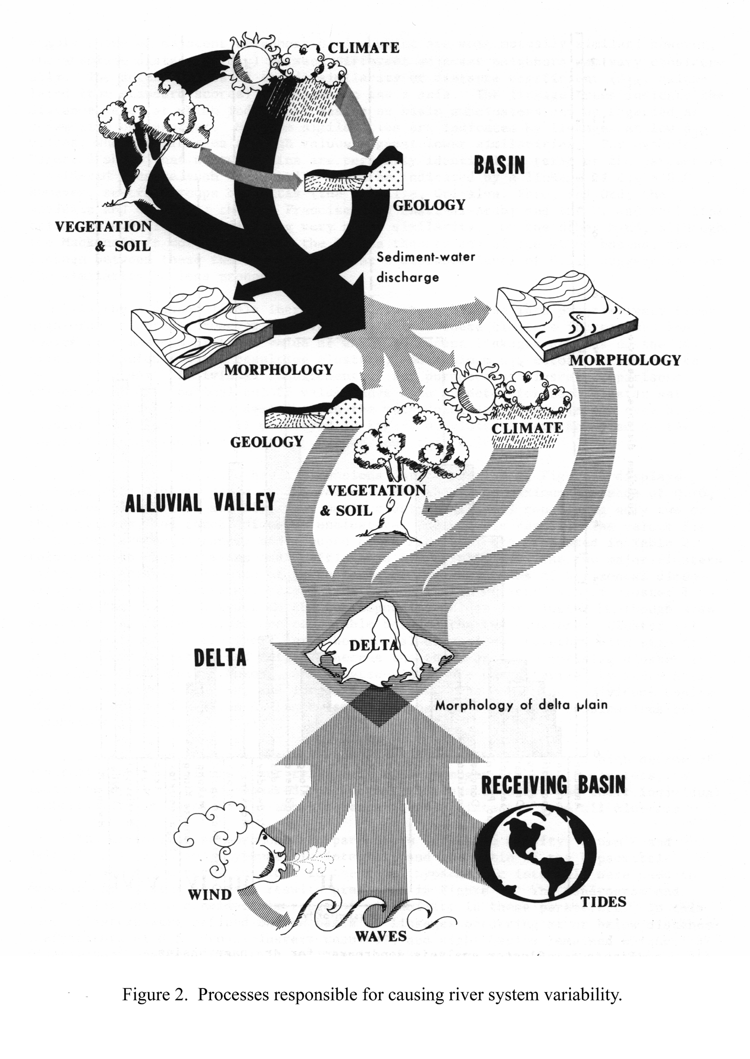
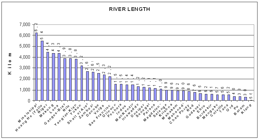
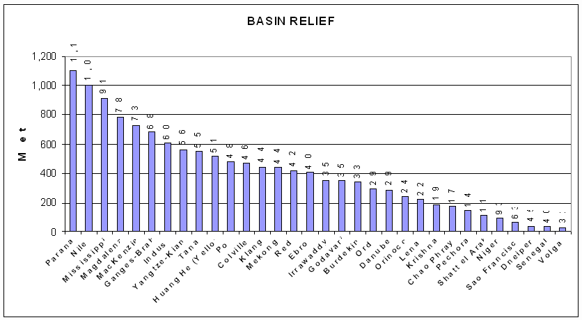
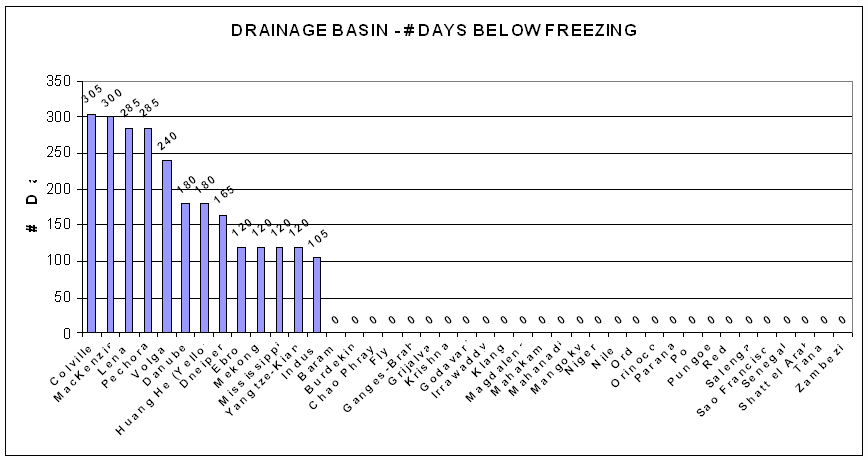
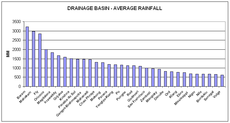
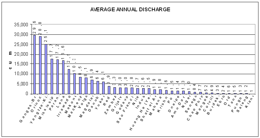
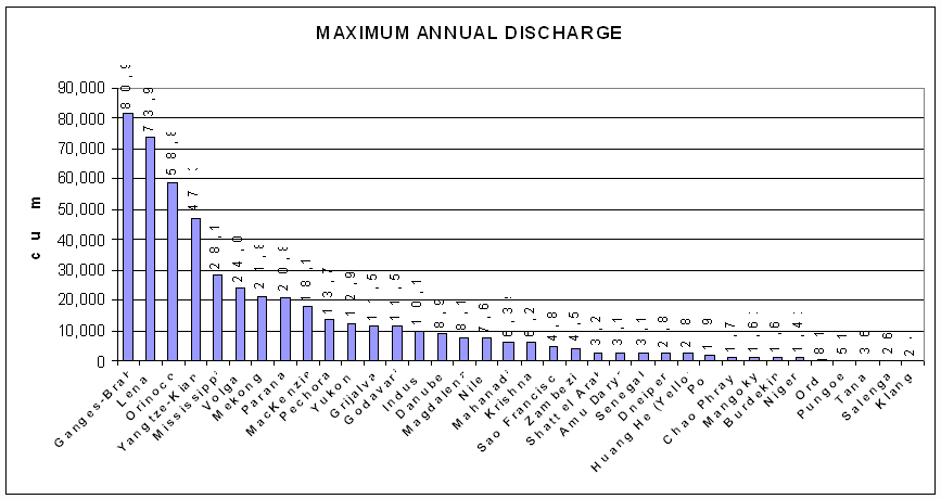
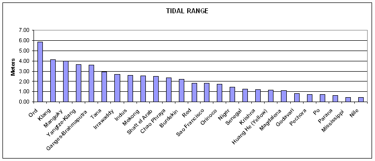
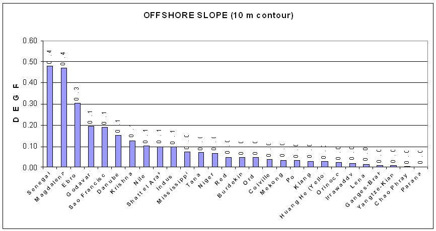
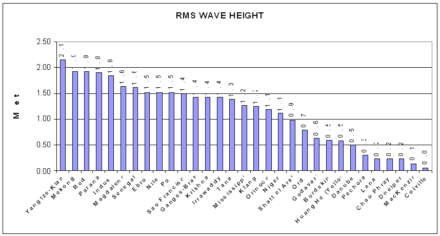
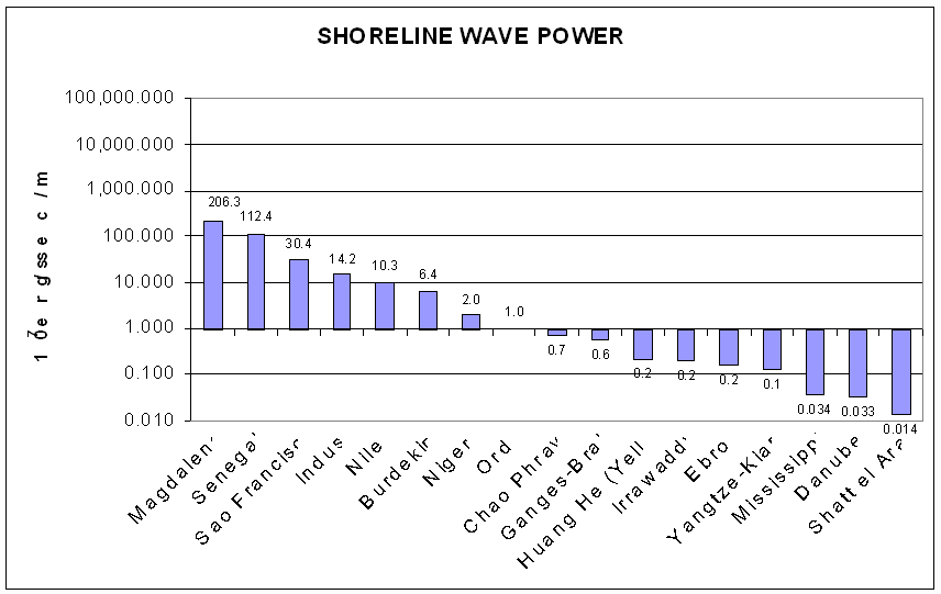
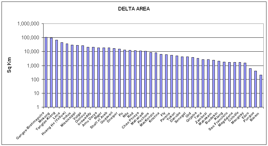
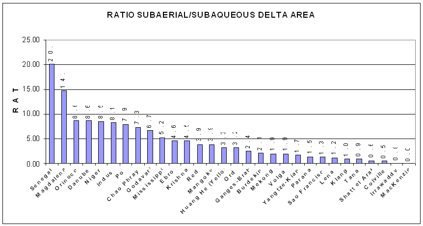
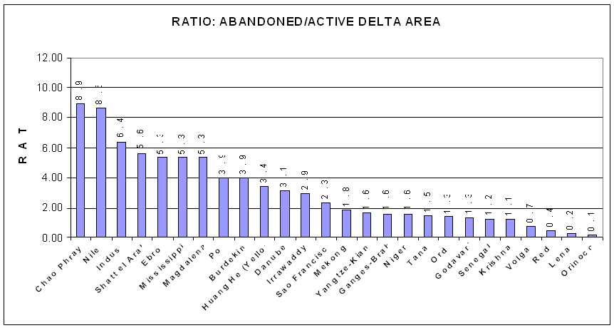
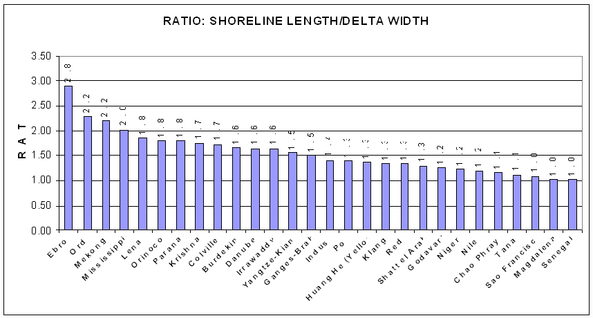
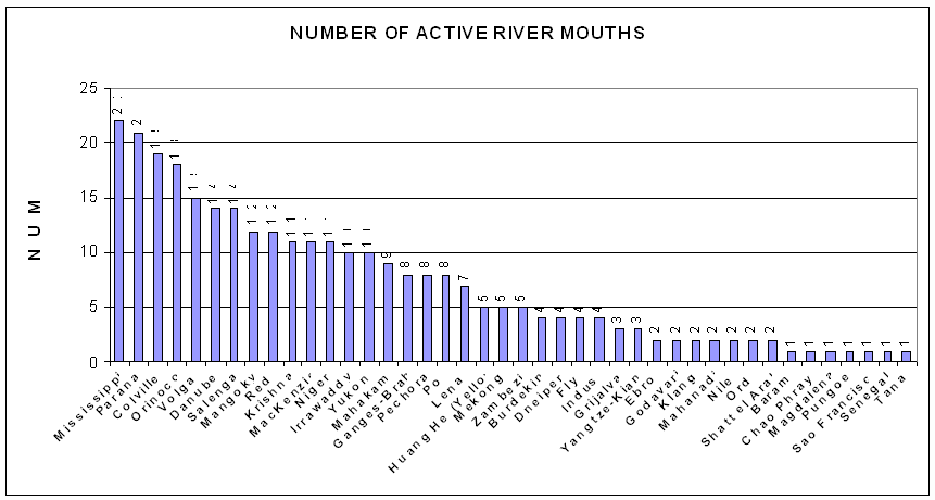
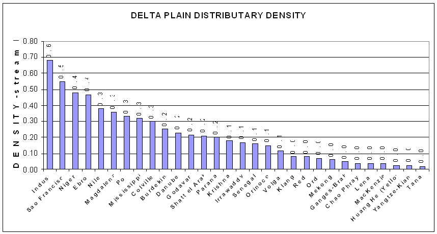
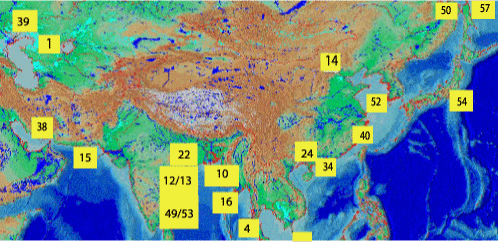