THE MAGDALENA DELTA
Delta ID # 20.
Contributed by Huh et al, 2004.
Magdalena River Delta, Colombia, South America
LOCATION LAT. 10°07’N, LONG. 74°49’W
LANDMASS DRAINED SOUTH AMERICA
BASIN OF DEPOSITION CARIBBEAN SEA (ATLANTIC OCEAN)
CLIMATE TROPICAL SAVANNA (Aw)
AIR TEMP RANGE 20°C-25°C,
TIDAL AMPLITUDE 0.6 M
TYPE SEMIDIURNAL
DISCHARGE WATER 75,000M
3/S, SEDIMENT 220X106 TONS/YR,DRAINAGE BASIN AREA 241,000 KM
2ID 7009053000101250, PATH 9 ROW 53
IMAGE ACQUIRED JANUARY 12, 2001
Geo-referenced files
Description
Contributed by Professor James Coleman, LSU. From: Coleman and Huh, 2004.

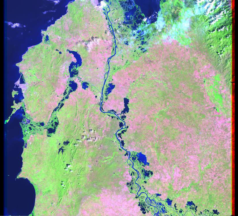
The Magdalena River, originates on the eastern flank of the Andes Mountains and flows in a northerly direction for 1,081 km (957 to the Caribbean Sea. Navigable for about 990 km upstream from the inland port of Honda to the Caribbean coast, the river is the principal route to the interior of Colombia. The headwaters of the river is located in north-south trending fold belts that range in age from Pre-Cambrian to Jurassic. The tributary density is relatively in the southern part of the basin, but becomes much denser in the northern half of the basin (Figure 58). The average tributary density is 0.67 km stream length per 500 sq km, quite high mainly because of the northern part of the basin. The average elevation in the basin is 1,088 m, with a maximum of 2,887 m and a minimum of 43 m where the alluvial valley begins. Relief in the basin is quite high, averaging 787 m. Average annual rainfall in the basin is extremely high, some 1,835 mm with a maximum of 3,266 mm and a minimum of 586 mm. Rainfall is highest during the months of April through November when the monthly average rarely falls below 150 mm. Vegetation cover in the drainage basin consists mostly of tropical and subtropical moist broadleaf forests in the southern part of the basin and tropical and subtropical dry broadleaf forests in the northern part.
The alluvial valley is well-defined, trapped between highlands on both the east and west. The river is braided for most of its length, but some meandering is found in the northern part of the alluvial valley. Numerous small lakes are found along the river coast . The average annual river discharge is 6,992 m3/sec, with a maximum of 8,141 m3/sec which occurs in June and a minimum of 4,095 m3/sec which occurs in March. Discharge is generally high all year long and the range of discharge is relatively low.
The delta is 1,689 sq km in size and is relatively small for such a large drainage basin and relatively heavy sediment discharge. The offshore slope is extremely steep, 0.47 degrees, and it is believed that much of the sediment entering the delta is funneled offshore. A relatively large submarine fan lies seaward of the continental shelf and it is possible that this accounts for the relatively small nature of the delta. The subaerial delta is some 14.8 times larger than the subaqueous delta, another fact indicating that a large part of the sediment is deposited in deep water. Most of the delta is not active, the ratio of the abandoned delta to the active delta is 5.3 and indicates that the sediments do not tend to spill overbank and create a large active delta plain. Only a single distributary is present in the delta plain, but former courses of the channel can be seen on the satellite image. Numerous lakes are present on the delta plain surface and probably are the result of former courses that have now become abandoned. The delta shoreline is relatively smooth and offshore wave power is quite high, an average of 206.25 x 10⁷ ergs/sec/m coast. Of the deltas where wave energy has been computed, the Magdalena has the highest wave power of all the deltas. The root mean square wave height is 1.62 m, again one of the highest of the deltas described. The steep offshore slope probably accounts for this high energy coast and is the reason that the shoreline is so smooth. Tides are low, averaging less than 1.0 m and little evidence of tidal activity can be seen in the satellite image. Alongshore drift of coastal sediments must be high, as a very long sandy beach fronts the delta plain and extends from the river mouth for some 68 kilometers to the highlands to the east, trapping a large lagoon behind the barrier.