A PROSPECTIVE FROM SPACE
The following introduction is from Coleman and Huh, 2004.
INTRODUCTION
Deltas vary because of variations in associated process environment. Understanding delta variability involves (1) understanding the causal links between process environment and morphologic response (deterministic studies) and (2) knowledge of the actual process environments and responses and their global associations. In order to understand the reasons for the existence of deltaic forms, the details of deterministic associations between process and form and the conditions which exist in different parts of the world must be examined simultaneously. The study of deterministic associations can lead to establishment of universal cause-effect relationships and development of theoretical models. Investigation of global variability of process environments and delta forms permits evaluation of variations in intensity of forcing agents and morphologic responses and determination of the realistic spectrum of probable process-form models.
The purpose of this paper is to present the results of a comparison of delta forms and their associated process environment. The various morphometric data presented in the report was gathered from a variety of sources and was heavily dependent on delta data acquired in the early to mid 70’s. These data were acquired under an Office of Naval Research contract with the Coastal Studies Institute, Louisiana State University. The principle investigators were J. M. Coleman and L. D. Wright. The data was published in two documents, both technical reports of the Coastal Studies Institute (Coleman and Wright, 1971 and Wright, Coleman, and Erickson, 1974).
MAJOR RIVER SYSTEMS AND THEIR SUBSYSTEM COMPONENTS
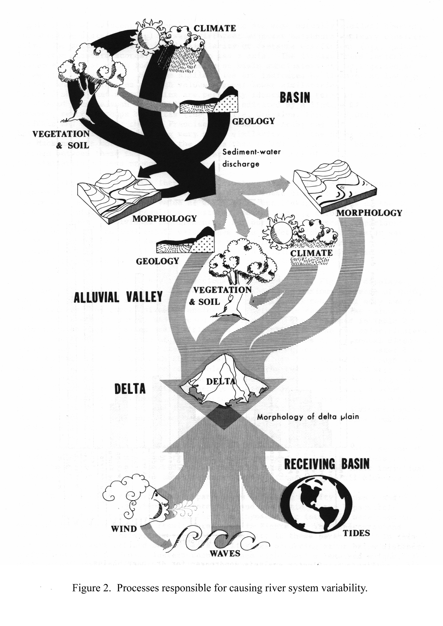
This report is concerned primarily with river deltas and their variability. However, a delta is an integral part of a larger total river system and, to be adequately understood, must be considered in that context. Each component subsystem of a river system contributes in varying degrees to the characteristics of the delta. Because of the numerous interactions which take place between subsystems, the river system as a whole is more than the sum of its parts.
Figure 1 diagrammatically illustrates the spatial relationships between the basic river subsystem. A river system consists of at least four subsystems: (1) the drainage basin; (2) the alluvial valley; (3) the receiving basin; and (4) the delta plain. Within each of these subsystems, climatic, geologic, geomorphic, hydrologic, and biologic events mutually interact. Some of these interactions are illustrated in Figure 2. The drainage basin supplies water and sediment to the remainder of the river system and is characterized by net erosion; the alluvial valley is a graded conduit which, over the long term, experiences neither significant erosion nor deposition and through which water and sediment are transported en route from the drainage basin to the sea. The receiving basin serves as a sink for the water and sediment discharged by the river and supplies energy which opposes the seaward-directed riverine energy. The delta itself is, for the purpose of this study, regarded as the response to these various subsystem contributions. The delta is characterized by sediment dispersal and accumulation and results from the interactions between riverine and marine forces.
Drainage Basin. The drainage basin, or catchment, is the source of the water and sediment ultimately supplied to the delta. The amount and temporal distribution of river discharge are of paramount importance to deltaic sedimentation and are functions of basin climate, area, and shape. The sediment yield of a basin is affected by these same factors, as well as by basin geology, relief, and hypsometry.
A total of seven different variables were measured and recorded for drainage basins and are presented for each river system described. The seven parameters are: 1) drainage basin area, 2) stream length, 3) average basin elevation, 4) average basin relief, 5) tributary drainage density, 6) number of days with below freezing temperatures, and 7) average annual rainfall. The drainage basin area was obtained by digitizing the perimeter of the basin on geo-referenced topographic maps at a scale of 1:1,000,000 and imported into a software program that was used to calculate area. Figure 3 illustrates a graph of the drainage basin areas used in this report.
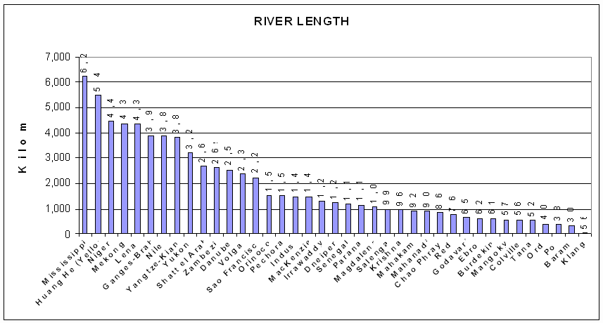
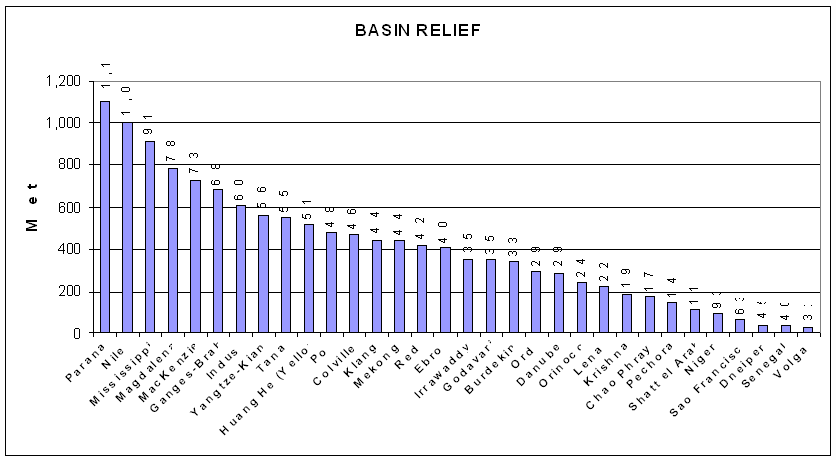
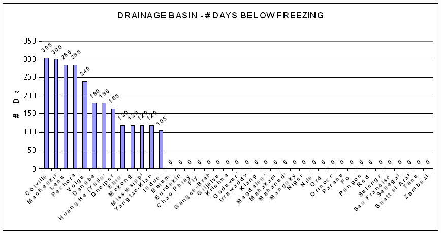
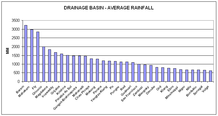
Stream length was digitized on the 1:1,000,000 scale maps and was traced from the headwaters to the river mouth outlet. Figure 4 illustrates a graph of the river lengths for the river systems analyzed. The average basin elevation was based on a random selection of elevations within the drainage basin. The number of points selected varied and no set number of points can be used to obtain an average elevation. In basins having low relief, few points are needed to determine the average, but in basins having extreme relief, a greater number of points are required. The major procedure was as follows: a) ten random points are generated and mean elevation and standard deviation are calculated, b) ten more points are randomly selected and the mean of the total (20 points) and standard deviation are calculated, and c) this process is continued until the standard deviation ceases to change significantly as additional points are measured. The number of points needed ranged from 60 to 900. Figure 5 illustrates the average elevation of the drainage basins in the river systems described. The average drainage basin relief was calculated in a similar manner to that described for calculating the average basin elevation. The relief in the vicinity of the random point is used for the calculation. Figure 6 illustrates the average basin relief for the river systems described. The drainage density is the length of the channels per unit area: Dd = ∑L/A; where ∑L is the summed length of channels per given area A in square kilometers. Drainage densities were measured at the same random points used in the relief analysis. At each point, a given area, usually 500 sq km, is blocked off and the lengths of all streams within this area are digitized. From the densities at each individual point, the mean and standard deviation are calculated. Figure 7 illustrates the drainage density for the river systems described. The number of days that the temperature is below freezing was gathered from a variety of climatic sources. Figure 8 illustrates the number of days the temperature in the drainage basin was below freezing for the river systems described. The average annual rainfall was derived from various climatic maps. Figure 9 illustrates the average annual rainfall, in mm, for each drainage basin in the river systems described.
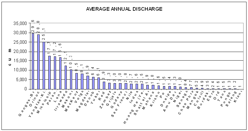
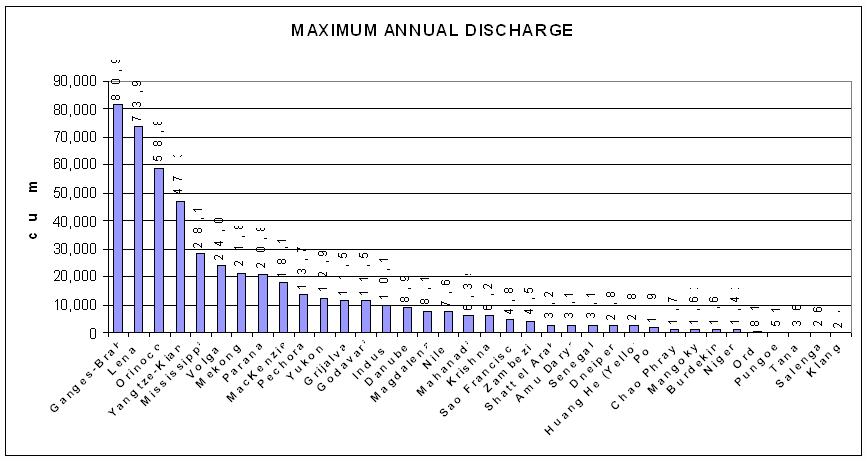
Alluvial Valley. Unlike the drainage basin, which functions as a supplier of sediment and water and experiences net erosion, the alluvial valley is approximately a balanced system in which the river flows through its own deposits. Typically, there is neither net erosion nor deposition. It is through this conduit that riverine energy, fluid, and sediment mass, derived from the drainage basin, are transmitted to the delta. Sediment sorting and trading processes, which take place within the alluvial valley, affect the texture of delta sediments. In addition, the discharge regime, which ultimately affects deltaic processes, assumes its salient characteristics and, in a sense, matures within the alluvial valley. From a practical of view, more detailed discharge data are normally available for stations within the alluvial valley. Two discharge parameters were tabulated for each river system; a) average annual discharge, in cubic meters/second, and b) discharge range, in cubic meters per second. Figure 10 illustrates the average annual discharge for each river system and figure 11 illustrates the discharge range. Although the data for river discharge came from various sources, the most comprehensive data set was found in Vorosmarty, Fekete, and Tucker (1998) and this data was used extensively throughout the document.
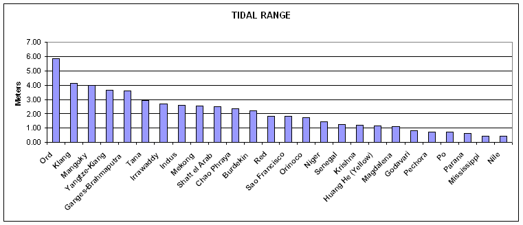
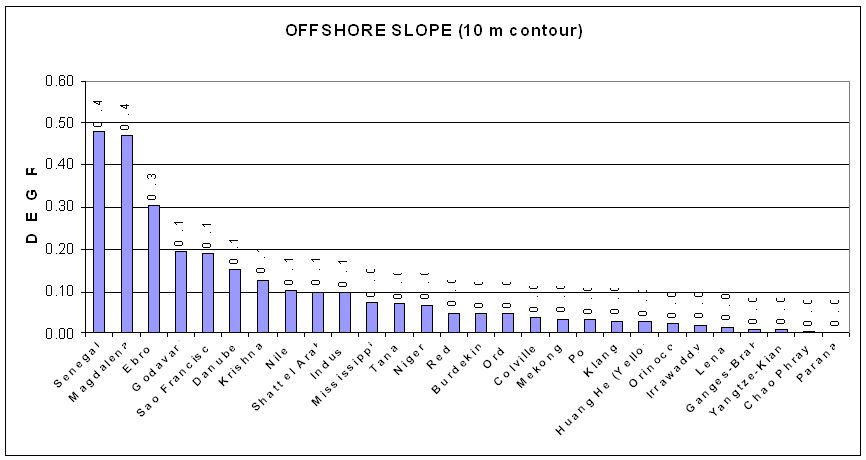
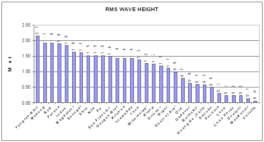
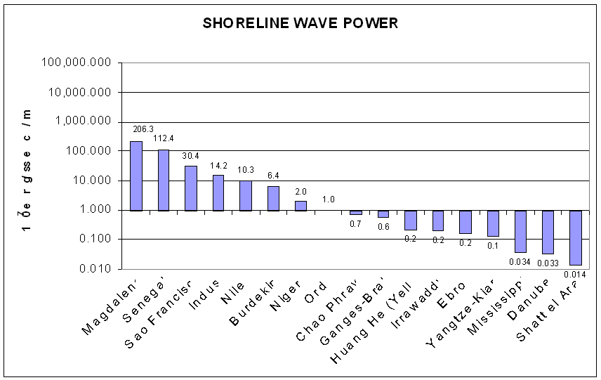
Receiving Basin. The receiving basin serves as a sink for sediments and energy discharged by the river; however, it is far from passive. In a large number of cases, marine forces play the major roles in molding the delta and determining its landscape and geometry. Of fundamental importance are the wind, wave, and tide regimes of the seas and the subaqueous morphology of the continental shelves fronting the deltas. Four parameters were computed for the receiving basins for each river system described. These parameters are: a) tidal range, b) average offshore slope fronting the delta, c) root mean square wave height, and d) wave power computed at the 10 meter contour. The average tidal range along the front of the delta was derived from a variety of sources, usually from published articles on specific deltas. Figure 12 illustrates the tidal range for each delta described. The average offshore slope (in degrees) was derived by measuring offshore profiles at selected intervals along the delta front on hydrographic maps. The average of these measurements is illustrated in Figure 13. The root mean square wave height (Hrms) was derived from a variety of sources, mostly from marine atlases. Using these data, other parameters can be calculated. Significant wave height (Hs) can be calculated using the formula: Hs = 1.416 Hrms and maximum wave height (Hmax) with the formula: Hmax = 2.366 Hrms. Figure 14 illustrates the root mean square wave height for the deltas described. Wave power calculated at the 10 meter contour offshore of the delta shoreline was based on wave height, period, and direction of incidence in deep water were determined from wind data by hindcasting procedures (Sverdrup - Munk - Bretschneider technique). These wave characteristics, together with digitized bathymetric data, were input into a computer program that calculates the effects of refraction, shoaling and frictional attenuation for any given set of wave conditions and bottom configuration. Details concerning this program can be found in Coleman and Wright (1971). Figure 15 illustrates the wave power, in 107 ergs/sec/m coastline, at the 10 meter contour for each delta in which wave data were available.
The slope and shape of the subaqueous profile fronting a delta naturally affect the rate of horizontal sediment accumulation: deltas can prograde faster across flat, shallow shelves than across steep ones. In addition, previously compiled comparisons of deltas and their associated wave-power climates (Wright and Coleman, 1971b, 1972, 1973) have demonstrated that, owing the effects of refraction and frictional attenuation, wave power which reaches the delta shoreline is as much or more a function of offshore slope as a deepwater wave characteristics.
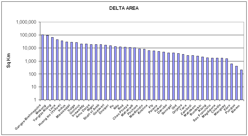
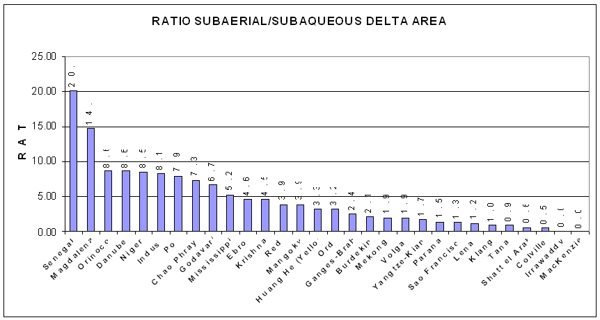
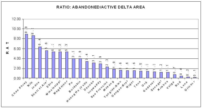
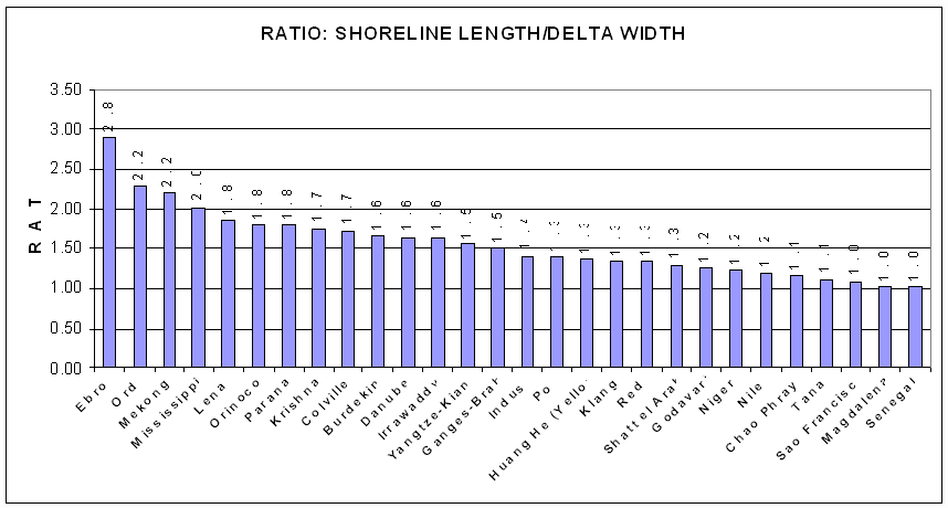
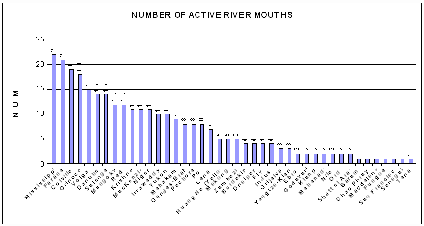
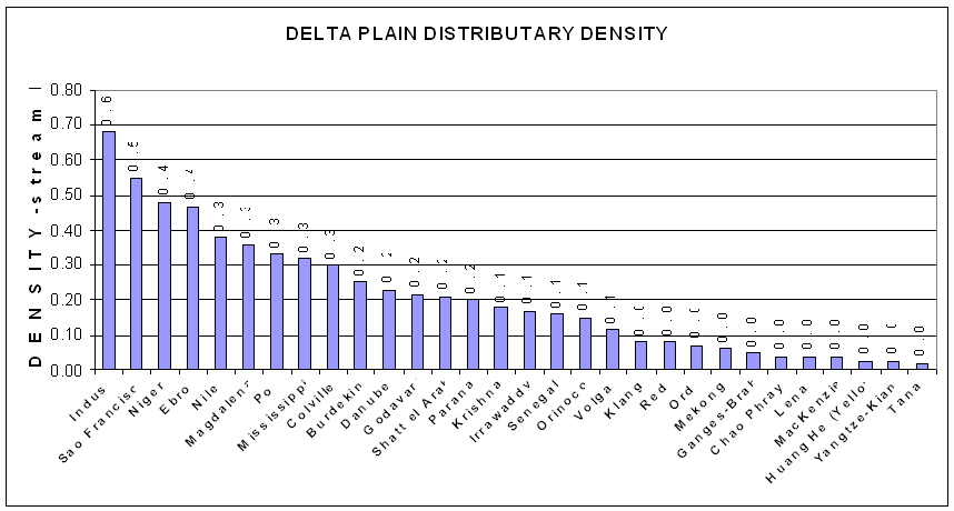
Delta Plain. The three subsystems just described all contribute to the production of the delta plain. The geometry, landforms, and environments of the delta plain and delta shoreline result from accumulation of sediments dispersed by the river and the reworking of these sediments by marine forces. Delta morphology reflects the totality of hydrologic regime, sediment load, geologic structure and tectonic stability, climate and vegetation, tides, winds, waves, density contrasts, coastal currents, and numerous other spatiotemporal interactions of all these factors. As a consequence of spatial variations in magnitudes and intensities of these factors, deltaic responses vary in terms of absolute dimensions, relative proportions of various delta components (see Coleman and Wright, 1971), distributary patterns and forms of river mouths, landform suites of interdistributary areas, and dimensionless geometry of the delta. The following variables were measured or calculated for each of the deltas described: a) delta area in sq km, b) ratio of subaerial/subaqueous delta area, c) ratio of abandoned/active delta area, d) ratio of actual shoreline length to the width of the delta plain, e) number of active river mouths, and f) distributary density. The boundary of the entire delta plain, interpreted from maps and satellite images, was digitized and the area, in sq km, was computed. Figure 16 illustrates the area of the delta plain, in sq km for each delta where data was available. The ratio of the subaerial delta plain to the subaqueous delta plain was calculated from the area of the delta plain as measured on maps and images and data derived from bathymetric maps for the area of the subaqueous delta. Figure 17 illustrates the ratio of the subaerial/subaqueous delta area. In most deltas, only a small portion of the delta plain is actively receiving and delivering sediment; the remainder of the delta plain is undergoing deterioration. These two components of the delta plain were interpreted from maps and satellite images and the boundaries of each were delineated and the area calculated. Figure 18 illustrates the ratio of the abandoned/active delta area. The ratio of the length of the shoreline to the average width of the delta is an indication of the smoothness of the delta shoreline. Those deltas with very large ratios are usually the deltas in which riverine processes are dominant, while those with very low ratios are deltas in which wave energy and currents smooth the delta shoreline. Figure 19 illustrates the ratio of the shoreline length/average delta width. The number of active river mouths was determined from examination of maps and satellite images and these data are shown in Figure 20. The total length of all distributaries in the subaerial delta plain is calculated from digitized data and this total length is divided by the total area of the subaerial delta plain to obtain the distributary density. The larger the ratio, the greater the total length of distributaries is in relation to the delta area. Figure 21 illustrates this distributary density.
DELTAIC PROCESS-FORM VARIABILITY: A BRIEF SUMMARY
The morphologic contrasts, similarities, and groupings of deltas can be attributed to corresponding differences and similarities in the process environments. However, it is typical of morpho-dynamic systems that the cause-effect relationships are bidirectional, so that the behavior of the dynamic forces in the immediate vicinity of the various deltaic forms can differ substantially from the incident, unmodified conditions. Furthermore, with a few possible exceptions, no single process subsystem (such as alluvial-valley discharge regime or receiving-basin energy regimes) can be invoked to explain deltaic patterns because all factors interact to produce the observed morphology. Attempts to demonstrate process-form relationships by inferential statistics were precluded by the small sample size, large number of important variables, and consequent insufficient degrees of freedom. An exhaustive discussion of these relationships would require a very lengthy report and in most cases, data is insufficient to make these comparisons. For more information, see Wright, Coleman and Erickson (1974). The purpose of this section is simply to summarize some of the more prominent relationships and describe the deltas as observed from satellite imagery.
The Drainage Basin and The Discharge Regime. The data indicate a direct correspondence between drainage-basin climate and size and the discharge regime of the alluvial valley; the largest and wettest basins yield the greatest discharge volume, and arid basins or basins with pronounced seasonal variations in precipitation are associated with erratic or seasonally variable discharge regimes. The actual roles of basin geomorphic factors are less obvious. Although basin morphology must certainly influence sediment discharge, the general lack of sediment data did not allow demonstration of the relationship.
Figure 22 suggests a rough tendency for the largest deltas to be associated with largest drainage basins. However, because factors such as the geologic framework of the delta and energy conditions in the receiving basin also affect the area of the delta, there is by no means direct correspondence between basin area, or even total discharge, and delta area. More important are the roles that the total discharge and discharge concentration per unit width of river mouth play in determining the degrees to which delta morphologies are river dominated or the products of marine forces. The discharge regime alone is insufficient to explain deltaic morphologic patterns; it must be considered in terms of its ability to prevail over marine forces (Wright and Coleman, 1971b, 1972, 1973). It is not
simply the strength of the river that matters, but the strength of the river relative to the strength of the opposing waves or tides of the receiving basin. Figure 23 indicates that there is a relatively good correlation between the volume of water discharged and the delta area. Those deltas that have erratic discharges are generally those that do not fit this relationship.
Near shore Marine Energy Climate And Discharge Effectiveness. Overall, the morphologic likenesses and contrasts of deltas exhibit only weak correspondence to the deepwater wave regimes of the receiving basins. This apparent lack of cause-effect association arises largely from the fact that the wave climate in the near shore region often differs substantially from the deepwater wave climate owing to wave modification by the subaqueous topography of the delta front and offshore regions. Figure 24 illustrates the relationship between waver power and average offshore slope in the delta. As can be seen in the diagram, a large amount of scatter occurs. These modifications result largely from wave refraction and attenuation by bottom friction; the significance of these effects on wave climates and resulting morphologies of deltas has been discussed in Wright and Coleman (1971b, 1972, 1973).
The morphologic similarities and contrasts among deltas show some gross tendencies to parallel the near shore wave climate spectrum. Figures 25 and 26 illustrate the near shore wave power for each delta in which data were available. The wave power is show at the 10 meter contour and the shoreline. In addition, the alongshore wave power gradients are illustrated. In general, coastal barriers and interdistributary beach ridges become more abundant, delta shorelines become straighter, and deltaic protrusions become more subdued as near shore wave power increases and as offshore slopes steepened. However, delta morphology cannot be attributed solely to near shore wave climate inasmuch as deltas result from fluvial as well as marine forces. The delta form depends on the degree to which the river is able to play the dominant role as a morphologic control. In order to index the relative delta-molding ability of river discharge, a ratio referred to as the "discharge effectiveness index" was devised (Coleman and Wright, 1971; Wright, Coleman and Ericson, 1974). This quantity is the ratio of the discharge per unit width of river mouth to the near shore wave power per unit width of wave crest. Although the absolute value of this ratio probably has little or no physical meaning, the relative values and ordering provide a highly significant means of comparing the degree of riverine dominance between deltas.
Table 1 lists 16 deltas in order of decreasing discharge effectiveness with index values normalized relative to the maximum. The Mississippi Delta has the largest discharge effectiveness (normalized value of 1.0) and is consequently the one most dominated by the river, whereas the Senegal Delta exhibits the lowest value (normalized value of 5.99 x 10⁻⁵) and is thus the one most dominated by waves. Delta morphologies define a broad range of patterns between the two extremes. At the river-dominated (high discharge effectiveness) end of the spectrum, deltas are highly indented and have extended distributaries and extensive marshes, bays, or tidal flats in interdistributary regions. With increasing near shore wave power and decreasing discharge effectiveness, delta shorelines tend to become more regular, and gentle, arcuate protrusions and beach ridges become more common. The highest near shore wave-power values and lowest discharge-effectiveness indices are associate with deltas which exhibit wave-straightened shorelines and abundant beach ridges.
Table 1
Discharge Effectiveness of Sixteen Rivers
Index#9
Mississippi…………..1.00 Indus………………..1.10 x 10-2
Shatt el Arab…………6.98 x 10⁻¹ Ord…………………3.66 x 10⁻³
Danube………………2.14 x 10⁻¹ Burdekin……………2.08 x 10⁻³
Amazon………………1.17 x 10⁻¹ Chao Phraya………..1.77 x 10-3
Ebro………………….4.87 x 10-2 Niger………………..8.03 x 10-4
Hwang Ho……………4.16 x 10⁻² Nile…………………5.86 x 10⁻⁴
Irrawaddy…………….1.70 x 10-2 Sao Francisco……….2.37 x 10-4
Ganges-Brahmaputra…1.12 x 10⁻² Senegal……………...5.99 x 10-5
Despite the generalities just discussed, wave and discharge regimes alone do not explain the entire range of deltaic landscapes, particularly under extreme conditions of climate, tide range, or subsidence rate. Deltas in macro-tidal environments are characterized by abundant tidal flats and tidal creek networks in their interdistributary areas. Climatic effects are equally significant: those deltas with abundant swamps or other interdistributary vegetation tend to occur in humid environments, whereas arid delta climates are associated with barren evaporite flats. Numerous thaw lakes are common in arctic deltas.
River-Mouth Process-Form Variability. The forms of river mouths and lower river courses also exhibit a broad range of variability. Comparisons tend to suggest that river-mouth morphology reflects differences in the relative importance of the mechanisms of effluent buoyancy, inertia, bottom friction, and bi-directional bottom shear. The intensities of these effects are, in turn, dependent on the sharpness of water-density contrasts at the river mouth, the depth and slope of the bottom fronting the river mouth, and the tidal range and strength of tidal currents. Investigations at the mouths of the Mississippi River have suggested that flow tendencies associated with the expansion of buoyant effluents may be responsible for maintaining straight, parallel distributary levees and high depth-width ratios. These buoyant effects are dominant when the tidal prism is minor relative to river discharge, allowing salt wedges to intrude into channels without appreciable tidal mixing. This type of river-mouth system characterizes the Mississippi, Danube, Po, and Magdalena Rivers. The effects of bottom friction play a major role in controlling effluent expansion and deceleration when outflow velocities are high relative to water depths in and immediately beyond the outlet. Under these conditions, the river-mouth effluents expand and decelerate more rapidly, producing distributary levees which diverge downstream and middle-ground-type bars. River mouths in macro-tidal environments tend to experience strong bi-directional flow and appreciable tidal mixing, which obliterates vertical density gradients. These river mouths characteristically exhibit downstream bank divergence at exponential rates and linear tidal ridges in and seaward of the mouths. The mouths of the Ord, Shatt-al-Arab, Chao Phraya, and Irrawaddy Rivers fall into this general category.