THE MAHANADI DELTA
Delta ID #2 2.
Contributed by Huh et al, 2004.
Mahanadi River Delta, India, Asia
LOCATION LAT
. 20°13’N, LONG. 86°34’ELAND MASS DRAINED INDIAN SUBCONTINENT
BASIN OF DEPOSITION SOUTH CHINA SEA
CLIMATE TROPICAL SAVANNA
(Aw)AIR TEMP RANGE
20°C TO 35°C,TYPE OF TIDE SEMIDIURNAL
ID
7139046000204650, PATH 139 ROW 46
IMAGE ACQUIRED FEBRUARY 15, 2002
Delta type:

IMAGE ACQUIRED
Geo-referenced files
Description
Contributed by Professor George F. Hart, LSU. From: Hart 1999.
Photographic album of Mahanadi Delta slides.
In the region of the Mahanadi River the climate is predominantly sub-tropical with summer temperatures of around 29oC and winter temperatures of 21oC. The bulk of the precipitation is in the July to September period [800 to over 1200 mm] with January to February precipitation of less than 50 mm.
The drainage basin
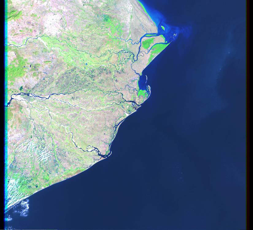
The Mahanadi River commences in southeastern Madhya Pradesh as a small stream draining the eastern part of the Chhattisgarh Plain. It enters Orissa State below Baloda Bazaar and crosses the eastern Ghats to enter the Plains of Orissa near Cuttack and finally debouch into the Bay of Bengal through a series of channel ,after a 900 km journey. The Hirakud Dam forms a 55-km long lake. The famous city of Puri is at one of the distributary mouths.

Drainage density is extremely dense (Figure 60, from Coleman and Huh, 2004.]. The area of the drainage basin is 141,464 sq km. The interior coastal plain has a relatively low elevation and relief is extremely low. The average elevation of the drainage basin is 426 m, with a maximum of 877 m and a minimum of 193 m.
The upper part of the deltaic plain is heavily populated with a density exceeding 36 people per sq. km, although the frontal part of the delta is much less so. Rainfall is dominated by the summer monsoon [ June through September] with an average annual rainfall in the basin is 1,463 mm [ 1,663 mm - 1,331 mm]. The remainder of the year, rainfall is extremely low, rarely exceeding 30 mm per month.
"The alluvial valley is poorly defined and the channel is predominantly meandering in nature. The average annual discharge is 1,895 m3/sec, with a maximum of 6,352 m3/sec during the summer monsoon. Minimum discharge is 759 m3/sec and occurs during the months October through June. The river is one of the most active silt-depositing streams in the Indian subcontinent. The area of the delta is 10,589 sq km. The delta is extremely complex with numerous abandoned delta lobes (Plate 21). The presently active delta lobe lies to the south (Plate 21) and at least two other abandoned delta lobes are located to the north as can be seen in the image. The obviously older delta lobe to the north is now dominated by tidal influence and numerous tidal channels are apparent on the image. Mangrove is the most common type of vegetation along the seaward edges of the delta plain. The delta plain is a major rice-growing region in India and population density is extremely high. Numerous lakes and bays are present on the delta plain, many of them the remnants of former river courses. Wave energy is quite high along the delta front and well-developed beaches and barrier islands are present along the coast." [Coleman and Huh, 2004.]