 . It is the area of Clark Creek near the city
of Pond.
. It is the area of Clark Creek near the city
of Pond.TOPOGRAPHY
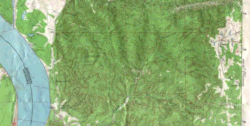
What you see below is a topographic picture of:. It is the area of Clark Creek near the city
of Pond.
This is a topographic map, which says that the diferent levels of height are shown. You can see the Mississippi River to the Western side of it. Clark Creek is a small channel that extends off to the side of the river. This is where our class went to spend our Saturday in September. The area itself is full of hills, as well as valleys and straight bits of land that range anywhere from 400 feet above sea level to 100 feet above sea level. The highest point of the area is off to the side of the small road that leads up to the parking lot where our treacherous journey began. The lowest point is located on the floor of the creek itself, a mere 100 feet above sea level. Our trek started off rough, as we went down nearly 200 feet in less than half a mile, not to mention the twists and turns throughout. It wasn't all straight down, though. We witnessed a formation known as a divide, where we passed safely over a higher strip of land while looking over both sides to see a deadly 150 to 200 foot drop on either! Whooa!! The divide was only about 10 or 15 feet wide. By the time we got to the bed of the creek itself, the change in height was obvious. The floor was usually a steady 100 feet above sea level, but there were places where cliffs rose up 100 feet on both sides, and all very straight, as well as jagged. We continued on our hike, and we eventually passed a total of 4 beautiful waterfalls, ranging from 16 to 25 feet high. When we got to the last waterfall, we stopped and did our work, taking pictures, collecting samples, and fighting off poisonous snakes. On the return trip we made a few more observations about several cliffs, some jagged, some steady, and pointed out where certain rocks had been cut away and the land left open to erosion. The walk back up the big hill was a nightmare, because we had to go from 150 feet to about 300 feet in less than a mile, and all over smooth, gripless soil. When we got back, we ate cookies and sandwiches and came back home. Whew! What a trip!
Here's the scale for the entire area: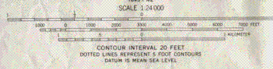 It's cut off at the vey end, but that's OK, because that
IS the end.
It's cut off at the vey end, but that's OK, because that
IS the end.