THE VOLGA DELTA
Delta ID # 39.
Contributed by Huh et al, 2004.
LOCATION LAT
. 46°01’N, LONG. 49°02’ELANDMASS DRAINED RUSSIA
BASIN OF DEPOSITION CASPIAN SEA
CLIMATE DESERT
(BWk)AIR TEMP RANGE
-0.4°C TO 16.5°CID
7168028000127850, PATH 168 ROW 28
IMAGE ACQUIRED OCTOBER 5, 2001
Delta type:
Description
Contributed by Professor James Coleman, LSU. From: Coleman and Huh, 2004.

The Volga River, the largest river system in Europe, rises in the Valdai Hills northwest of Moscow at an elevation of 225 m and flows through its 2,365 km length to discharge into the Caspian Sea. It has a drainage area in excess of 1,553,900 sq km. Over much of this drainage area, the river traverses a broad, often swampy basin, surrounded by low morainic hills. Within its basin lives nearly 25 percent of the total population of the U.S.S.R., and the river and its tributaries carry about two-thirds of all the river borne freight in the country. The eastern boundary of the drainage basin lie in the Ural-Novaya-Zemblya fold belt, while the central part of the basin contains the Moscow basin. The western edge of the drainage basin is bounded by the Baltic shield. Most of the basin drains Paleozoic and Mesozoic sediments. Earthquakes are common along the eastern edge of the drainage basin. Tributary density is quite (Figure 85) and numerous small tributaries enter the main channel of the river. The average elevation in the drainage basin is 161 m, with a maximum of 783 m and a minimum of 30 m. Relief is quite low within the basin, averaging only 32 m. The average annual rainfall is 626 mm, with a maximum of 839 mm and a minimum of 395 mm. The wet months are July through August and the basin has some 240 days with temperatures that are below freezing. Discharge during these periods is extremely low. Boreal forests and taigas cover most of the drainage basin.
The alluvial valley of the Volga River is well-defined and displays a meandering pattern [39-i02]. More than 200 tributaries merge with the main river, including the Kama, Samara and Oka. Today, much of the flow is regulated through a series of dams and reservoirs. The Volga is fed mainly by snowmelt. Average annual river discharge is 8,103 cu m/sec with a maximum of 24,022 cu m/sec and a minimum of 3,918 cu m/sec. High discharge is in May and June and low discharge is from August through March. Prior to damming, the river delivered 25.5 million tons of suspended sediment and an unknown quantity of bedload to the Caspian Sea (Zenkovich, 1967).
The Volga River flows into the Caspian Sea, the earth’s largest landlocked water body, and its isolation from the world's oceans has enabled the preservation of several unique animal and plant species. The Volga provides most of the Caspian's fresh water and nutrients, and also discharges large amounts of sediment and industrial waste into the relatively shallow northern part of the sea.
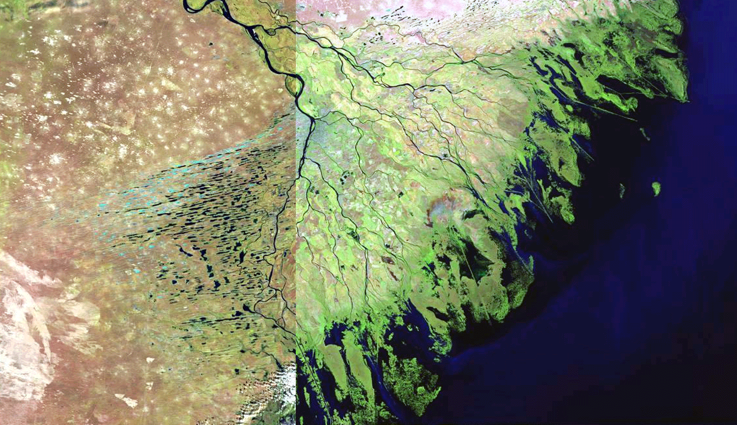
The delta has a classical "delta pattern" [39-i01] and comprises an area of 27,224 sq km. It has both a well developed subaerial and subaqueous delta components. The ratio of the subaerial delta to the subaqueous delta is 1.97. The river system can be described as an erratically discharging river, flowing into a receiving basin whose water level has varied consistently during the Recent. Within the receiving basin, wave and current energy is extremely low. The level of the Caspian Sea has been fluctuating significantly, and in the last 150 years, water level has fluctuated over 6 m; during the period 1930 to 1963, water level dropped 2.6 m. This water-level fluctuation has led to three zones in the delta proper. The higher areas of the first zone are referred to as "Behr's mounds," linear ridges of clayey sands ranging from 400 m to 10 km in length and averaging 8 m in height (oriented lake regions to the west of the delta in Plate 38). Between the ridges are elongated depressions (ilmens in Russian) that fill with water and become either fresh or saline bays. It is believed that these ridges and swales represent coastal banks now stranded by the falling level of Caspian Sea. The delta proper, comprising the second zone, displays low relief (generally less than 1 m) and is the site of active and abandoned channels, interdistributary regions (often containing saline water), small dunes and algal flats, and small, partially vegetated eolian dunes that derive their sediment from the exposed dry channel courses. The third zone is the submarine part of the delta, which forms a broad platform extending 30 to 60 km offshore.
The main eastern distributary, the Sumnitsa, enters the delta north of the city of Astrakhan and immediately forms a complex anastomosing channel pattern consisting of numerous dry and abandoned channels, as well as active channels. Flow in the channels is so erratic that, for much of the year, little or no water flows in the channels. Strong winds erode the channel floors and form linear dunes on the overbank areas. Adjacent to the main channels are well-developed natural levees, capped with small eolian dunes; the source of the sand is the adjacent channel. The active channels that contain river flow are ice bound during the period December through March. Before the construction of dams, these complex channels constantly shifted their position with each flood.
North and west of the delta are broad coastal dunes, many of which have been stranded inland by the falling level of the Caspian Sea. Many of these show little or no orientation and are generally devoid of substantial vegetative cover. A similar extensive system bounds the western flank of the delta, in which inter-dune areas enclose elongate, oriented lakes (Plate 38). The sand ridges have been stranded by the falling level of the Caspian Sea and consist of marine sands reworked by eolian action; they generally contain a high shell content.
In the lower delta, the small distributaries display well-developed, complex, bifurcated channel patterns, and because of this process, the few major distributaries that enter the head of the delta have split, producing more than 80 active river mouths in the delta. Plate 38 shows the complex distributary channel patterns of the river mouth and the adjacent mudflats. At the river mouths, many shoals and triangular river-mouth bars (called middle ground shoals in the Mississippi River delta) are the most common geomorphic landform. Relief is very low, rarely exceeding 0.5 m. Immediately offshore is another complex system of subaqueous channels and shallow shoals that forms the delta-front platform. Because of their small size, most of these are barely visible in the image. All along the front of the delta, mudflats, coquina banks, and muddy sand shoals are present, associated with the rapid progradation of the channels before damming. On the lateral margins of the delta are algal flats and salt pans which have accumulated in those parts of the delta that are no longer active or in depressions that have been stranded by the falling level of the Caspian Sea.
Because of the changes in the level of the Caspian Sea, the delta has grown significantly in the past century. Figure 86 illustrates the growth of the delta from the period 1880 to 1991 (Alekseevskiy, Aibulatov, and Chistov, 2000). In 1880, the delta had an area of 3,222 sq km and by 1920, an additional 2,970 sq km had been added as a result of the falling level of the Caspian Sea. From the period 1920 to 1991, an additional 6,580 sq km of subaerial delta had been deposited.

In order to determine the short-term changes in open water and conversion of wetlands to agricultural and industrial use, images acquired in 1984 and 2001 were analyzed for change detection. In 1984, a total of 397,677 acres of open water existed in the Volga River delta plain. This represented 10.6 percent of the delta plain that contained open water. Some 17 years later, in 2001, a total of 441,708 acres of open water existed in the delta plain, a loss of 44,031 acres of wetlands and now nearly 12 percent of the delta plain is open water. During this same period of time, new wetlands were being formed, but only 19,279 acres were deposited during the 17 year period. Thus subsidence and other natural factors resulted in a net loss of wetlands on the order of 24,752 acres. The rate during this period of time averaged 1,456 acres per year. Industrial and agricultural modification to the delta plain has also resulted in significant wetland loss. In 1984, 230,006 acres of delta plain were used for agricultural or industrial use. This represents roughly 6 percent of the original wetlands that existed in the delta. By 2001, a total of 273,680 acres of the delta plain had been modified by man, an increase of 43,674 acres during the 17 year period . Thus, in a 17 year period, a net loss of delta plain wetlands by natural causes and man-induced causes has been 68,426 acres and the loss is occurring at a rate of 4,025 acres/year.

Overlay of historic Delta Margin showing changes of the system.