THE PECHORA DELTA
Delta ID # 31.
Pechora River Delta, Russia, Asia.
LOCATION LAT. 68°16’N, LONG. 52°20’E
LANDMASS DRAINED RUSSIA, EUROPE
BASIN OF DEPOSITION BARENTS SEA
CLIMATE TUNDRA (ET)
AIR TEMP RANGE -27.4°C – 9.2°C,
TYPE OF TIDE SEMIDIURNAL
ID 7175012000018150, PATH 175 ROW 12
IMAGE ACQUIRED JUNE 29, 2000
Geo-referenced files
Description
Contributed by Professor James Coleman, LSU. From: Coleman and Huh, 2004.

The Pechora River rises in the Ural Mountains of northern Siberia and is the largest river debouching into the Barents Sea. The eastern part of the drainage basin lies in the Paleogene and Mesozoic sediments of the Ural - Novaya - Zemblya Fold belt. The central part of the basin lies within the Timan-Pechora basin and is composed of Mesozoic sediments. Along the western edge of the basin is the Timan High, composed of PreCambrian sedimentary rocks. The drainage basin is relatively small, covering some 300,700 sq km. The main channel has a river length of 1,513 km and is predominantly braided throughout its length. The climate is primarily arctic in nature and there is an average of 285 days when the basin temperature is below freezing. The average annual rainfall is 484 mm, with a maximum of 700 mm and a minimum of 379 mm. The rainy months are few and last from mid July through September. The average basin elevation is 154 m with a maximum of 927 m and a minimum of 53 m. Tributary drainage density is moderate (Figure 75), the average being 0.21 km stream length per 500 sq km. Insular permafrost occurs throughout most of the basin and thickness of the ice layers range from several meters to several tens of meters. For some 285 days of the year, the temperature in the drainage basin is below freezing. Vegetation in the central and western parts of the drainage basin is primarily composed of Boreal forests and taigas.
The alluvial valley is well defined and the river displays a braided pattern along most of its length. The average annual river discharge is 3,411 cu m/sec with a maximum of 13,760 cu m/sec in the month of May and a minimum of 481 cu m/sec in the month of March. During the winter months, from November to April, flow is reduced considerably. Within a few days, the river discharge will go from 700 cu m/sec to 8,900 cu m/sec during the breakup. The major channel displays a braided course throughout most of its length.
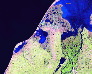
The modern delta is depositing its sediment load and infilling a narrow structural embayment, so the delta is not free to shift its course. The delta has an area of 8,737 sq km and the distributaries form a maze of anastomosing channels. The most active portion of the delta is in the northern part of the plain and this main tributary is actively depositing sediment through a narrow gap in the structural embayment . Numerous thaw lakes dot the delta plain and occupy the majority of the interdistributary area. The subaerial delta is much larger than the subaqueous and most of the delta plain is presently active. It is apparent that the southernmost distributaries are diminishing in size as there is little room for them to prograde. Offshore wave active is virtually absent and thus few beaches exist in the delta proper. Ice polygons are present in the regions between the numerous lakes.