THE YANGTZE KIANG DELTA
Delta ID # 40.
Contributed by Huh et al, 2004.
Yangtze River delta, China, Asia
LOCATION LAT. 31°44’N, LONG. 121°52’E
LANDMASS DRAINED CHINA, ASIA
BASIN OF DEPOSITION EAST CHINA SEA, PACIFIC OCEAN
CLIMATE HUMID SUBTROPICAL (C
af)AIR TEMP RANGE -0.4°C – 30°C,
TIDAL AMPLITUDE 3.8 M
TYPE SEMIDIURNAL
DELTA AREA 40 000 KM
2DISCHARGE SEDIMENT 470X10
6 TONS/YR,ID 7118038000118450, PATH118 ROW 38
IMAGE ACQUIRED JULY 3, 2001
Delta type:

Geo-referenced files
Description
Contributed by Professor James Coleman, LSU. From: Coleman and Huh, 2004.

The Chang Jiang or Yangtze is the longest river in China. It originates in the Tibetan highlands province on the southern flank of the Kunlun Mountains of southwestern China. The river's course takes it from the Kunlun Mountain region (elevation approximately 5100 m) to the East China Sea through variable terrain for a total length of 3,807 km (for the main river). The Yangtze drainage basin, which extends over 1,354,200 sq km, can be roughly divided into two sections. Rugged mountain terrain is characteristic of the western part, which lies within and south of the Szechwan Basin of west China where the main river has its source. It flows through valleys and spectacular steep-sided gorges for 3,790 km before it encounters a vast alluvial plain beginning some 950 km from the coast. The average elevation in the drainage basin is 748 m, with a maximum of 3,680 m and a minimum of 30 m. Relief is relatively low in the drainage basin, the average being only 567 m. Drainage density is quite high, averaging 0.36 km stream length per 500 sq km and numerous lakes are present along the tributaries (Figure 87). For approximately 120 days during the year, the tributaries are frozen and little or no flow from theses northwestern channels is present. The average annual rainfall is quite high, being 1,190 mm with a maximum of 1,917 mm and a minimum of 572 mm. The rainy months extend from April through September and average over 150 mm per month. The dry season extends from October through March and monthly rainfall averages only 50 mm per month.
This alluvial area is one of the most fertile and populated regions of China. The river is fed primarily by snow-melt in the upper 75 percent of its course. Because of the narrow river valleys and erratic discharge, river stage can rise rapidly (as much as 10 m/day). The stage ranges between 20 and 30 m, but sometimes reaches a maximum of 40 m. Average annual discharge is 25,110 cu m/sec at the head of the delta, with a maximum of 47,300 cu m/sec (July) and a minimum of 9,261 cu m/sec (February).
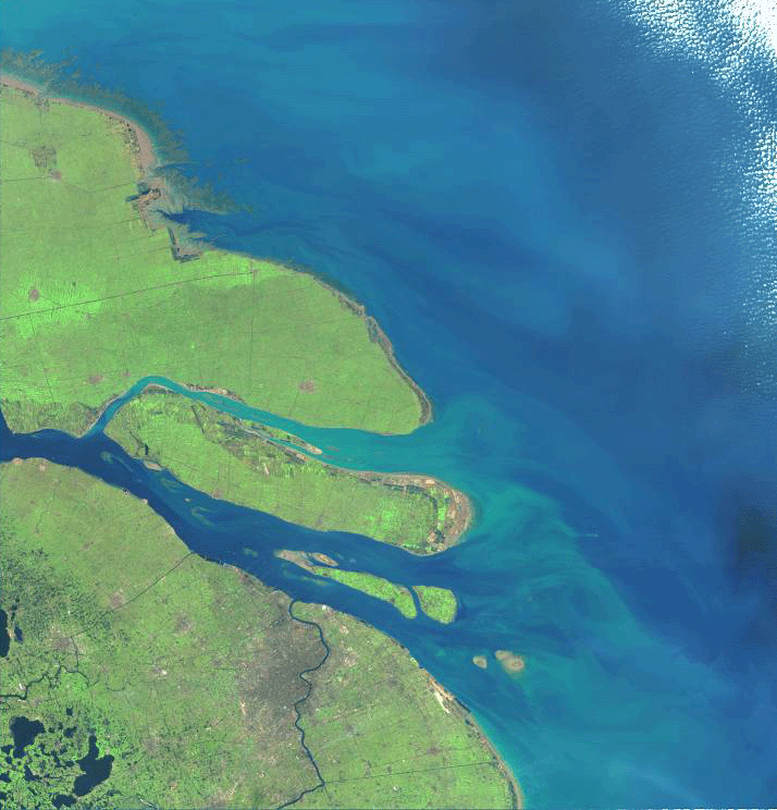
The Yangtze is building a delta that is prograding into the East China Sea at an estimated rate of about 2 km per century. The delta has an area of 66,669 sq km. In most delta classifications, the Yangtze would be categorized as a tidally dominated type because it has a semidiurnal tide of 3.7 m. Like other deltas (e.g., Shatt el Arab) that are exposed to low levels of wave energy, but are building into basins with a high tide range, the channel mouths display a bell-shaped pattern (Plate 39). Wave power is extremely low, the average wave power at the shoreline is 0.127 x 10⁷ ergs/sec/m coastline. The root mean square wave height is 2.14 m. Other features common to deltas that are shaped mainly by tidal forces are the elongate sandy tidal bars within the bell-shaped mouth, tidal flats that fringe the coast, and lineated sediment plumes [40-i01]. The tidal flats, as well as the subaerial coastal plains, are cut by numerous tidal channels, but are often obscured by agricultural practices. Because of the incredible demands on the subaerial parts of the lower delta to support a massive population, the surface is a maze of intersecting canals, many of which serve the triple purpose of drainage, irrigation, and transportation. The speckled pattern that occurs over the entire subaerial delta [40-i01 and 40-i02] represents inhabited and cultivated areas segregated by a network of manmade canals and a few natural channels.
The Yangtze River discharge is about 22,000 cu m/sec at its mouth. Associated with this discharge is a heavy load of silt. It is estimated that more than 142 million cu m of sediment pass down the Yangtze every year. Although subsidence is taking place in the delta, deposition occurs at a more rapid rate, and thus the river mouths prograde rapidly. As sedimentation continues in the delta, reclamation dikes are built that contain sluice gates to allow inflow during flood tide and the settling out of mostly silt- and clay-sized particles. Much of the coastline along the northern flank of the delta, as well as in the main channel, has actually been built by man's intervention. The effects of active reclamation projects along the northern flank of the delta are readily surmised from the geometric appearance of this coast, as seen in Plate 39. Land recently reclaimed by this process is now under extensive cultivation and habitation. Coastal protection with seawalls and rip-rap is widely used to preserve the coastal beach and agricultural lands from both marine and fluvial erosion. These areas are dominated by tidal processes. Only the southern flank of the delta maintains the balance between wave action and sedimentation to create active but narrow beaches. The remainder of the coast is fronted by tidal flats and tidal bars.
The combination of rich lower deltaic plain sediments, a hot wet summer, and a shallow water table leads to heavy cropping. Rice is by far the most important summer cereal. Other summer crops are cotton, soybeans, and corn. Rice is grown in rotation with winter wheat. Not only does the lower delta serve as an important agricultural area, but also the entire alluvial plain, which extends inland some 900 km.