THE SHATT-AL-ARAB DELTA
Delta ID. # 38.
Contributed by Huh et al, 2004.
Shatt Al-Arab River Delta, Iraq, Asia
LOCATION LAT. 30°18’N, LONG. 48°53’E
LANDMASS DRAINED ASIA (IRAQ).
BASIN OF DEPOSITION PERSIAN GULF
CLIMATE SUBTROPICAL STEPPE (BSh)
AIR TEMP RANGE 9.3°C TO 40.4°C
TIDAL AMPLITUDE 2.8 M
TYPE SEMIDIURNAL
DISCHARGE WATER 14,000M
3/SDRAINAGE BASIN AREA 1.114X10
6 KM2ID 7165039000103350, PATH 165 ROW 39
IMAGE ACQUIRED FEBRUARY 2, 2001
Delta Type
Description
Contributed by Professor James Coleman, LSU. From: Coleman and Huh, 2004.

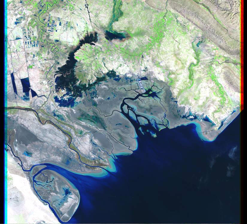
The Shatt el Arab river rises in the Tertiary and Mesozoic northwest-southeast trending Zagros fold belt. The river is formed by the confluence of the Tigris and Euphrates Rivers, which flow through central and eastern Iraq. A third river, the Karun River, which rises in west-central Iran and drains the Zagros mountains joins the Shatt el Arab just north of the modern delta. The Tigris/Euphrates Basin, as well as its extension, the Persian Gulf, occupies a zone of subsidence flanked by mountains and/or desert. This elongate depression was formed during an era of mountain building initiated early in the Tertiary that continues with the movement of the Arabian plate against the stable landmass of Asia. The drainage basin of these three rivers covers an area of 793,600 sq km. The main channel is some 2,658 km long and debouches into the Persian Gulf. Tributary density is quite low (Figure 84) and the average tributary density is 0.01 stream length per 500 sq km. The average elevation in the basin is 1,090 m, with a maximum of 2,450 m and a minimum of 60 m. Most of the drainage basin is covered with desert and xeric shrubland, with some temperate coniferous forests in the northeastern part of the basin. The average annual rainfall is 920 mm, with a maximum of 1,921 mm and a minimum of 599 mm. The wet months begin in June and end in November, but the monthly average rainfall during this period rarely exceeds 100 mm. During the dry months, December through May, there are many months that have no rainfall and the average monthly rainfall rarely exceeds 50 mm.
The alluvial valley of each of the three rivers are fairly well defined and the channels display a meandering tendency, with stretches of braiding where tributaries enter the main channels. The average annual river discharge is 1,966 cu m/sec with a maximum of 3,299 cu m/sec and a minimum of 849 cu m/sec. The delta exists today in an arid climate, with extremely high rates of evapo-transpiration and notable fluctuations in temperature and wind, controlled mainly by topographic variations outside the delta. The Shatt el Arab delta is located at the northern end of an elongate shallow sea where semidiurnal tidal variations reach about 2.5 m. Although much of the delta is made up of broad marshes and associated lowlands that are valuable as agricultural lands, most coastal regions are tidal flats and sabkhas devoid of extensive vegetation where salts are deposited [38-i01]. Darker areas that border the bell-shaped river mouths and tidal channels on the image correspond to fine-grained sediment deposits that periodically experience tidal inundations. They support a growth of salt-tolerant vegetation (mainly blue-green algal mats). Freshwater wetlands just north of the active delta support fresh water vegetation and this area is actively subsiding, but receives a large percentage of the sediments of the Tigris and Euphrates Rivers. The marshlands contain broad expanses of floating cane marsh and bulrush and are inhabited by a unique group of people commonly referred to as the Marsh Arabs.
The modern delta has only two active distributaries, and in its lower course, the natural levees are covered with mangrove vegetation. The interdistributary areas consist predominantly of salt flats (white and blue areas in 38-i03). The delta area is some 18,497 sq km in area and much of the modern delta plain is inactive or abandoned. Immediately to the north of the modern delta is a large tidal basin displaying intricate tidal channels and broad non-vegetated tidal flats. The wave energy along the delta shoreline is extremely low, the average wave power being 0.014 x 10⁷ ergs/sec/m coast and the average root mean square wave height is 0.99 m. Due to low wave energy, only narrow beaches and small dune systems lie along the leading edge of the delta. Mudflats and sandbars dissected by tidal channels dominate the prograding delta front. Where seawater is trapped during very high (storm) tides, salt pans develop. White areas in the scene are barren regions of salt deposition along with gypsum/anhydrite. Cultivated areas in the lower delta generally follow the Shatt el Arab and Karun channels. Offshore from the river mouth are broad elongate subaqueous tidal ridges that form in response to tidal fluctuations.
Influence of humankind.
Man has profoundly affected the Shatt el Arab and its delta. The network of irrigation ditches in the delta region appears to be responsible for a nearly 64 percent water loss after contributing sources reach the main channel. Most loss is accounted for by evapo-transpiration in the irrigated fields of the lower basin and the Hawizeh marsh. Comparisons of satellite images acquired in 1984 and 2000 allow an evaluation of the changes that have taken place in the delta during the 16 year period. Plate 37A illustrates the changes in open water that have taken place during this period of time. Most of the changes have occurred in the marshes to the north of the delta, the tidal basin east of the delta and on the seaward edges of the Bubiyan island southwest of the delta. In the sixteen year period, some 398,175 acres or 23 percent of the former wetlands have been converted to open water. The most profound change, however, has been conversion of wetlands to agricultural and industrial use. Plate 37B illustrates these changes from 1984 to 2000. In 1984, some 681,751 acres of the delta plain had been converted to agricultural use, but by the year 2000, some 1,939,242 acres had been converted. Thus, in this sixteen year period, some 1,257,491 acres of marsh and tidal basin regions had been converted to agricultural and industrial use. This represents nearly a 72 percent loss of wetlands. Total change from natural wetlands to either open water or agricultural or industrial uses has been 1,655,666 acres or 36% of the total delta area in the sixteen year period. Thus, the average annual rate of wetland loss in the Shatt el Arab delta is 103,479 acres/year, a very significant land loss rate.