
THE SALENGA DELTA
Delta ID # 35.
Contributed by Huh et al, 2004.
Selenga River Delta, Siberian Arctic, Asia
LOCATION LAT
. 51°41’N, LONG. 106°59’ELANDMASS DRAINED SIBERIA
, RUSSIA.BASIN OF DEPOSITION LAKE BAIKAL
,CLIMATE SUBARCTIC
(Dcf)AIR TEMP RANGE
-35°C TO 10°C,ID
7132024009927750, PATH 132ROW 24Delta type:
Image ID: 71320224009927750, Path 132, row 24.
IMAGE ACQUIRED OCTOBER 4, 1999
Geo-referenced files
Description
Contributed by Professor James Coleman, LSU. From: Coleman and Huh, 2004.

The Salenga River system rises in the Khangai Mountains in the Republic of Mongolia and flows for some 992 km before emptying into Lake Baikal. The tributaries drain the complex fold belts of Mongol-Okhotak and Baikal-Paton region and are composed primarily of Paleozoic and Carboniferous sedimentary rocks with Triassic and Jurassic outliers. Northeast – southwest trending faults are found throughout the drainage basin. Drainage density is quite high and display a complex pattern (Figure 79). The drainage basin covers some 549,090 sq km and has an average elevation of 1,292 m. Maximum elevation is 2,450 m and minimum elevation is 693 m. Average annual rainfall is 391mm with a maximum of 952 mm and a minimum of 236 mm. The rainy season lasts from July through August and the average monthly rainfall rarely falls below 70 mm. The dry season lasts from September through June, with the lowest rainfall recorded in January and March, when the average rarely rises above 40 mm. The northeastern basin is dominated by boreal forests and taigas, while the remainder of the basin is characterized by temperate grasslands. In winter the delta is frozen [35-i05].
The alluvial valley is well defined and most of the valley winds its way through narrow gorges [35-i03]. Although the valley is narrow, the main channel displays a meandering pattern and abandoned meander scars are found along the valley walls. Although no gages exist on the lower river, the average annual river discharge in the upper alluvial valley is 120 cu m/sec, with a maximum of 230 cu m/sec (August) and a minimum of 27 cu m/sec (February). The highest discharges occur during the months of April through October, but discharge rarely exceeds 200 cu m/sec. Low discharges occur from November through March and discharge rarely exceeds 30 cu m/sec.
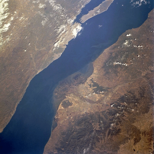
The Selenga River has deposited a sizeable delta along the southwest side of Lake Baykal. While over 300 streams flow into Lake Baykal [35-i02], the Selenga River is the largest single river system that enters the lake. Considering the depth of Lake Baykal (maximum depth 5710 feet-1741 meters) the amount of eroded sediment that has created such a large delta is impressive. The delta is a maze of interconnected waterways and wetland as expressed by the intermixing of colors and shapes (center of image). The dark red areas (green vegetation on this color infrared image) north and south of the braided channels of the delta of the Selenga River are forested land. The lighter-colored areas (towards center of image) show the extent of the agricultural activities (angular-looking field patterns) on the fertile delta.
Annually, the ground seismic stations register up to 2,000 earthquake tremors; the most sensitive seismographs, installed at various depths of the lake, identify them more frequently. In 1862, north of the Selenga's delta, an area of land of about 200 square kilometers sank under water to a depth of 2 meters as the result of an earthquake whose magnitude reached magnitude 11 (A. Voznesensky, www.irkutsk.org/baikal/geology ).