
THE MEKONG DELTA
Delta ID # 24.
Drainage basin:
Depositional basin: South China Sea.
Climate:
Air temperature range: oC to oC
Tidal amplitude:
Mean wave height:
Discharge:
Drainage Basin area:
Image ID:
Acquired:
Delta type
Geo-referenced files
Description
Contributed by Professor James Coleman, LSU. From: Coleman and Huh, 2004.

The Mekong River rises from its marshy source in the Tibetan Plateau and flows for some 4,350 km to empty into the South China Sea. The river follows generally follows north-south trending fold belts of Mesozoic age. In its upper reaches it flows through deep gorges and over rapids. The Mekong River is one of the larger rivers in southeast Asia. The drainage basin covers an area of 780,300 sq km. From its source, the Mekong follows a length of 4,350 km and displays a low gradient, as slight as 2.5 cm/km in the lower reaches. The average elevation of the drainage basin is 1,318 m, with a maximum of 5,423 m and a minimum of 30m. Relief is relatively low throughout most of the basin, averaging only 440 m. Tributary drainage density, however, is very high, averaging 0.23. Average annual rainfall is 1,303 mm, with a maximum of 2,263 mm and a minimum of 216 mm. The rainy months are May through October, coinciding with the yearly monsoons and average monthly rainfall rarely falls below 120 mm. During the dry months, average monthly rainfall ranges from 15 to 48 mm. Vegetation is extremely dense in the drainage basin and is dominated by tropical and subtropical moist broadleaf forests in the upper and central basins and tropical and subtropical dry broadleaf forests in the southern basin.
The alluvial valley is not well-defined and a dense network of tributaries enters the main river course along its entire length. Average annual river discharge is 10,314 m3/sec, with a maximum 21,872 m3/sec and a minimum of 1,505 m3/sec. Highest discharges occur from July through October. Much of the river course in the alluvial valley displays a meandering tendency. Population density is extremely dense along the river course and population density is quite high, density ranging from 3 to 18 people per sq km.
The river empties into the South China Sea, where offshore wave energy is moderate, resulting in wave reworking of the delta front sediments. Tidal range at the mouth of the Mekong is 2.59 m; the high tidal range, combined with monsoonal weather patterns, sets up relatively strong littoral currents that pass generally to the south. This high tidal range strongly influences the river channel, and shifting water-level effects extend up the main channels to Phnom Penh, a distance of 388 km. Sediment yield is quite high and the average annual sediment load is 170 million metric tons. The sediment consists of fine sands and clays.
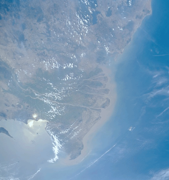
The Mekong delta covers an area of 93,781 km2 in Vietnam [24-i02]. This image of the delta is somewhat obscured by cloud cover that is common in the tropics. The delta is bounded to the north by pre-Quaternary surfaces, only a small area of which appears on the image. Pleistocene terraces border the river and delta; in the lower delta, these terraces gradually dip below the modern deltaic plain. To the southwest of the delta plain lies the Trans Bassac depression, a lowlands that parallels the main southern distributary, the Bassac. This region is one of the natural overflow basins of the Mekong system through which large volumes of river flow move westward to the Gulf of Thailand. This relatively featureless flat plain has been constructed by sediment drifting southwest along the coast from the river mouths and by overbank flooding. Much of the area consists primarily of brackish water marshes and small tidal channels bordered by mangrove vegetation. Some of the area has been reclaimed for agricultural purposes, and many of the long straight scars on the image represent irrigation canals. The largest basin in the delta is the vast, primarily uncultivated Plain of Reeds [upper left in 24-i02], which has an area of 4,560 km2. Cultivation is restricted mainly to the small channel banks of sluggish streams and along the long manmade canal banks that are used for drainage. The vegetation of this plain consists mainly of numerous species of Juncus, a fresh to brackish water marsh plant.
The subaerial delta of the Mekong is twice the size of the subaqueous delta plain. Most of the delta plain is active, but some areas between the distributaries receive little overbank sedimentation as a result of man-made levees constructed to prevent overbank flooding. The offshore slope fronting the delta is rather low, averaging 0.035 degrees. Over 60 million people depend on the Mekong and its tributaries for food, water, transport and many other aspects of their daily lives. Its annual flood-drought cycles are essential for the sustainable production of rice and vegetables on the floodplains and along the riverbanks during the dry season. Known as the Mother of waters, the river supports one of the world's most diverse fisheries, second only to the Amazon.
The major distributaries (six in number) of the delta plain are characterized by a braided pattern, with channel division around alluvial or mid-channel islands. Migration of channel banks is quite high and often erratic in nature. Most of the mid-channel islands have been diked and are heavily cultivated in rice. Among the most conspicuous landforms in this delta are the broad natural levees that border the active channels and surround the interdistributary basins (called bengs in Vietnam). These levees are relatively high, averaging several meters above the adjacent marshy interdistributary surface. Overbank splays are quite common and tend to form small erosional channels across a natural levee. These overbank channels are generally markedly straight and parallel to one another. The high tide, which constantly causes reversals in flow near the river mouths, results in well-developed bell- shaped river-mouth morphology containing numerous bars and spits that obstruct the river mouth. This type of channel-mouth morphology is quite common on most high-tide-dominated river deltas. Discharge down a particular distributary has varied with time, thus introducing pulses of sedimentation at a specific river mouth.
As a result of alternating progradation and coastal retreat, the morphology of the lower delta plain exhibits alternating stranded beach ridges and mudflats. This beach-dune ridge plain extends inland to distances up to 60 km. These stranded beaches or cheniers are composed of sand and shell, parallel the coastline, and display elevations up to 5 m above the adjacent swales. The swales are normally occupied by small tidal channels and salt- tolerant vegetation such as mangrove and Nipa palm. Coastal mudflat sediments underlie the salt marshes and swamps. The elevations of these ridges make them ideal sites for habitation and cultivation of oil palms. The delta shoreline is normally fronted by broad tidal mudflats that are exposed at low tide. Large volumes of organic debris that accumulate on these mudflats are extremely rich biologically.
Mangrove vegetation is spread throughout the lower delta plain and on the banks of the numerous small tidal channels. The bulk of the mangrove area, however, is situated in the tidal estuary located on the top right edge of the image on Plate 25. This basin lies "updrift" of the delta and is deprived of sediment nourishment from the adjacent river mouths. An intricate network of interconnected tidal channels cuts through the mangrove and Nipa palm swamps and marshes.