THE GANGES-bRAMAPUTRA DELTA
Delta ID # 10
Contributed by Huh et al, 2004.
Ganges-Brahmaputra River Delta, India, Asia
LOCATION LAT. 23°06’N, LONG. 90°21’E
LANDMASS DRAINED INDIA, ASIA.
BASIN OF DEPOSITION BAY OF BENGAL (INDIA OCEAN)
CLIMATE TROPICAL RAINFOREST (Am)
AIR TEMP RANGE 9.3°C TO 40.4°C
TIDAL AMPLITUDE 5.6 M
TYPE SEMIDIURNAL
MEAN WAVE HEIGHT LOW
DISCHARGE WATER 187,000 M
3/S SEDIMENT 167X106 TONS/YR,DRAINAGE BASIN AREA 1.597X10
6 KM2ID 7137044000133350, PATH 137 ROW 44
IMAGE ACQUIRED January 4, January 29. November 29, 2001
Delta type:
Image ID:7138044000111650, path 138, row 44.
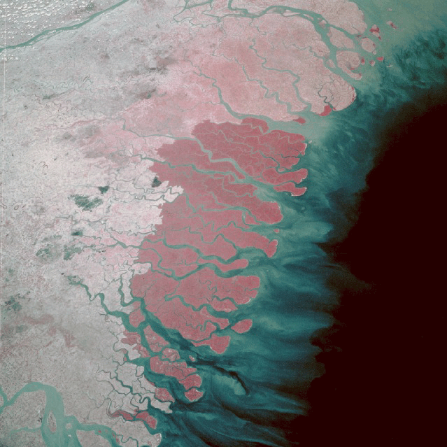
Image Acquired April 26th 2001.
Description
Contributed by Professor James Coleman, LSU. From: Coleman and Huh, 2004.

The Ganges and Brahmaputra rivers are one of the largest river systems on the earth. The river channels drain some of the highest mountains present on the planet, the Himalayans. The Ganges River originates near the Tibet/India border, and then flows southeast across India to combine with the Brahmaputra in the country of Bangladesh. The Brahmaputra River has its source in Tibet along the northern slope of the Himalayas, and flows across Assam into Bangladesh. The drainage basin covers an area of 1,664,700 sq km (Figure 42) and the combined length of the two major rivers exceeds 3,900 km. As can be seen the drainage network is exceedingly complicated and highly dense (tributary density = 0.24 km stream length per 500 sq km), one of the highest densities for a large drainage basin. The average elevation in the basin is 1,923 m, with maximum and minimum being 6,033 m and 180 m, respectively. The combined rivers drain both slopes of the Himalayan mountain chain. Paleozoic and Mesozoic, with scattered outcrops of Pre-Cambrian rocks make up the vast majority of the drainage basin. The headwaters are in the West Indian Shield and the Central Himalayan Foreland basins. In the northern part of the basin, mountain grasslands and alpine meadows are the dominant vegetation, while remainder of the basin is covered by deciduous forests and tropical and subtropical broadleaf forests. Average annual rainfall in the basin is relatively high (1,474 mm) with a maximum of 2,265 mm and a minimum of 341 mm. The rainy months range from June through September when monthly rainfall exceeds 100 mm. The dry months have average rainfall between 20 and 60 mm.
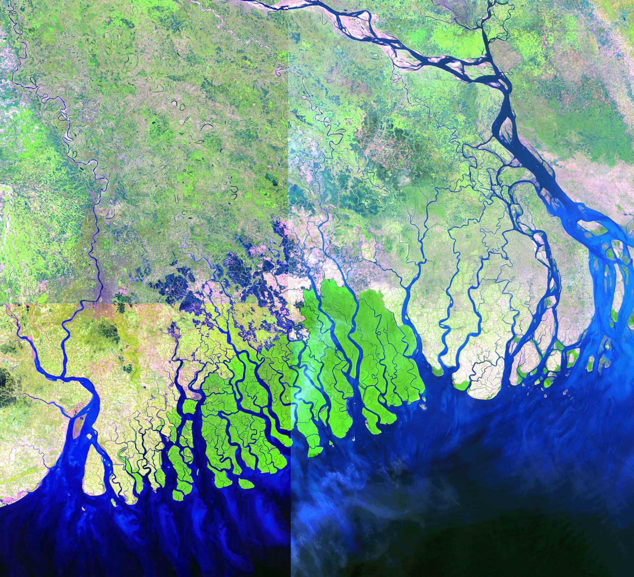
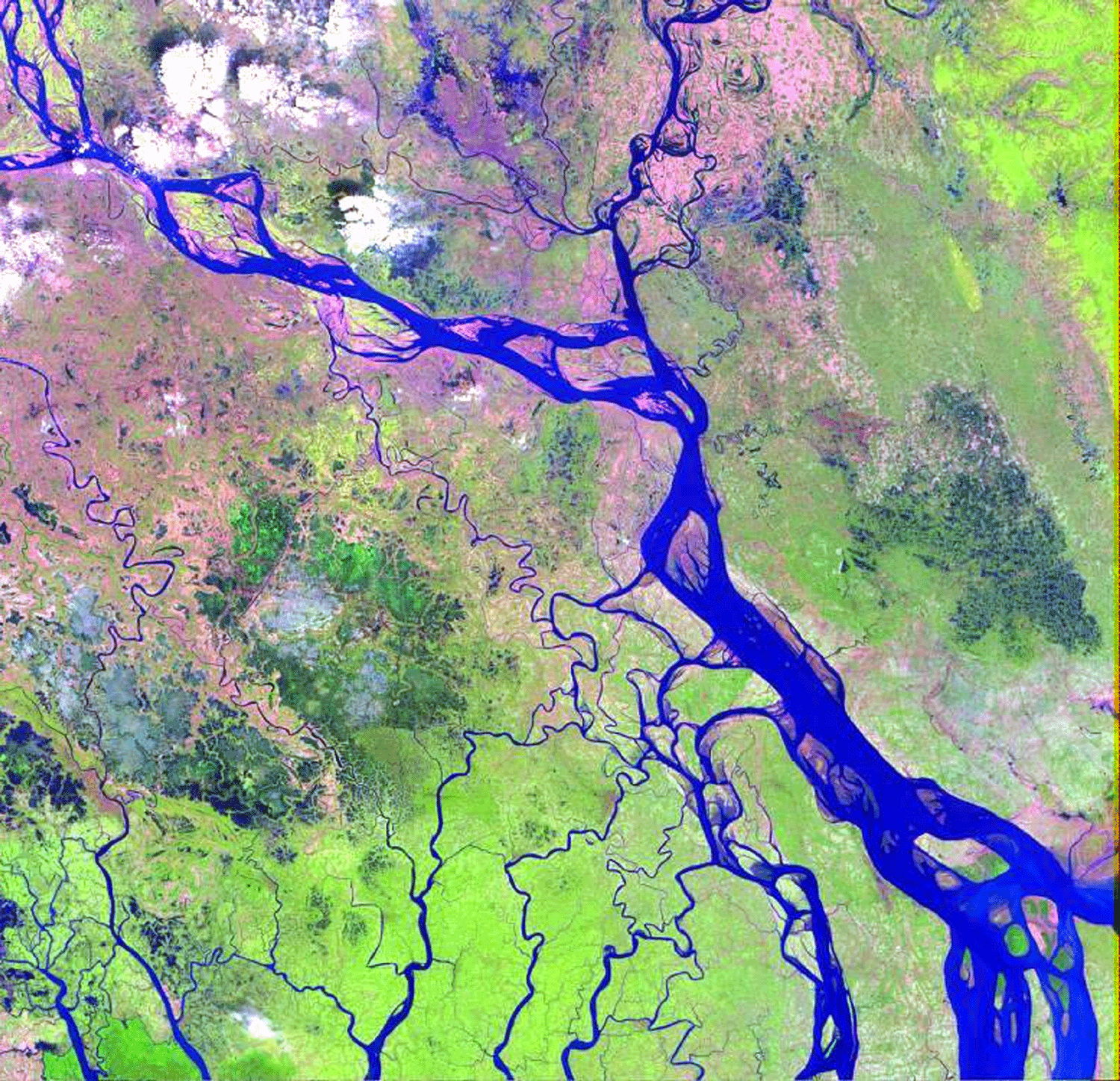
The Ganges is primarily a meandering river, while the Brahmaputra is primarily a braided channel. 10-i07 is a satellite image of the intersection of the two major rivers, the Ganges on the west and the Brahmaputra on the east. Their average annual combined discharge into the Bay of Bengal is approximately 29,692 m3/sec, with a maximum during flood of 80,984 m3/sec and 6,041 m3/sec during low water periods. The major floods occur during the months from June through September. The image shown in Figure 43 was taken during low water period; during flood season, most of the channel islands are inundated with flood waters. The channels of both rivers are extremely unstable and bank lines can migrate as much as 400 m in a single season (Coleman, 1969). Sediment load is extremely high, with suspended sediment load during flood stage reaching as high as 13 million tons per day (Coleman, 1969). Bedload has never been measured, but is obviously extremely high and consists of fine and medium grained sand. Most of the land in the alluvial valley is cultivated in rice and jute and population density is quite high, with 100 to 500 people per one-half degree area.
The delta, one of the largest in the world, covers some 105,640 sq km and has one of the highest population densities of all deltas. Throughout Pleistocene times, the site of active deltaic sedimentation has switched. Today, the Ganges merges with the Brahmaputra, and the site of active sedimentation lies to the east (Plate 10), where large bell-shaped distributaries can be discerned. The major area of abandoned deltaic plain lies to the west and is the site of one of the largest mangrove regions in the world, the Sunderbands. The abandoned delta is approximately 1.6 times the size of the active delta plain. Numerous abandoned channel scars dominate the surface morphology of the abandoned delta plain. These scars are apparently remnants of former courses of the Ganges River and many of its distributaries. Most of the scars indicate that a meandering channel was dominant, now extensively modified by man. Channel scars are of similar size to channels presently active along the Ganges and its distributaries. Many of these former riverine channels are now tidally dominated (10-i01).
The larger tidal channels form bell-shaped estuaries that are quite deep, and many of them serve as major transport arteries. Inland, the estuarine channels display highly sinuous channel patterns, but appear to be stable rather than migratory. Comparison of old maps and aerial photographs with present- day imagery indicates that some major channel patterns have not changed in tens of years. The tidal range varies considerably along this coast, mean tidal range is 3.6 m. Wave energy is relatively low, wave power being 0.585 x 10⁷ ergs/sec/m coastline and the root mean square wave height is 1.4 m. As a result of the low wave energy, few beaches are present along the shoreline and muddy tidal flats are common. The coastline is extremely irregular as a result of the large number of tidal channels that dissect the coast. Broad mud and silt flats border the coast. At low tide, many of these flats are exposed as fluid mud banks. Most of the banks display elongated patterns, aligned in an onshore- offshore direction. This type of subaqueous morphology is common along many high tidal estuaries, and these shoals have been called "tidal ridges." The few beach deposits that exist are most commonly composed of reworked shell debris and fine sand. These types of beach ridges have been referred to as cheniers on other delta coasts.
The offshore slope fronting the delta is extremely low, averaging 0.011 degrees. The ratio of the subaerial to subaqueous delta is 2.42, the subaerial delta being nearly 2.4 times the size of the subaqueous delta. Offshore of the delta is a large submarine canyon, the Swatch of No Ground. This submarine feature is a broad canyon that was formed during Pleistocene low sea levels, feeding fluvial sediment to one of the largest submarine fans in the world’s oceans.
The influence of humankind.
The inland part of the tidal plain has been diked, and the former saline lands have been converted to various agricultural and marine farming practices. This reclaimed land has retained some of the general morphology of the original deltaic channel scars, but it has been modified by tidal drainage networks. Originally, the entire surface of the abandoned delta formed an extreme expanse of mangrove forests. The only remaining large expanse of tidally dominated mangrove forests is shown on the image by the dark-green color and here dense stands of many species of mangrove exist. The mangrove swamp is dissected by an intricate network of tidal drainage channels.
Georegistered satellite images from 1989 and 2001 were compared to detect changes to the delta plain during this 12 year period. Because of the size of this delta, only a single satellite image was analyzed and is shown in Plate 10A. Note that this image is inland from the river mouth and does not include much of the coastal delta plain of the delta. The wetland area included in this image is 33,405 sq km (8,254,555 acres). Analysis of the 1989 image indicated that a total of 1,080,991 acres of open water existed in this image. By 2001, a total of 1,201,952 acres of open water was present and thus some 120,961 acres of new water was present in only this small portion of the delta plain. The Ganges-Brahmaputra River is a highly actively migratory river channel (Coleman, 1969) and most of the new open water was the result of natural migration of the river channel and formation of new channels. Plate 10A illustrates the changes detected. Note the major changes in the position of the main river channel shown in Plate 10A Note also, that some of the changes in open water is associated with enlargement of small lakes that are found throughout the delta. Thus in a 12 year period, an increase in open water was nearly 2 percent. The Ganges-Brahmaputra delta is one of the highest populated delta plains in the world. Plate 10B illustrates the primarily agricultural land use (colored green in Plate 10A) as determined on the 1989 image. A total of 1,975,207 acres (or 24%) of the original wetlands had been converted to agricultural use. Some 12 years later, a total of 2,523,100 of agriculture was analyzed on the 2001 image. This is an increase of 547,893 acres of wetlands that had been converted to agricultural land in the 12 year period or an increase of 22 percent during this time. These changes are shown in Plate 10B. Enlargement of the original high resolution geo-registered image indicates that a high percentage of the agricultural land is divided into small family parcels, generally on the scale of a few acres at most.
By 1989, some 3,056,198 acres of the original wetlands in this image scene along had been converted from a delta plain wetland to agricultural use. This represents approximately 37 percent loss. By 2001, some 3,725,052 acres of the original wetlands had been converted to open water or agricultural use, approximately a 45 percent loss. The average annual rate of wetland loss by natural causes and man’s modifications is 55,738 acres/year. Although this is but a single scene, browse images of the entire delta show a similar use of the delta plain. The only area in which agricultural expansion has not taken place in those areas where saline tidal waters intrude into the delta plain. The largest such area is the main mangrove covered tidal plain referred to as the Sunderbands. Examination of browse images show, however, that even in a short period of time, agricultural land is expanding into this region by construction of levees to prevent salt water intrusion.