THE BARAM DELTA
Delta ID #02
Contributed by Huh et al, 2004.
Baram River Delta, Malaysia, Asia
LOCATION LAT
. 4°20’N, LONG. 114°ELANDMASS DRAINED
ASIABASIN OF DEPOSITION
SOUTH CHINA SEACLIMATE TROPICAL RAINFOREST
(Af)AIR TEMPERATURE RANGE
210C-320CTYPE OF TIDE DIURNAL
ID
7119057109933050, PATH 119 ROW 57
Image Acquired NOVEMBER 2, 1999
COMMENTS DELTA TYPE
, CUSPATE, WAVE-DOMINATED
Geo-referenced files
Description
Contributed by Professor James Coleman, LSU. From: Coleman and Huh, 2004.

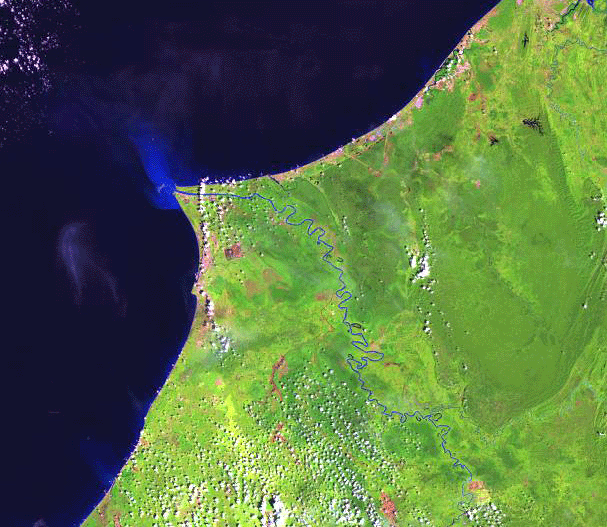
The Baram River is located in the state of Sarawak, Malaysia. The drainage basin covers some 17,760 sq km and is located in a tropical rainforest region. The average elevation is the basin is 602 m, with a maximum elevation of 4,833 m. Rainfall in the basin is quite high, averaging 3,225 mm annually and rainfall is spread throughout the year. The river is quite sinuous in nature (Plate 2 and Fig. 28), particularly in its lower reaches. The river empties into the South China Sea. The west coast of Sarawak and Brunei to the north consists of well-developed sandy beaches, resulting from a strong southwest longshore drift and a relatively high offshore wave action. All major rivers contribute to this sand / sediment deposition while minor rivers are diverted south to flow for long distances behind sandbars before reaching the sea.

The majority of rivers and coastal waters have high concentrations of total suspended solids. Most coasts are soft sediment-depositing shores while generally there is accretion rather than erosion. However, the coast in the vicinity of the Baram river is being eroded at a rate of 4-8 m per year, and at the mouth of the Baram River, nearly one kilometer of shore has been lost since 1985.
There is but a single distributary in the Baram delta and at the head of the delta, the river ceases to be meandering and the lower course of the river is relatively straight. The river mouth protrudes into the South China Sea some fifteen to twenty kilometers. The delta plain is generally free from cultivation and the entire region is covered by dense vegetation. Stranded beach ridges are the major geomorphic feature in the delta plain. The delta area is approximately 208 sq km in size. Evidence of relatively high wave energy is indicated by the extensive beach ridges that flank the river mouth.