THE ZAMBEZI DELTA
Delta ID # 42
Contributed by Huh et al, 2004.
Zambezi River Delta, Mozambique, Africa
LOCATION LAT. 18°47’S, LONG. 36°22’E
LANDMASS DRAINED CENTRAL AFRICA
BASIN OF DEPOSITION INDIAN OCEAN
AIR TEMP RANGE 16°C-26°C,
CLIMATE TROPICAL SAVANNA (Aw)
TYPE OF TIDE SEMIDIURNAL
DRAINAGE BASIN AREA 1.329X10
6 KM2ID 7166073000019851, PATH 166 ROW 73
IMAGE ACQUIRED JULY 16, 2000
Delta type
Geo-referenced files
Description
Contributed by Professor James Coleman, LSU. From: Coleman and Huh, 2004.

The Zambezi River arises in central Africa and the western portion of the drainage basin is located in the Quaternary and Tertiary sediments of the Etosha Basin. The central and eastern portion of the basin drains the PreCambrian Luffillian Arch and the East African Rift. The drainage basin has an area of 1,388,200 sq km and is sparsely vegetated with grasslands and savannas and flooded grasslands. The main channel of the Zambezi flows for some 2,650 km before entering the Indian Ocean. The drainage density is quite high and numerous dams have been constructed that impound large freshwater lakes (Figure 89). The average elevation in the basin is 1,058 m with a maximum of 1,847 m and a minimum of 333 m. The average annual rainfall is 955 mm, with a maximum of 1,518 mm and a minimum of 533 mm. The rainy months commence in November and last through mid April with an average monthly rainfall of 140 mm. The dry period is from mid-April through October and the monthly average rainfall rarely exceeds 20 mm. Thus there is distinct wet and dry periods within the basin.
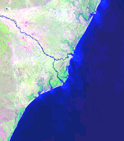
The alluvial valley is well-defined in its lower reaches and the channel displays a predominantly braided pattern. Average annual discharge is 3,341 cu m/sec, with a maximum of 4,558 cu m/sec and a minimum of 1,954 cu m/sec. The delta protrudes slightly into the Indian Ocean (42-i07) and has an area of 2,705 sq km. Wave energy is quite high and numerous beach ridges are found abandoned within the delta plain, alongshore away from the delta, and flanking the river mouths. Tidal influence is best expressed south and north of the delta, where broad tidal basins exist. Within the delta plain, abandoned channels are present, indicating rather active changes in the distributary channels. Extensive mangroves are present in the lower delta (deep red colored in 42-i05 and in the tidal basins. Salt flats are common in the interdistributary basins and vegetation is sparse. The river carries a substantial silt and clay suspended load and the distinct sediment plumes are visible in the satellite image.
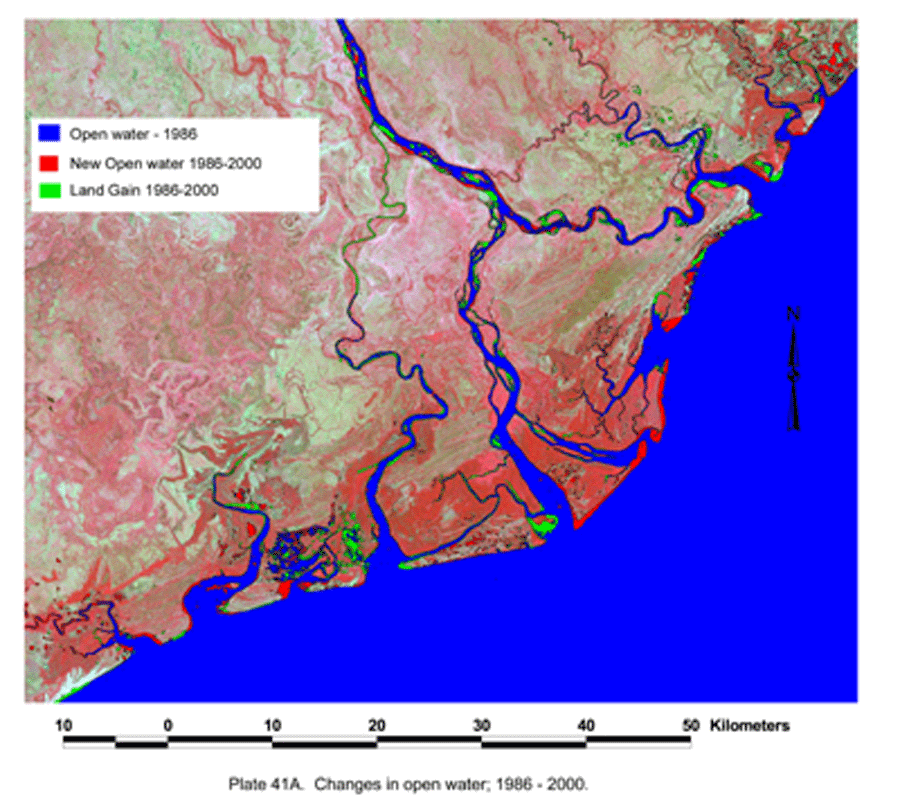
The lower delta plain is virtually absent of any agricultural or industrial land use. Comparison of 1986 [42-i06] and 2000 [42-i07] satellite images indicates that coastal erosion is quite high along the delta front [42-i05]. Some 11,322 acres of wetlands and coastal barriers have been lost in the fourteen year period between the satellite images. The only significant land gain is along some of the tidal channels and at the mouths of the main channels [42-i03]. In the fourteen year period, some 5,388 acres if new delta plain sediments has been formed, thus there has been a net loss of delta plain wetland of 5,934 acres. This represents an average annual rate of wetland loss of 424 acres/year.
The influence of humankind.
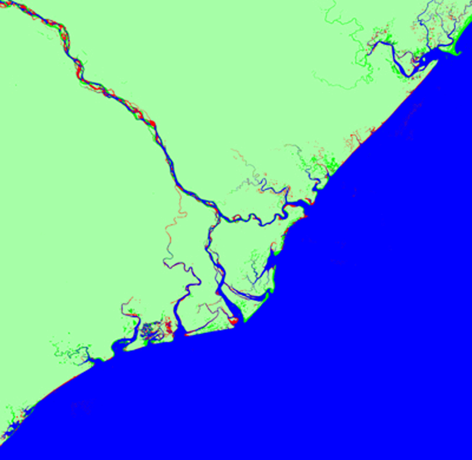
There is virtually no agricultural or industrial use in the lower delta plain, but at the head of the delta the upper delta plain, is undergoing some change to agricultural use. This is especially so in the areas adjacent to the active channel [42-i02]. In 1986, a total of only 5,313 acres of land were under cultivation. But by the year 2000, a total of 85,677 acres were utilized for agricultural purposes, an increase of 80,364 acres [42-i04]. This represents an annual rate of delta plain loss of 5,740 acres/year. As agricultural practices increase and levees are constructed to block tidal water incursions, it is highly probable that land reclamation will continue to expand into the lower delta.