THE SENEGAL DELTA
Delta ID # 37.
Contributed by Huh et al, 2004.
Senegal River Delta, Senegal, Africa.
LOCATION LAT. 15°54’N, LONG. 16°22’W
LANDMASS DRAINED AFRICA
BASIN OF DEPOSITION ATLANTIC OCEAN
CLIMATE TROPICAL STEPPE (BShw)
AIR TEMP RANGE 22°C - 37°C,
TIDAL AMPLITUDE 1.2 M
TYPE SEMIDIURNAL
ID 7205049000301550, PATH 205 ROW 49
MAGE ACQUIRED JANUARY 15, 2003
Delta type
Geo-referenced files
Description
Contributed by Professor James Coleman, LSU. From: Coleman and Huh, 2004.

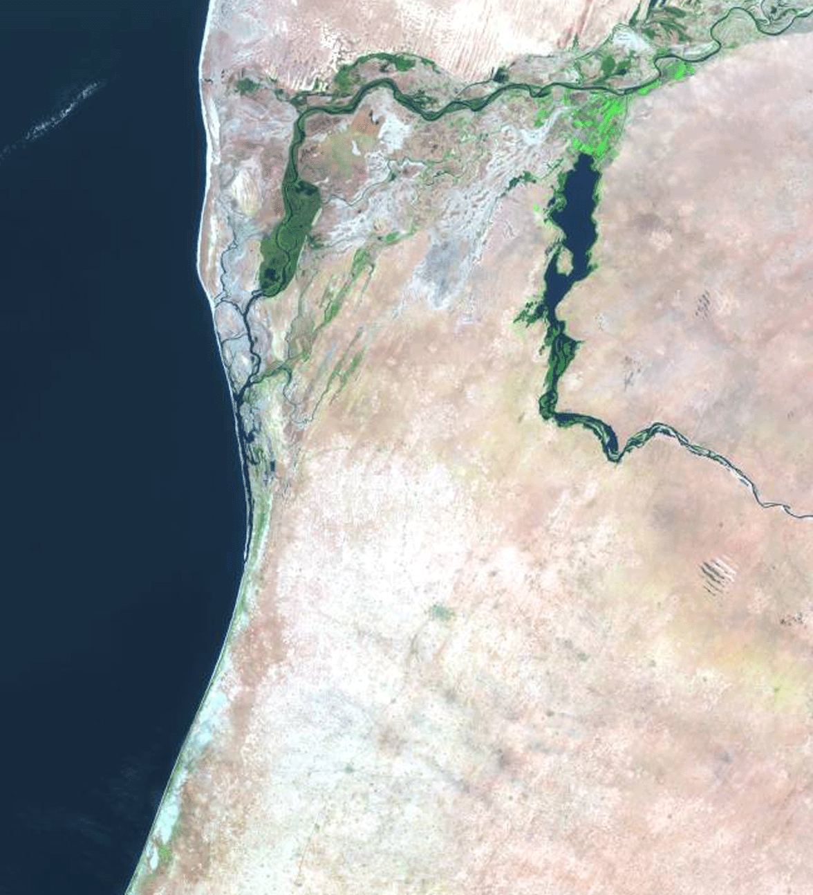
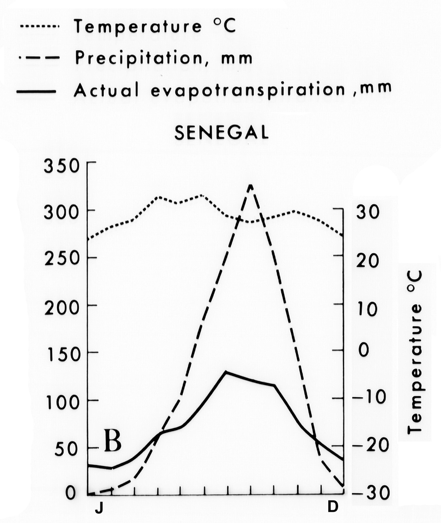
The Senegal River is formed by the confluence of two smaller rivers, the Bafing and Bakoye. The drainage basin has an area of 437,000 sq km. Most of the basin is surrounded by harsh desert conditions and the northern part of the basin drains Quaternary sand dunes while the remainder is located in the Foouderi Basin of central Africa. The northern basin consists almost entirely of barren desert scrub vegetation and the remainder of the basin is dominated by tropical and subtropical grasslands and savannas. Drainage density is relatively low, averaging 0.16 stream length per 500 sq km (Figure 82). Several dams have been constructed in the northern part of the basin, forming small lakes, and provide the only source of fresh water for irrigation. The main channel of the Senegal flows from its headwaters in the southern part of the basin for a distance of 1,190 km before entering the Atlantic Ocean. The average elevation in the basin is 250 m, with a maximum of 803 m and a minimum of 23 m (northern part of basin). Relief throughout the basin is extremely low, the average relief being only 40 m. Average annual rainfall is 657 mm with a maximum of 1,902 mm and a minimum of 111 mm. The rainy season commences in June and lasts through October, with an average monthly rainfall of 100 mm; peak rainfall occurs in August, averaging 204 mm. The dry season is from November through May and the average rainfall rarely exceeds 10 mm per month. Thus there are distinct wet and dry seasons [37-g03].
The alluvial valley is well-defined [37-i02] and the main channel displays primarily a meandering pattern [37-i01]. The valley has a length of approximately 600 km and the width varies from narrow sections barely 15 km wide to extremely broad reaches that attain widths of nearly 75 km. The average annual discharge is 841 cu m/sec, with a maximum of 3,138 cu m/sec (August/September) and a minimum of 5 cu m/sec (April/May). The sediment load consists primarily of fine-grained clays and silts, with minor amounts of medium sand as bedload. The delta plain of the Senegal does not protrude significantly into the Atlantic Ocean, yet has formed quite a large delta, some 4,254 sq km in area. Most of the delta is subaerial in nature, the ratio of the subaerial to subaqueous delta being 20.10. The tidal range along the coast is 1.22 m, with a maximum spring tide of 1.9 m, but because of the high relief in the delta, only 10% of the delta plain is inundated by tidal waters. Wave energy is extremely high, one of the highest of all river deltas and the average root mean square wave height is 1.61 m. The average annual wave power is 112.42 x 10⁷ ergs/sec/m coast, or more wave energy hits this delta coast in 3 hours than in 365 days in the Mississippi delta.
Figure 83 illustrates the monthly wave power at three points along the coast. Note that the wave energy is quite peaked, the maximum wave energy occurring during the months of July and August. Offshore slope is quite steep (0.479 degrees) and the Atlantic Ocean swell breaks directly on the shoreline. In addition, strong unidirectional littoral currents to the south are operative, and drift velocities approaching 1 m/sec move large volumes of sediment alongshore. This strong southward drifts results in an extremely skewed pattern of the lower part of the river. The apex of the delta is located 160 km upstream from its mouth and flows generally in a western direction until it approaches the coast, where it suddenly is diverted southward along the coast for some 22 km by the strong littoral drift. The abandoned distributary channels within the older delta plain display a similar southward deflection.
The entire delta plain is characterized by large sandy and vegetated beach barrier islands [37-g02], separated by broad, heavily vegetated abandoned river courses. Radiocarbon dating of some of these stranded barriers indicate that within the past 5,000 years, some 8.5 km of seaward accretion has taken place. Some of these stranded barrier ridges exceed 2.5 km in width and have lengths approaching 80 km. The westward bank of the active river channel where it is diverted southward consists of a long beach barrier system capped by large eolian dunes, some attaining heights of 16 m in elevation. As the river approaches the coast, strong littoral drift deflects the river channel along the coast and high wave action reworks the river borne clastics into a broad, active beach. With continued progradation parallel to the coast, the stream gradient decreases. At some point the river will cut across its own barrier, either during floods or large tropical storms. The channel will again be deflected southward and a new barrier will be formed seaward.
Note that in the delta plain, the only vegetated regions are associated with the active river channel or the swales and abandoned channels in the delta plain [37-g01]. These regions are represented by the linear green reflections in the satellite image. Because of the high evaporation rate, salt flats are present throughout the delta plain. The entire delta is completely surrounded by dune-covered deserts.