
THE NIGER DELTA
Delta ID # 26.
Contributed by Huh et al, 2004.
Niger River Delta, Nigeria, Africa
LOCATION LAT
. 4°20’N, LONG. 5°50’ELANDMASS DRAINED AFRICA
BASIN OF DEPOSITION ATLANTIC OCEAN
CLIMATE TROPICAL RAINFOREST
(Am)AIR TEMP RANGE
20.9°C TO 35°C,TIDAL AMPLITUDE
2.2 MTYPE SEMIDIURNAL
MEAN WAVE HEIGHT MODERATE
DISCHARGE WATER
61000M3/S SEDIMENT; 40X106 TONS/YRDRAINAGE BASIN AREA
1.112X10⁶ KM2ID
7189057000100950, PATH 189 ROW 57
IMAGE ACQUIRED JANUARY 9, 2001
Geo-referenced files
Description
Contributed by Professor James Coleman, LSU. From: Coleman and Huh, 2004.

The source of the Niger River is in the pre-Cambrian West African Shield region of interior Africa. The central part of the basin, where the "inner delta" is located is in the Central Tertiary Basin. The drainage basin has an area of 2,117,700 sq km and the drainage density is quite high (drainage density of 0.20 km stream length per 500 sq km), especially in the northern part of the basin. The main course of the Niger river has a length of 4,350 km from its headwaters to the mouths of the delta. Average basin elevation is relatively low, some 431 m with a maximum of 1,693 m and a minimum of 157 m (in the inner delta region). Annual average rainfall is 672 mm per year, with a maximum of 2,247 mm and a minimum of only 8 mm. The wet season occurs in July through September and average monthly rainfall generally exceeds 120 mm. The dry season commences in mid-October and lasts through the month of May, where monthly rainfall rarely exceeds 10 mm per month.
26-g04: Temperature and Precipitation of the Niger Delta.
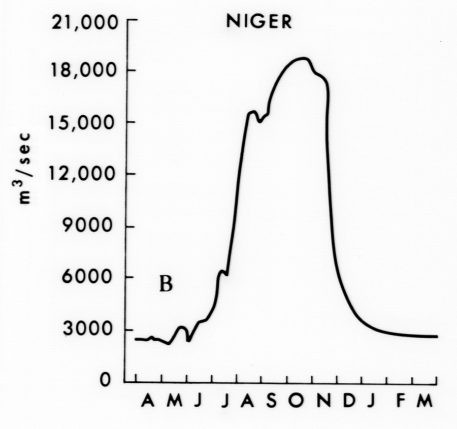
23-g01: River Discharge for the Niger Delta.
River discharge averages some 1,045 cu m/sec annually, with a peak discharge of 1,424 cu m/sec in October and a minimum discharge of 750 cu m/sec in March. A very pronounced feature within the alluvial valley is the presence of an "inner delta" (Figure 65). The total area covered by the inner delta, which is a network of tributaries, channels, swamps and lakes, can reach about 30,000 km2 in flood season. The delta area is swampy and the soil sandy. This inner delta has formed in a large cratonic basin, the E1-Djouf or Taoudene. The alluvial valley is generally well-defined, especially in the region below the inner delta.
23-g02: Geomorphology of the Niger Delta.
The delta of the Niger displays a relatively smooth lobate pattern. The delta covers an extremely large area, some 19,135 sq km in area. The subaerial delta is nearly eight times larger than the subaqueous delta, probably as a result of the relatively high near shore wave action and the presence of strong littoral currents. As a result of the extremely high density of active distributaries, only about one-half of the delta is in a inactive state. Wave energy is relatively high along the delta front and Figure 66 illustrates the monthly average wave power along the delta front. Note that wave energy is relatively uniform at all of the stations fronting the delta and that the highest wave action occur in the months of June through October. The lobate nature of the delta generally results from the alongshore wave energy gradients.
26-i04: Lobate front of the Niger Delta.
From the central part of the delta, the alongshore wave energy gradient diverges to the northwest and the east. Root mean square wave height is 1.11 m [figure 66, Coleman and Huh, 2004.].
The satellite image shown in 26-i03 is partially obscured by clouds, but the complex nature of the distributary pattern can be discerned.
Approximately eleven active river mouths exist and the distributary density is quite high, averaging some 0.48 km stream length per 500 sq km, one of the highest of the deltas described. Most of the interior part of the delta is densely vegetated and mangroves dominate the vegetation along the fringes of the delta.
26-i02: Mangrove Swamps of the Niger Delta.
The dark green areas displayed along the coast illustrate the extent of the dense mangrove cover. One of the more prominent features of the delta is the relatively large and complex tidal channels that front most of the delta.
26-i03: Tidal channels at the front of the Niger Delta.
Tidal range is moderate, with an average tidal range of 1.43 m. The enhanced satellite image shown in www.aaas.org/international/ssd/nigerdelta illustrate the major geomorphic features found in the lower delta. Intricate tidal channels extend from the shoreline into the interior part of the delta. The active distributaries are tidally dominated and often display typical bell-shaped river mouths. The presence of strong coastal currents is indicated by the deflection of the river mouths in a down drift direction . Because of the relatively high wave action, most of the coast displays active sandy beaches and barriers along the coast. The satellite image illustrates the complex nature of the tidal channels that from between the major distributaries. The dark brown region found in the tidal region represent mangrove vegetation. A diagram of the distribution of Mangrove swamps over the delta is shown in 26-g03.
26-g03: Graphic showing the distribution of Mangrove Swamps over the Niger Delta.
26-i05: Mosaic of Niger Delta satellite images.