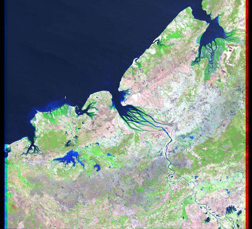
THE DETSIBOKA DELTA
Delta ID # 43.
Contributed by Huh et al, 2004.
Betsiboka River Delta, Madagascar, Africa
LOCATION LAT. 15°54’S, LONG. 46°18’E
LANDMASS DRAINED MADAGASCAR ISLAND
BASIN OF DEPOSITION INDIAN OCEAN
CLIMATE TROPICAL SAVANNA (Aw)
TYPE OF TIDE SEMIDIURNAL
AIR TEMP RANGE 21°C – 35°C,
ID 7160071000026850, PATH 160 ROW 71
IMAGE ACQUIRED SEPTEMBER 24, 2000
Delta type:
Geo-referenced files
Description
The influence of humankind.
On June, 1983 the near-vertical satellite image STS007-03-0058 [JSC] was taken of the Betsiboka River Delta, Madagascar. The image shows dramatic evidence of the catastrophic erosion of northwestern Madagascar with the rapid expansion of the delta. Clear cutting of the native forest for cultivation and pastureland during the past 50 years has led to massive annual soil losses approaching 112 tons per acre (250 metric tons per hectare) in some regions of the island. This is the largest amount recorded anywhere in the world. The image provides convincing evidence of the result of this process, as the effects of water erosion are seen throughout the 1544-square-mile (4000-square-kilometer) land surface area of the photograph. The delta continues to build toward the mouth of Bombetoka Bay, which enters the Mozambique Channel.