 |
|
Research
> Research Groups > Geophysics and Tectonics
|
|
Geophysics and Tectonics |
Global earth science problems are as
diverse as the techniques we use to tackle them. Geophysics and
Tectonic studies combine field-based data acquisition and simplification
of earth processes through understanding physical principles, and
comprehensive mathematical and experimental methods.
|
|
Active
Research Programs |
Tectonics
- Tectonism of Archean
greenstone belts
- Effects of large
meteorite impacts
- Temporal and kinematic evolution of
orogenic belts
- Tectonometamorphism of high grade
metamorphic terranes
|
Climate
Change and Quantitative Geomorphology
-
Global climate patterns: Multichannel seismic images of Antarctica
- Sediment and climate interaction
--Gulf Coast Offshore Sequence Stratigraphy from single-channel
seismic images
- Quaternary paleoclimate studies from
geophysical characterization of sedimentary sequences
- Quantitative geomorphological modeling
of uplift/erosion in a variety of geological settings
|
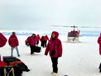
Embarking at Antarctic field location (Bart)
|
Sediments, Fluids and Faults
- Fault networks in aquifers from 3D
seismic images and ground penetrating radar
- Overpressuring in sediments from 3D
seismic attributes
- Tectonic evolution of rift basins
- Gravity, flexure, and rheology of the
lithosphere
- Heat flow and evolution of sedimentary
basins
- Fluid-flow models in fault zones:
X-Ray tomographic characterization of fault zones
- Global and regional correlation using
magnetic susceptibility and biostratigraphic data sets
|
|
Techniques and Analytical Facilities |
Industry -
Education Programs
- 2D and 3D Seismic Visualization,
Seismic Modeling and Analysis (Landmark Graphics, and Seismic
Microtechnology)
- 2D and 3D seismic processing (OmegaSPS
and ProMAX)
- Subsurface Industry-Sponsored
Laboratory with 2D and 3D geophysical data sets
- Velocity Modeling System (Kahlstrom
and Associates)
Field and
LaboratoryEquipment
- Rock Magnetism Laboratory, NSF
Computation and Visualization Laboratory
- Lacoste-Romberg type "G" and Worden
gravimeters
- Differential GPS and 5” digital
theodolites
- RadioTelemetry 600-channel 3D seismic
acquisition and 24-channel seismograph
- Single-channel marine acquisition
system
- 4x4 and 6x6 all-terrain and amphibious
field vehicles
- Drilling truck and core refrigeration
unit
- Geophones:1-Hz borehole, 40Hz, 100 Hz
vertical, 14 Hz shear
- Downhole shotgun, I-beam-,
plate-hammer, 0.22 power-hammer, accelerated weight
- Resistivity, Ground Penetrating Radar
|
|
Field
areas |
- Albania, Argentina, Belgium, Bolivia,
Czech Republic, France, Germany, Italy, Morocco, Portugal, Spain,
Vietnam (Ellwood)
- China (Darby)
-
East & West Antarctica, Gulf of Mexico (Bart)
- Chile, Colombia, Australia, Gulf of
Mexico (Lorenzo, Nunn)
- South
Africa (Byerly)
- North America - Cascades (Tomkin), -
Beartooth Mountains (Henry)
|
 |
|
For
more information |
|
|
|